MyTopo
Trappe Maryland US Topo Map
Couldn't load pickup availability
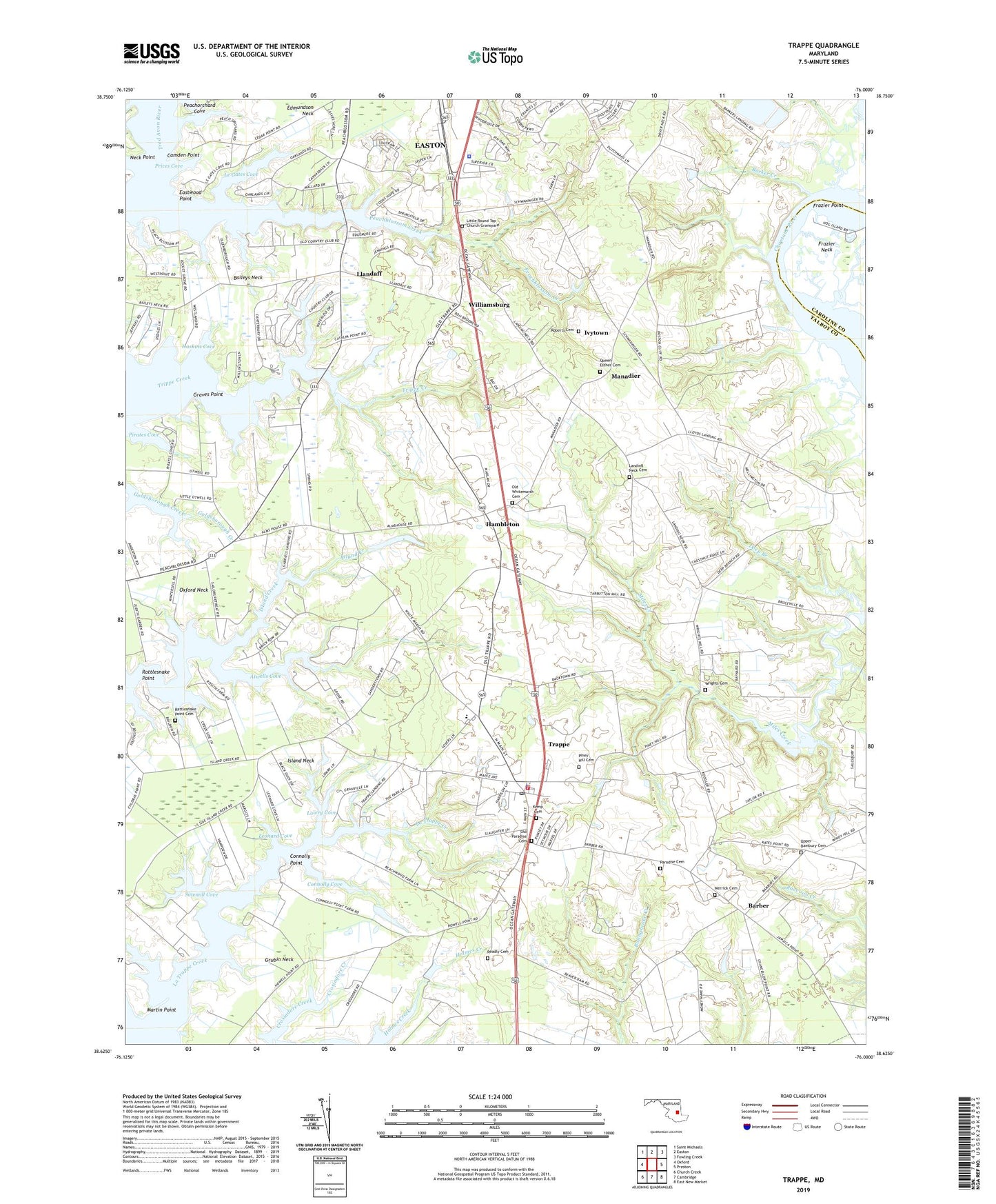
2023 topographic map quadrangle Trappe in the state of Maryland. Scale: 1:24000. Based on the newly updated USGS 7.5' US Topo map series, this map is in the following counties: Talbot, Caroline. The map contains contour data, water features, and other items you are used to seeing on USGS maps, but also has updated roads and other features. This is the next generation of topographic maps. Printed on high-quality waterproof paper with UV fade-resistant inks.
Quads adjacent to this one:
West: Oxford
Northwest: Saint Michaels
North: Easton
Northeast: Fowling Creek
East: Preston
Southeast: East New Market
South: Cambridge
Southwest: Church Creek
This map covers the same area as the classic USGS quad with code o38076f1.
Contains the following named places: Atwells Cove, Baileys Neck, Barber, Barker Creek, Beechwood, Bristolwood, Camden Point, Camden Point Farm, Canterbury, Cedar Point, Choptank Wetlands Preserve, Connolly Cove, Connolly Point, Connolly Point Farms, Cooks Hope, Country Club Estates, Crosiadore Creek, Crosiadore Farm, Deep Branch, District 3 Trappe, Dream Landing Farm, Easton Primary Sewage Lagoon Dam, Easton Secondary Sewage Lagoon Dam, Eastwood Point, Edmundson Neck, Ellenborough, Frankford, Frazier Point, Gilnock Hall, Graves Point, Grubin Neck, Hambleton, Hampton, Haskins Cove, Holly Oaks, Immanual Church, Island Neck, Ivytown, Kemp Cemetery, La Trappe Heights, Landing Neck Cemetery, Landing Neck Church, Le Gates Cove, Leonard Cove, Little Round Top Church, Little Round Top Church Graveyard, Llandaff, Locust Grove, Lower Peach Blossom Farms, Lowry Cove, Manadier, Martin Point, Maryland State Police - Barrack I Easton, Merrick Cemetery, Midshore Regional Landfill, Mount Pleasant Farm, Neck Point, Oaklands, Old Paradise Cemetery, Old Whitemarsh Cemetery, Old Whitemarsh Church, Otwell Woodland Preserve, Palmer Farms, Paradise Cemetery, Patrick Plains, Peach Blossom Heights, Peach Orchard, Peachblossom, Peachblossom Creek, Peachorchard Cove, Piney Hill Cemetery, Pirates Cove, Prices Cove, Queen Esther African Methodist Episcopal Church, Queen Esther Cemetery, Rattlesnake Point, Rattlesnake Point Cemetery, Readly Cemetery, Roberts Cemetery, Sailors Retreat, Saint Pauls Episcopal Church, Sawmill Cove, Scotts United Methodist Church, Seth State Forest, South Beechwood, Springfield, Talbot Country Club, Talbot Country Club Pond Dam, Town of Trappe, Trappe, Trappe City Hall, Trappe Landing, Trappe Park, Trappe Police Department, Trappe Post Office, Trappe Public School, Trappe Station, Trappe United Methodist Church, Trappe Volunteer Fire Company Station 30, Upper Bambury Cemetery, Waverly Island Estates, WFBR-FM (Cambridge), White Marsh Elementary School, Williamsburg, Williamsburg United Methodist Church, Wrights Cemetery, ZIP Code: 21673