MyTopo
Clarksville Maryland US Topo Map
Couldn't load pickup availability
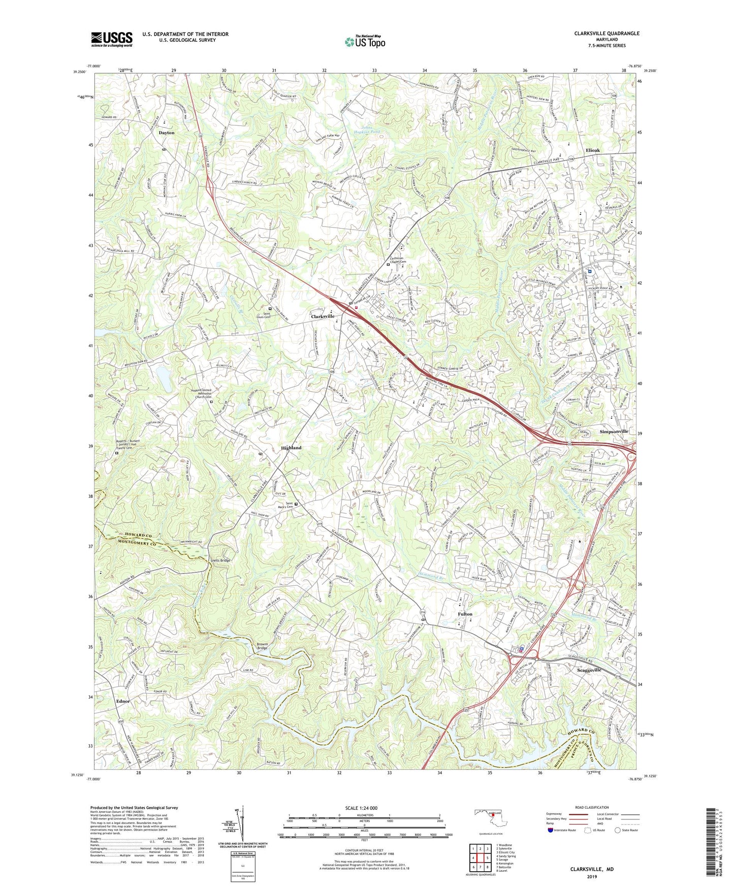
2019 topographic map quadrangle Clarksville in the state of Maryland. Scale: 1:24000. Based on the newly updated USGS 7.5' US Topo map series, this map is in the following counties: Howard, Montgomery, Prince George's. The map contains contour data, water features, and other items you are used to seeing on USGS maps, but also has updated roads and other features. This is the next generation of topographic maps. Printed on high-quality waterproof paper with UV fade-resistant inks.
Quads adjacent to this one:
West: Sandy Spring
Northwest: Woodbine
North: Sykesville
Northeast: Ellicott City
East: Savage
Southeast: Laurel
South: Beltsville
Southwest: Kensington
Contains the following named places: Abiding Savior Lutheran Church, Allnut Farms Estates, Anne Arundel County Fire Department, Applications and Research Laboratory, Ashmead, Ashton Pond, Ashton United Methodist Church, Atholton High School, Beaufort Park, Beech Creek, Beth Shalom Congregation, Braeburn, Briaridge, Brighton Farm Estates, Brighton Pines, Broadwater Estates, Brookfield Christian Elementary School, Brown Chapel United Methodist Church, Browns Bridge, Cabin Hill, Carrolls Branch, Cedar Acres, Cedar Knoll Farms, Cedar Lane Park, Cedar Lane School, Cedar Woods, Chapel Woods, Chelsea Estates, Cherry Tree Farm, Chris Mar Estates, Chriswood Manor, Church of God Camp, Cissel Farm, Clarksville, Clarksville Elementary School, Clarksville Environmental Area, Clarksville Fire Station, Clarksville Meadows, Clarksville Middle School, Clarksville Post Office, Clarksville Ridge, Clarys Forest, Clemens Crossing, Cliftonbrook, Columbia Montessori School, Coon Manor, Dayton, Dayton Four Square Gospel Church, Dayton Meadows, Dayton Oaks Elementary School, Dayton Post Office, Dayton School, District 5 Clarksville, Dogwood, Dunfretten Estates, Earleigh Heights Volunteer Fire Company 12, Ednor, Ednor Acres, Ednor Aston Recreation Center, Ednor Farms, Ednor View, Elioak, Emmanuel United Methodist Church, Farside, Faulkner Ridge, Faulkner Ridge Elementary School, Fifth District Volunteer Fire Department, Flamewood, Foreman Branch Dam, Forest Hills, Fox Pause, Foxhall Villas, Fulton, Fulton Census Designated Place, Fulton Elementary School, Fulton Post Office, Gaither Farm Estates, Gateway School, Goddard School for Early Child Education, Graeloch Woods, Green Hill Manor, Greene Fields, Greenwood Farm, Greenwood Farms, Hall Shop Estates, Hallmark, Hammond Elementary School, Hammond Hills, Hammond Middle School, Hammond Park, Hammond Village, Harmony Hall Retirement Community, Harpers Choice, Harper's Choice Middle School, Haviland Hills, Hawthorn, Hawthorn North, Hawthorn Park, Haysfield Airport, Hemlock Hill, Heritage Heights, High Road Academy, Highland, Highland Acres, Highland Census Designated Place, Highland Lake, Highland Post Office, Hillcrest Heights, Hobbits Glen, Hobbits Glen Golf Course, Holiday Hills, Holly House, Homewood School, Hopkins Applied Physics Lab, Hopkins Mead, Hopkins School, Hopkins United Methodist Church, Hopkins United Methodist Church Cemetery, Howard County Community College, Howard County Fire Department Station 11, Howard County General Hospital, Howard County General Hospital Heliport, Howard County Police Department Southern District, Jacobsville Fire Station Company 10, Jocelyn Acres, Johns Hopkins Pond, Johns Hopkins University Dam, Joseph Square Shopping Center, Kindler Estates, Kingdom Hall of Jehovahs Witnesses, Kings Manor, Knowledge Beginnings, La Isla, Leishear Knolls, Leishear Village, Lime Kiln Middle School, Lime Kiln Valley, Linden Chapel Hills, Linden Chapel Woods, Linden Church, Linden-Linthicum United Methodist Church, Linthicum Chapel, Linthicum Chapel Cemetery, Little Patuxent KinderCare, Locust United Methodist Church, Longfellow, Longfellow Elementary School, Maple Lawn Farms, Mater Amoris School, Mauck Farm Estates, Middle Patuxent Environmental Area, Mill Grove Gardens, Montpelier Research Park, Mooresfield, Mount Pisgah AME Church, Mount Zion United Methodist Church, Murray Hill, Nature's Way Children's Center West, New Hope Adventist Church, Oak Hill Estates, Patuxent Hills, Pembroke Knolls, Pine Valley, Point of Homewood, Pointers Run Elementary School, Raintree Estates, Reservoir High School, River Hill High School, Riverside, Riverside Estates, Roberts / Burkett / Dorsey / Hall Family Cemetery, Robinson Nature Center, Rocky Gorge Driving Range, Rocky Gorge Meadows, Rocky Gorge Reservoir, Rolling Hills Baptist Church, Saint Louis Cemetery, Saint Louis Roman Catholic Church, Saint Louis School, Saint Mark's Cemetery, Saint Marks Church, Saint Pauls Evangelical Lutheran Church, Saybrook, Scaggsville, Scaggsville Census Designated Place, Scaggsville Fire Station, School Number 18, Schooley Mill Park, Scott Acres, Scotts Cove Campground, Silver Medallion Farm, Simpson Woods, Simpsonville, Skunk Cabbage Creek, Snells Bridge, Spring Lake Farms, Swann Hills, Swansfield, Swansfield Elementary School, Tai Sophia Institute, The Chase, The Young School, Tower Acres, Tubman High School, Twelve Hills, Twin Oaks, Waterford, Wearon Rolling Hills Church, White Oak Estates, Wilde Lake Middle School, Williams Contrivance Estates, Wood Ridge, ZIP Codes: 20759, 20777, 20861, 20868, 21029, 21044