MyTopo
Ellicott City Maryland US Topo Map
Couldn't load pickup availability
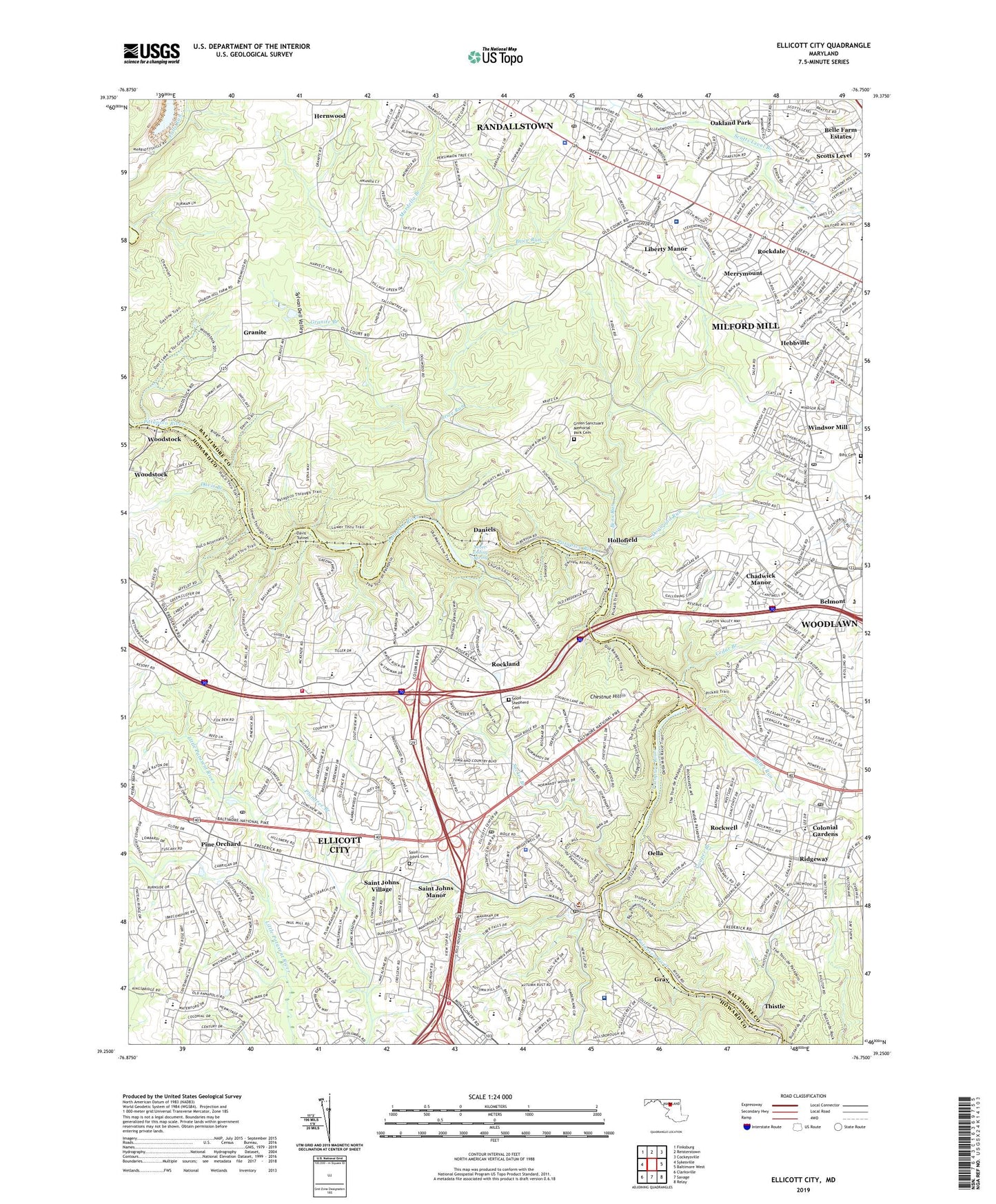
2023 topographic map quadrangle Ellicott City in the state of Maryland. Scale: 1:24000. Based on the newly updated USGS 7.5' US Topo map series, this map is in the following counties: Baltimore, Howard, Carroll. The map contains contour data, water features, and other items you are used to seeing on USGS maps, but also has updated roads and other features. This is the next generation of topographic maps. Printed on high-quality waterproof paper with UV fade-resistant inks.
Quads adjacent to this one:
West: Sykesville
Northwest: Finksburg
North: Reisterstown
Northeast: Cockeysville
East: Baltimore West
Southeast: Relay
South: Savage
Southwest: Clarksville
This map covers the same area as the classic USGS quad with code o39076c7.
Contains the following named places: Adil Meadows, Alberton, Allenford, Autumn Hill, Autumn Hill Branch, Belle Farm Estates, Belmont, Bens Run, Bethany Manor, Bethgate, Bethwood, Bihy Cemetery, Braebrooke, Brenbrook Plaza Shopping Center, Brennan Convalescent Home, Brice Run, Brinkleigh, Brinkleigh Manor, Brittany, Burleigh Manor, Carriage Hill Village, Carriage Hills Park, Catonsville Gateway, Catonsville Park, Cedar Branch, Centennial Manor, Chadwick Manor, Chadwick Shopping Center, Chalfone Manor, Chamberlea, Chapelview, Chateau Ridge, Chateau Valley, Chatham, Chatham Gardens, Chatham Mall Shopping Center, Chestnut Farms, Chestnut Hill, Chestnut Hill Estates, Colonial Gardens, Cooper Branch, Crestleigh, Crown Estates Park, Cypressmeade Park, Damiels Dam, Daniels, David W Force Park, Davis, Davis Branch, Davis Tunnel, Diamond Ridge Golf Course, District 2, District 2 Ellicott City, Dogwood Run, Dorsey Hall, Dorseys Run, Drexel Woods, Dunloggin, Dunloggin Park, Dunmoor Woods, Ellicott Center Industrial Park, Ellicott City, Ellicott City Census Designated Place, Ellicott City Historic District, Ellicott Hills, Fair Brook, Fairway Hill, Fields of Harvest, Font Hill Manor, Font Hill Park, Font Hill Village, Forest Hill Swim Club, Forty West Shopping Center, Fox Hill, Frederick Village, Gilson Park, Glen Brook, Golden Triangle Shopping Center, Good Shepherd Cemetery, Granite, Granite Branch, Granite Mobile Home Park, Gray, Gray Rock, Gray Rock Farms, Grays Level, Green Sanctuary Memorial Park Cemetery, Gwynn Acres Park, Hebbville, Heraldry Square, Hernwood, Hernwood Sanitary Landfill, High View Estates, Hilltop, Hilton, Hollofield, Hollofield Tower, Hood Mill, Howard County Executive Center, Howard County Government Complex, Howard County Medical Center, Howard Heights, Hudson Branch, Ilchester, Inwood Shopping Center, Ivy Hill, Keywaydin, Kings Park, Kingswood Common, Kraft Corner, Liberty Court Shopping Center, Liberty Manor, Liberty Plaza Shopping Center, Linwood, Linwood Childrens Home, Little Flower School, Lynn Acres, Maplewood, Mardella Branch, Mardella Run, Market Square North, Market Square South, Marydell, McAlpine, McKenzies Discovery, Merrymount, Milford Mill, Milford Mill Academy, Milford Mill Census Designated Place, Milford Mill Shopping Center, Milford Shopping Center, Miller Run, Mitchell Heliport, Mount Hebron, Never-Ending Spring, New Cut Branch, Nike Site BA-79C, Nike Site BA-79L, Nob Hill, Nob Hill Swim Club, Normandy Heights, Normandy Shopping Center, Normandy Woods, North Farm, North Farm Park, North Saint Johns Swim Club, Northwest Hospital Center, Oak Lea, Oak West, Oakland Park, Oakwood Village, O'Donnell, Oella, Offutt Ridge, Parkview Trail, Patapsco Park Estates, Patapsco River Lake, Patapsco State Park, Patapsco Valley State Park Headquarters, Pike Park Plaza Shopping Center, Pike Park Plaza South Shopping Center, Pine Orchard, Pine Orchard Park, Pinel Clinic Hospital, Randall Ridge, Randallstown, Randallstown Census Designated Place, Randallstown Plaza Shopping Center, Ridgeway, River Mills, Rockdale, Rockdale Park, Rockdale Professional Center, Rockland, Rockwell, Roger Carter Neighborhood Park, Rolling Acres, Rolling Heights, Rolling Park, Rolling Ridge, Rutherford Business Center, Saint Johns Cemetery, Saint Johns Green, Saint Johns Manor, Saint Johns Plaza Shopping Center, Saint Johns Village, Saint Marys College, Scotts Level, Scotts Level Park, Security Station Shopping Center, Sheppard Pratt Hospital - Ellicott City, Sky View, Somerset, Southview, Stevenswood, Stonecrest Hills, Sucker Branch, Sylvan Dell Valley, Sylvan Hill, The Fairways, The Oaks, The Orchards, The Willows, Thistle, Thornbrook, Tiber Branch, Timber Point, Toll House, Town and Country West, Turf Valley Overlook, Union Dam, Valley Meade, Village Green Shopping Center, Wallace Park, Waterford Place, Waverly Woods, Westchester, Westerlee, WHSW-TV (Baltimore), Willow Glen North Park, Wilton Farm Acres, Windsor Corporate Park, Windsor Mill, Windwood, Winsten Estates, WLIF-AM (Baltimore), WNUV-TV (Baltimore), Woodbridge Valley, Woodstock, Woodstock College, WPOC-FM (Baltimore), ZIP Codes: 21043, 21133, 21163, 21244