MyTopo
Pocomoke City Maryland US Topo Map
Couldn't load pickup availability
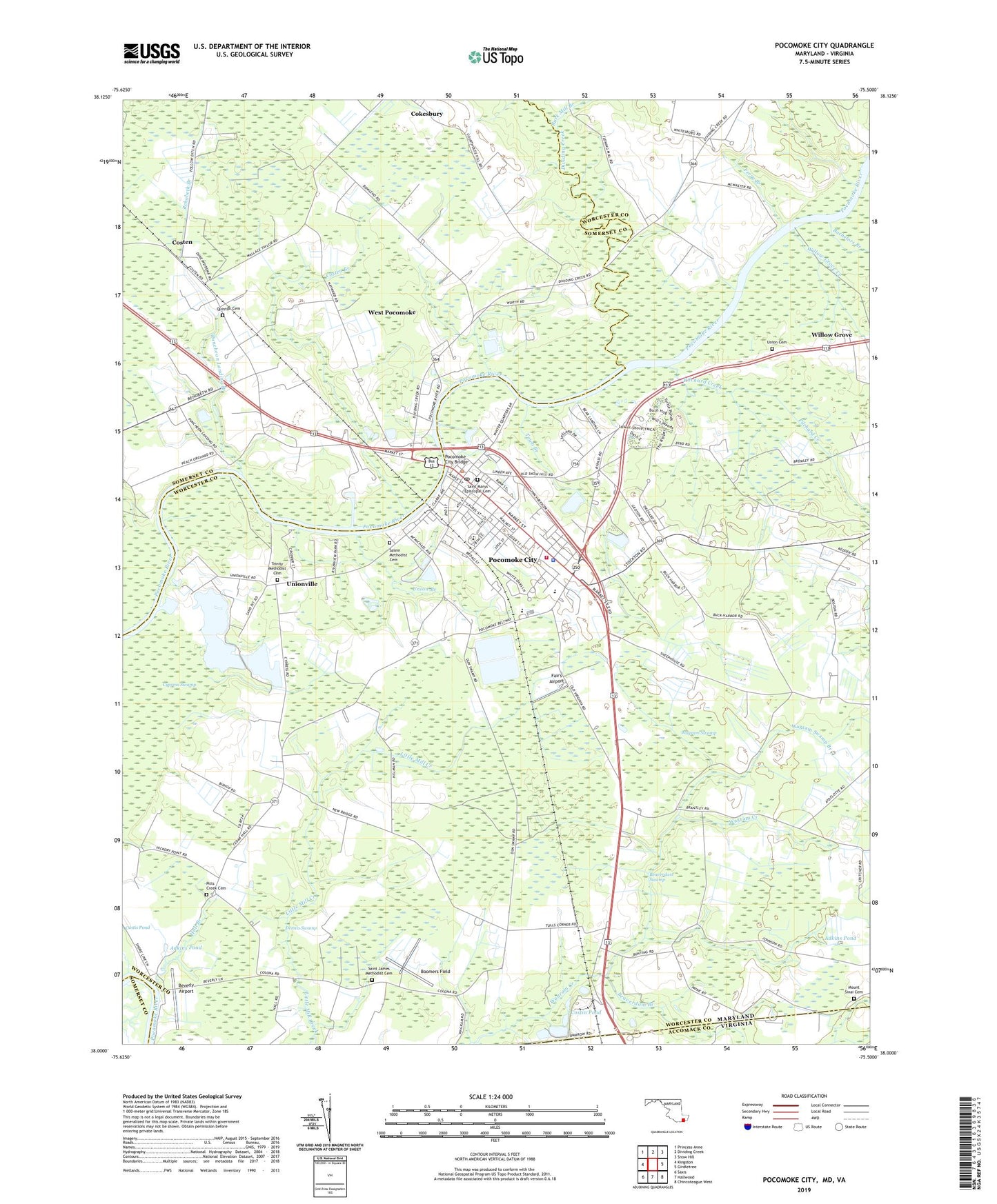
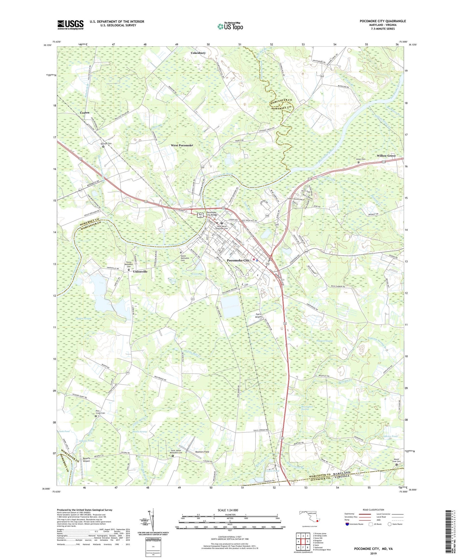
2019 topographic map quadrangle Pocomoke City in the states of Maryland, Virginia. Scale: 1:24000. Based on the newly updated USGS 7.5' US Topo map series, this map is in the following counties: Worcester, Somerset, Accomack. The map contains contour data, water features, and other items you are used to seeing on USGS maps, but also has updated roads and other features. This is the next generation of topographic maps. Printed on high-quality waterproof paper with UV fade-resistant inks.
Quads adjacent to this one:
West: Kingston
Northwest: Princess Anne
North: Dividing Creek
Northeast: Snow Hill
East: Girdletree
Southeast: Chincoteague West
South: Hallwood
Southwest: Saxis
Contains the following named places: Ames Plaza Shopping Center, Bachelors Branch, Baylis Shopping Center, Beaver Dam, Beaver Dam Church, Beaverdam Branch, Beaverdam Swamp, Bethany United Methodist Church, Beverly Airport, Boomers Field, Burk Mill Branch, Cassatt, Cedar Hall, Cedar Hall Wharf, City of Pocomoke City, Cokesbury Church, Cokesbury United Methodist Church, Costen, Costen Branch, Costen House Museum, Cottingham Ferry, Cypress Park, Dennis Swamp, District 4 Dublin, Dividing Creek, Fair's Airport, Ferry Branch, First Baptist Church of Pocomoke City, Glad Tidings Assembly of God Church, Glorious Church of the Lord Jesus Christ, Hall Branch, Harbor Acres, Hartley Hall Nursing Home, Holy Name of Jesus Church, Homewood, Lynnhaven Baptist Church, Macedonia Baptist Church, Mount Sinai Baptist Church, Mount Sinai Cemetery, Mount Sinai Church, Mount Zion United Methodist Church, New Bridge Haven, Newtown Recreation Area, Pilchard Creek, Pitts Creek, Pitts Creek Cemetery, Pitts Creek Church, Pitts Creek Presbyterian Church, Pocomoke Assembly of God Church, Pocomoke Church of God, Pocomoke City, Pocomoke City Boat Ramp, Pocomoke City Branch Library, Pocomoke City Bridge, Pocomoke City Emergency Medical Service - Station 100, Pocomoke City Hall, Pocomoke City Land Fill, Pocomoke City Post Office, Pocomoke City Sewage Lagoon Number One Dam, Pocomoke City Sewage Lagoon Number Two Dam, Pocomoke City Volunteer Fire Company - Station 100, Pocomoke Elementary School, Pocomoke High School, Pocomoke Industrial Park, Pocomoke Middle School, Pocomoke Plaza Shopping Center, Pocomoke Police Department, Pocomoke Primary School, Pocomoke Seventh Day Adventist Church, Puncheon Landing, Puncheon Landing Branch, Quinton Cemetery, Quinton Church, Saint James, Saint James Methodist Cemetery, Saint James United Methodist Church, Saint Johns African Methodist Episcopal Church, Saint Mary the Virgin Episcopal Church, Saint Marys Episcopal Cemetery, Salem Methodist Cemetery, Salem United Methodist Church, School Number 3, Tindlys Chapel, Town Branch, Trinity Church, Trinity Methodist Cemetery, Union Branch, Union Cemetery, Union Church, Unionville, Unionville Heights, Wagram Creek, Wagram Swamp, Wagram Swamp Branch, WDMV-AM (Pocomoke City), West Pocomoke, West Pocomoke Census Designated Place, Willow Grove, Willow Grove Creek, Winter Quarter Golf Course, ZIP Code: 21851