MyTopo
Point of Rocks Maryland US Topo Map
Couldn't load pickup availability
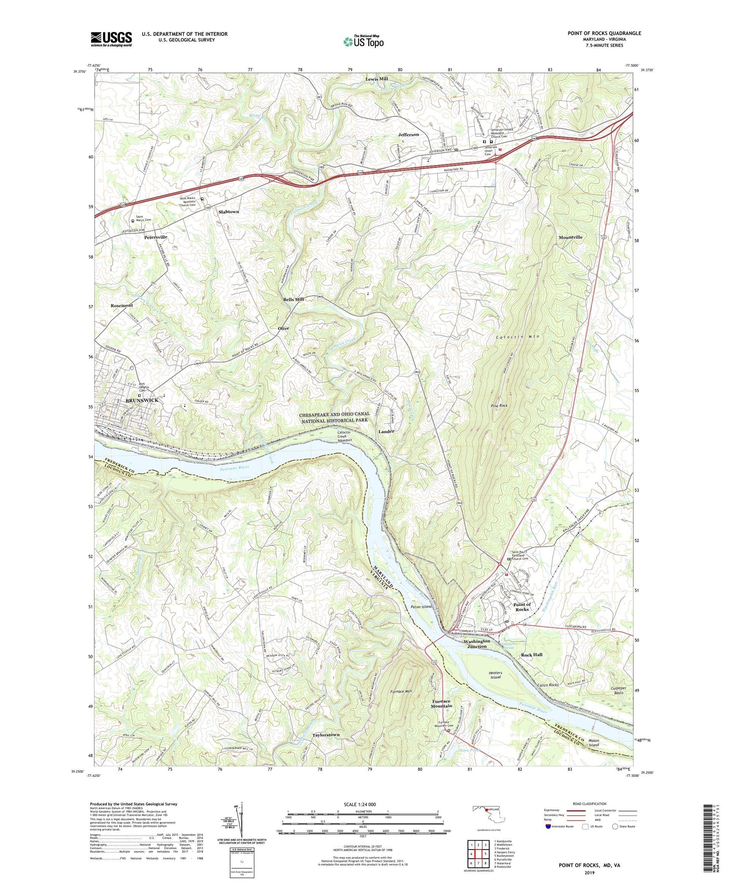
2019 topographic map quadrangle Point of Rocks in the states of Maryland, Virginia. Scale: 1:24000. Based on the newly updated USGS 7.5' US Topo map series, this map is in the following counties: Frederick, Loudoun. The map contains contour data, water features, and other items you are used to seeing on USGS maps, but also has updated roads and other features. This is the next generation of topographic maps. Printed on high-quality waterproof paper with UV fade-resistant inks.
Quads adjacent to this one:
West: Harpers Ferry
Northwest: Keedysville
North: Middletown
Northeast: Frederick
East: Buckeystown
Southeast: Poolesville
South: Waterford
Southwest: Purcellville
Contains the following named places: Adamstown Village, Bald Eagle Island Campground, Bells Mill, Bethel Lutheran Church, Boss Arnold Village, Bradbury Heights, Briercrest Heights, Broad Run, Brunswick Branch Frederick County Library, Brunswick Branch Library, Brunswick City Park, Brunswick High School, Brunswick Historic District, Brunswick Medical Center, Brunswick Middle School, Brunswick Riverside Park, Burgee, Calico Rocks, Calico Rocks Campground, Camp Kanawha, Canavest, Catoctin Creek, Catoctin Creek Aqueduct, Catoctin Point, Concord, Copperfield, District 12 Petersville, District 14 Jefferson, District 25 Brunswick, Eastwick, EcoVillage of Loudoun County, Fairview, Faith Baptist Church, Furnace Mountain, Furnace Mountain Presbyterian Cemetery, Furnace Mountain Presbyterian Church, Gapview Farm, Gore Dam, Gore Pond, Grace Episcopal Church, Heaters Island, Heaters Island Wildlife Management Area, Indian Town Landing, Jefferson, Jefferson Census Designated Place, Jefferson Court, Jefferson Heights, Jefferson Oaks, Jefferson Post Office, Jefferson Union Cemetery, Jefferson United Church of Christ, Jefferson United Methodist Church, Jefferson United Methodist Church Cemetery, Jefferson View, Jefferson Volunteer Fire and Rescue Station 20, Kanawha Spring, Lander, Lander Branch, Lewis Mill, Lewis Mill Branch, Lindsey Corner, Little Catoctin Creek, Lock Number 28, Lock Number 29, Mar-Lu-Ridge Conference and Educational Center, Mar-Lu-Ridge Vista, Mason Island, Merry Midnight, Mid View Farm, Middlebrook, Mountville, New York Hill United Methodist Church, Olive, Olive School, Park Heights Cemetery, Paton Island, Petersville, Pine Rock, Point of Rocks, Point of Rocks Assembly of God Church, Point of Rocks Census Designated Place, Point of Rocks Community Park, Point of Rocks Estates, Point of Rocks Fire Station 28, Point of Rocks Industrial Park, Point of Rocks Post Office, Point of Rocks Railroad Station, Potomac Gateway, Potomac Overlook, Potomac Village, Profit Acres, Proximity Dam, Quarter Branch, Rock Hall, Rocky Point Farm, Rosemont, Roundtree, Saint Mark's Apostolic Church Cemetery, Saint Marks Church, Saint Mary's Cemetery, Saint Marys Church, Saint Paul Lutheran Church, Saint Pauls Church, Saint Paul's Episcopal Church Cemetery, Slabtown, Slaters Crossroads, Springview, Standford Industrial Park, Stockman Estates, Sunny Side Industrial Park, Sunnyside Church, Sunrise, Taylorstown, Taylorstown Historic District, The Brunswick Shopping Center, The Jefferson School, Union Bethel Church, Valley Elementary School, Village of Rosemont, Virts, Washington Junction, Washington Run, Wilber Woods, WTRI-AM (Brunswick), ZIP Codes: 21716, 21755, 21777