MyTopo
Buckeystown Maryland US Topo Map
Couldn't load pickup availability
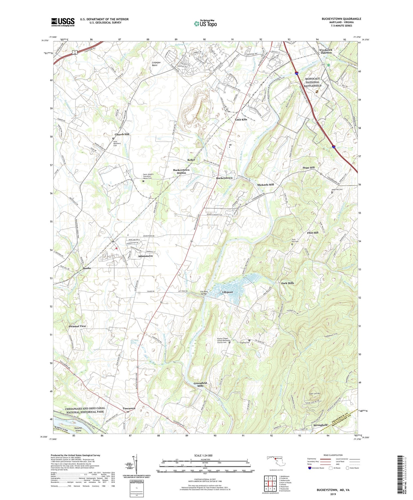
2023 topographic map quadrangle Buckeystown in the state of Maryland. Scale: 1:24000. Based on the newly updated USGS 7.5' US Topo map series, this map is in the following counties: Frederick, Montgomery, Loudoun. The map contains contour data, water features, and other items you are used to seeing on USGS maps, but also has updated roads and other features. This is the next generation of topographic maps. Printed on high-quality waterproof paper with UV fade-resistant inks.
Quads adjacent to this one:
West: Point of Rocks
Northwest: Middletown
North: Frederick
Northeast: Walkersville
East: Urbana
Southeast: Germantown
South: Poolesville
Southwest: Waterford
Contains the following named places: Adamstown, Adamstown Census Designated Place, Adamstown Post Office, Adamstown Public School, Amelung Estates, Araby United Methodist Church, Araby View, Ballenger Creek, Ballenger Creek Sewage Treatment Plant, Ballenger Heights, Bear Branch, Bells Chapel, Bennett Creek, Bowmans Plains Industrial Park, Buckeystown, Buckeystown Census Designated Place, Buckeystown Community Park, Buckeystown Historic District, Buckeystown Post Office, Buckeystown Public School, Buckeystown Station, Buckeystown United Methodist Church, Buckingham Hills, Bush Creek, Carroll Manor Elementary School, Carroll Manor Fire Company Station 14, Church Hill, Claggett Diocesan Center, Claggett Run, Country Side, District 1 Buckeystown, Doubs, Doubs Branch, Doubs School, Dudrow Industrial Park, Flint Hill, Flint Hill Cemetery, Flint Hill Methodist Church, Forest Grove Church, Frederick County Adult Detention Center, Frederick Junction, Gambrills Mill, Greenfield Acres, Greenfield Mills, Hatchery Run, Hedgeapple Farm, Hope Hill, Hope Hill Cemetery, Hope Hill United Methodist Church, Hope Valley Hills, Horsehead Run, Jehovah - Jireh Farm, Kanawah Inn, Keller, Kidwiler Farms, Kidwiler Park, Kiln Run, Koontz Chapel United Methodist Church Cemetery, Koontz Church, Lily Pons Bridge, Lily Pons Fish Ponds, Lily Pons Spring, Lily Pons Water Garden, Lilypons, Lilypons Bridge, Lilypons Post Office, Lime Kiln, Locust Run, Manor Village, Maryland Sheriffs Boys Ranch, Matovich, McKinney Industrial Park, Michaels Mill, Monocacy National Battlefield, Monocacy Overlook, Mountville Manor, Mowry, Mulberry Tree Acres, Mullinix Agro Park, New Design Acres, New Lands Corporate Park, Nolands Island, North Branch Bennett Creek, Park Mills, Paulson, Pike Branch, Pleasant View, Poplar Thicket, Potomac Farms, Potomac Farms Nursery and Greenhouses, Quarry Branch, Renn Branch Estates, Robin Meadows, Rocky Fountain Run, Saint Joseph - On - Carrollton Manor Cemetery, Saint Josephs Carrollton Manor, Saint Lukes Protestant Episcopal Church, Saint Matthew's Cemetery, Saint Matthews Church, Saint Paul Church, Saint Thomas Moore Academy, Snow Hill Dairy, South Covell, Stonewall Manor Estates, Stronghold, Sugar Loaf Mountain, Sugarloaf Estates, Sugarloaf Mountain Natural Area, Sugarloaf Mountain Vineyard, Sugarloaf West, Titus Estates, Trinity Evangelical and Reformed Church, Tuscarora, Tuscarora Elementary School, Tuscarora Post Office, Wedgewood Business Park, West Frederick Highlands, Windsor Estates, Yingling Cemetery, ZIP Codes: 21703, 21704, 21710, 21717, 21790