MyTopo
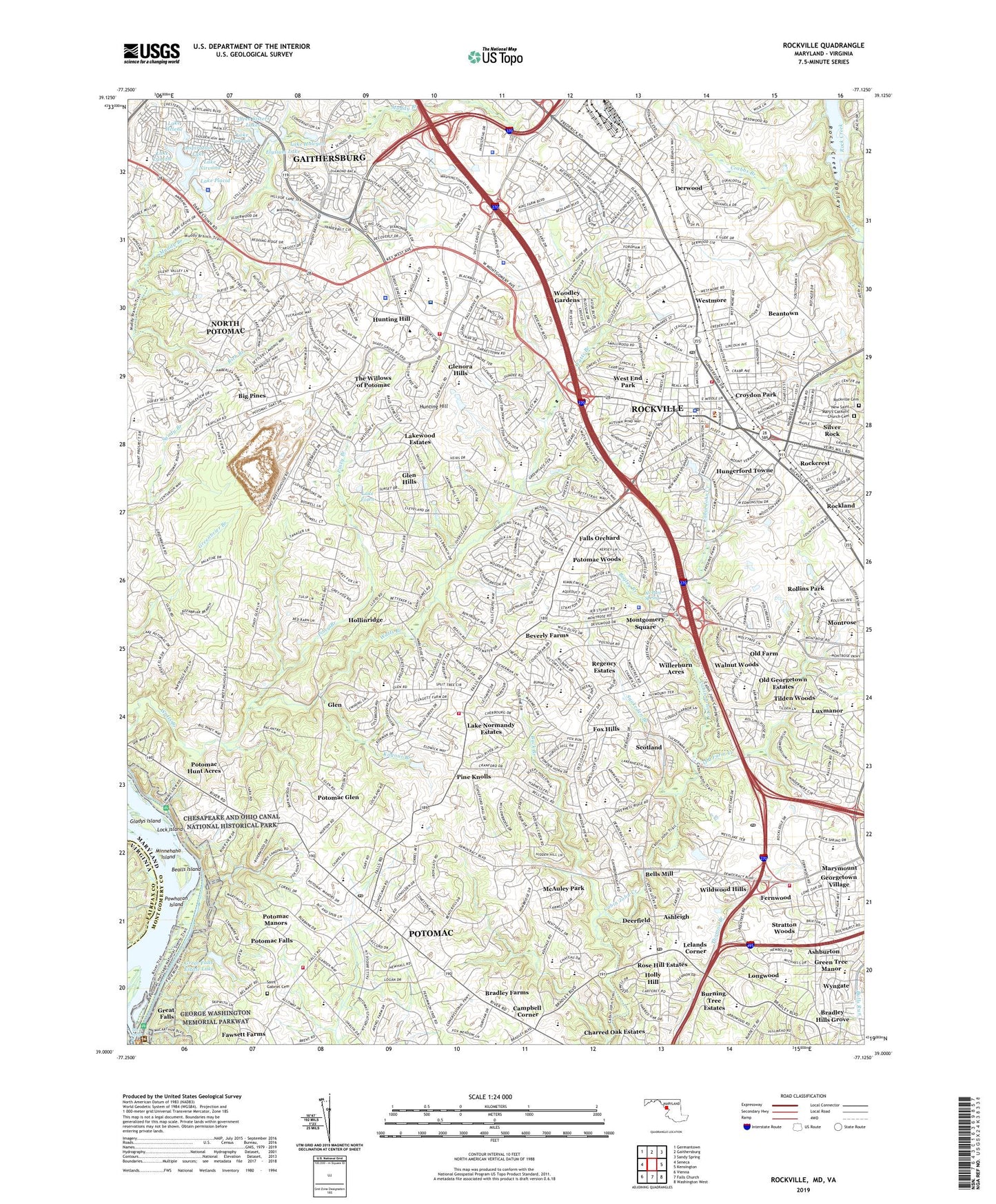
Rockville Maryland US Topo Map
Couldn't load pickup availability
2019 topographic map quadrangle Rockville in the state of Maryland. Scale: 1:24000. Based on the newly updated USGS 7.5' US Topo map series, this map is in the following counties: Montgomery, Fairfax. The map contains contour data, water features, and other items you are used to seeing on USGS maps, but also has updated roads and other features. This is the next generation of topographic maps. Printed on high-quality waterproof paper with UV fade-resistant inks.
Quads adjacent to this one:
West: Seneca
Northwest: Germantown
North: Gaithersburg
Northeast: Sandy Spring
East: Kensington
Southeast: Washington West
South: Falls Church
Southwest: Vienna
Contains the following named places: 270 Industrial Park, Adventist Healthcare Shady Grove Medical Center, Adventist Rehabilitation Hospital, All Pure Spring, Anderson Park, Ashburton, Ashburton Elementary School, Ashleigh, Bealls Island, Beantown, Bedfordshire Park, Bells Mill, Bethesda Country Club, Beverly Farms, Beverly Farms Park, Big Pines, Big Pines Park, Bogley Branch, Bradley Farms, Bradley Hills Grove, Bradley Hills Park, Buck Branch, Buck Branch Park, Bullards Park, Burning Tree Country Club, Burning Tree Estates, Cabin John Creek Stream Valley Park, Cabin John Regional Park, Campbell Corner, Carroll Branch, Center for Back Injury Prevention and Rehabilitation, Center For Repetitive Motion Disorders, Charred Oak Estates, Chestnut Lodge Sanitarium, City of Rockville, College Garden Park, College Plaza Shopping Center, Colter Industrial Park, Congressional Airport, Conn Island, Cool Spring Branch, Crabbs Branch, Crabbs Branch Park, Croydon Park, Danac Technical Industrial Park, David Scul Park, Dawson Park, Decoverly Industrial Park, Deerfield, Derwood, Derwood Census Designated Place, Derwood Industrial Park, Dicovery Industrial Park, District 10, District 4, Dogwood Park, Edison Technological Park, Elysium Lake, Falls Orchard, Falls Road Golf Course, Falls Road Park, Fallsgrove, Farmland Elementary School, Fernwood, Fernwood Park, Fortune Parc Industrial Park, Fox Hills, Franklin Office Industrial Park, Georgetown Square Shopping Center, Georgetown Village, Gladys Island, Glen, Glen Hills, Glen Hills Park, Glenora Hills, Glenora Park, Great Falls, Great Falls Estate Dam, Great Falls Estate Lake, Green Tree Manor, Greentree Park, Heritage Walk, Highland Stone Park, Hillcrest Park, Hollinridge, Holly Hill, Horizon Hill Park, Hungerford Towne, Hunting Hill, Inspiration Lake, Inspiration Lake Dam, Inverness Knolls, Israel Park, Key West Corporation Industrial Center Park, Key West Research Center Industrial Park, Kilgour Branch, Kilgour Branch Park, Knollwood, Lake Eisen, Lake Halcyon, Lake Helene, Lake Lynette, Lake Needwood, Lake Nirvana, Lake Normandy Estates, Lake Placid, Lake Placid Dam, Lake Varnuna, Lakewood Country Club, Lakewood Estates, Lelands Corner, Limekiln Branch, Lincoln Terrace Park, Lock Island, Longwood, Luxmanor Park, Marymount, Maryvale Park, McAuley Park, Metro Park North Industrial Park, Midway Center Shopping Center, Minnehaha Island, Montgomery College, Montgomery County Solid Waste Transfer Station, Montgomery Mall Shopping Center, Montgomery Square, Montrose, Montrose Office Center, Montrose Park, Montrose Woods Park, Monument Park, Muddy Branch Square Shopping Center, Needwood Estates, Needwood Golf Course, New Saint Mary's Catholic Church Cemetery, Nirvana Dam, North Congressional Plaza Shopping Center, North Farm, North Potomac Census Designated Place, Northeast Park, Old Farm, Old Farm Creek, Old Georgetown Estates, One Stop Shopping Center, Orchard Ridge Park, Pine Knolls, Piney Branch, Potomac, Potomac Census Designated Place, Potomac Falls, Potomac Glen, Potomac Hunt Acres, Potomac Manors, Potomac Place Shopping Center, Potomac Ridge Behavioral Health Treatment Center, Potomac Valley Nursing Home, Potomac Village Shopping Center, Potomac Woods, Potomac Woods Park, Powhatan Island, Red Gate Golf Course, Redgate Industrial Park, Regency Estates, Research Office Center, Research West Industrial Park, Rich Branch, Rock Spring Industrial Park, Rockcrest, Rockland, Rockmead Park, Rockshire Shopping Center, Rockville, Rockville Cemetery, Rockville Civic Center, Rockville Health Center, Rockville Metro Station, Rockville Water Plant, Rollins Park, Rose Hill Estates, Saint Gabriel Cemetery, Scotland, Shady Grove Adventist Hospital Heliport, Shady Grove Complex Industrial Center, Shady Grove Executive Center, Shady Grove Life Sciences Center, Shady Grove Medical Village, Shady Grove Metro Station, Shady Grove Music Fair Theater, Shady Grove Plaza Shopping Center, Shady Grove Shopping Center, Silver Rock, Silver Rock Park, Snakeden Branch, Stonebridge, Stratton Woods, Swains Lock, Talbott Shopping Center, The Willows of Potomac, Three Sisters Lakes, Tilden Park, Tilden Woods, Tower Oakes Industrial Park, TPC at Avenel Golf Course, Travilah Census Designated Place, Travilah Square Shopping Center, United States Postal Training Facility, Upper Rock Creek Watershed Site Number 5 Dam, Walnut Woods, Washington Center, Washington Country Club, Washington National Pike Industrial Park, Washington Science Center, Washingtonian Industrial Park, Washingtonian Woods, WCTN-AM (Potomac-Cabin John), Welsh Park, West End Park, Westmore, WGMS-AM (Bethesda), Wildwood Hills, Wildwood Medical Center, Willerburn Acres, Williamsburg Estates, Wintergreen Plaza Shopping Center, WINX Radio Station, WINX-AM (Rockville), Woodley Gardens, Woodley Gardens Park, Woodley Gardens Park Shopping Center, Woodmont Country Club, Woodmont Station Shopping Center, Wootten Mill Park, Wyngate Woods Park, ZIP Codes: 20850, 20854