MyTopo
Saint Michaels Maryland US Topo Map
Couldn't load pickup availability
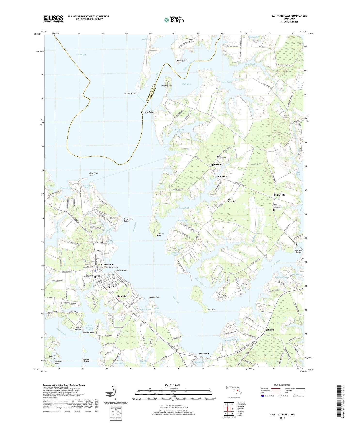
2019 topographic map quadrangle Saint Michaels in the state of Maryland. Scale: 1:24000. Based on the newly updated USGS 7.5' US Topo map series, this map is in the following counties: Talbot, Queen Anne's. The map contains contour data, water features, and other items you are used to seeing on USGS maps, but also has updated roads and other features. This is the next generation of topographic maps. Printed on high-quality waterproof paper with UV fade-resistant inks.
Quads adjacent to this one:
West: Claiborne
Northwest: Kent Island
North: Queenstown
Northeast: Wye Mills
East: Easton
Southeast: Trappe
South: Oxford
Southwest: Tilghman
Contains the following named places: All Faiths Episcopal Church, Anchorage, Arcadia Shores, Aveley, Bennett Point, Beverly Farm, Black Duck Cove, Blakes Cove, Bordley Point, Bruffs Island, Calhoon Meba Engineering School, Chapel Cove, Chesapeake Bay Maritime Museum, Christ Episcopal Church, Church Cove Park, Church Neck Point, Copperville, Cove View, Darmands Creek, Deepwater Point, DeShields Methodist Cemetery, DeShields United Methodist Church, Doncaster, Fairview Point, Frederick Douglas Elementary School, Grocelys Cove, Gross Creek, Gullwing Villas, Hambleton Cove, Hambleton Island, Hambleton Point, Harbourtown Country Club, Harper, Hayward Cove, Hells Crossing, Hopkins Point, Hunting Creek, Ingleton, Kirkham, Leeds Creek, Leeds Landing, Little Neck Creek, Lloyd Creek, Long Haul Creek, Long Point, Madison Place, Maiden Point, Martingham, Meeting House Corner, Miles River, Miles River Bridge, Miles River Ferry, Miles River Neck, Miles River Yacht Club, Mount Pleasant Farms, Mulberry Point, Navy Point, Navy Point Pier, Newcomb, Newcomb Creek, Newcomb Post Office, North Bend Estates, Parrott Point, Perry Cabin Park, Point O' Pines, Point Pleasant Farm, Porter Creek, Porters Pride, Quail Hollow, Quarter Cove, Rays Point, Rio Vista, Riverside, Roslund Farms, Saint Luke United Methodist Church, Saint Lukes Methodist Cemetery, Saint Luke's Preschool, Saint Marys Square, Saint Marys Square Museum, Saint Michael Church of God in Christ, Saint Michaels, Saint Michaels Church, Saint Michaels Elementary School, Saint Michaels Fire Department Station 40, Saint Michaels Historic District, Saint Michaels Middle High School, Saint Michaels Middle School, Saint Michaels Police Department, Saint Michaels Post Office, Saint Michaels Town Hall, Saint Michaels Village Shopping Center, Saint Stephens Graveyard, Saint Stevens Church, San Domingo Creek, Shaw Bay, Solitude, Solitude Creek, Spencer Creek, Swan Villas, Talbot County Region II Wastewater Treatment Plant, Thanksgiving, Tide Mill Cove, Todds Corner, Town of Saint Michaels, Tricfield, Trinity African Methodist Episcopal Zion Church, Tunis Mills, Union United Methodist Church, Unionville, Watch Goose Farm, Woodland Creek, Wye East River, Wye House Farm, Wye River, Wyetown Point, ZIP Codes: 21653, 21663