MyTopo
Smithsburg Maryland US Topo Map
Couldn't load pickup availability
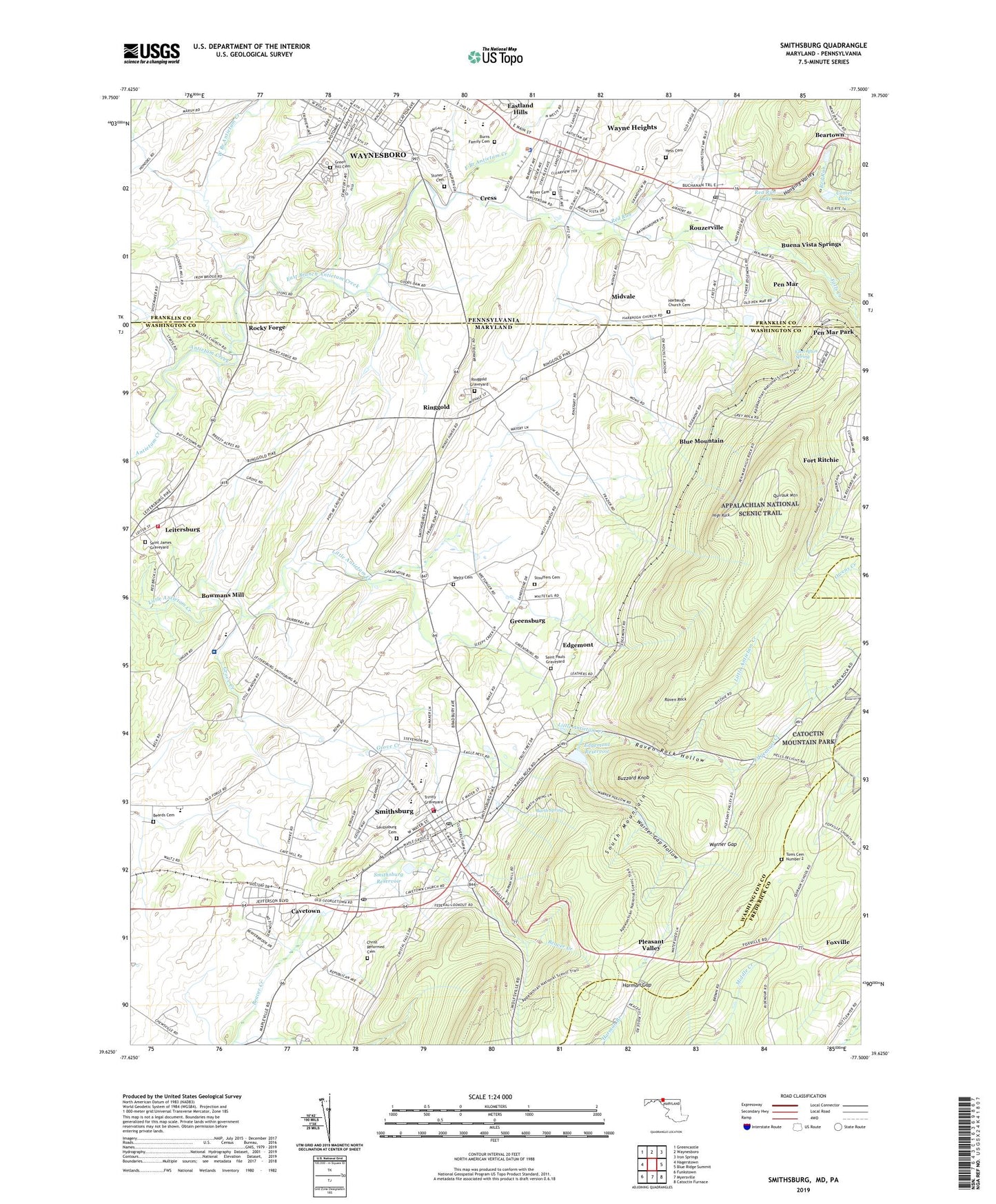
2019 topographic map quadrangle Smithsburg in the states of Maryland, Pennsylvania. Scale: 1:24000. Based on the newly updated USGS 7.5' US Topo map series, this map is in the following counties: Washington, Franklin, Frederick. The map contains contour data, water features, and other items you are used to seeing on USGS maps, but also has updated roads and other features. This is the next generation of topographic maps. Printed on high-quality waterproof paper with UV fade-resistant inks.
Quads adjacent to this one:
West: Hagerstown
Northwest: Greencastle
North: Waynesboro
Northeast: Iron Springs
East: Blue Ridge Summit
Southeast: Catoctin Furnace
South: Myersville
Southwest: Funkstown
Contains the following named places: Allenberg Orchards, Barth Spring, Beards Cemetery, Beartown, Beaverbrook, Bittner/Whitsel Airport, Blue Mountain, Blue Mountain School, Blueberry Heights, Bluegrass Estates, Bowmans Mill, Brook Lane Psychiatric Center, Buena Vista Spring Post Office, Buena Vista Springs, Burns Family Cemetery, Buzzard Knob, Camp Wohelo, Cavetown, Cavetown Census Designated Place, Cavetown Post Office, Christ Reformed Cemetery, Christ Reformed Church, Clopper Orchards, Comet Lake, Comet Lake Dam, Country Squire Estates, Cress, District 14 Ringgold, District 7 Smithsburg, Durburow Mill, East Branch Antietam Creek, Eastland Hills, Edgemont, Edgemont Census Designated Place, Edgemont Creek, Edgemont Reservoir, Falls Creek, Fort Ritchie Census Designated Place, Franklin School, Gardenhour Orchards, Glen Afton Spring, Goods Garden and Greenhouse, Green Hill Cemetery, Greensburg, Greensburg Census Designated Place, Greensburg School, Greenvale Village, Grove Creek, Hagerstown Reservoir, Hanging Valley, Harbaugh Church, Harbaugh Church Cemetery, Hardings Orchard, Harman Gap, Harrison School, Havenwood Hills, Hess Cemetery, High Rock, Hill Village, Holiday Acres, Holiday Farms, Hopkins Ridge, Ivy Hill Farm, Kemp Horn Vocational Center, Laurel Hall School - Hagerstown, Leitersburg, Leitersburg Census Designated Place, Leitersburg Volunteer Fire Company 9, Long Meadow School, Mdnoname1 Dam, Midvale, Mount Pleasant Church of God, Old Forge Elementary School, Orchard Estates, Pen Mar, Pen Mar Census Designated Place, Pen Mar Park, Pen Mar Post Office, Pleasant Valley, Pleasant Valley School, Quirauk Mountain, Raven Rock, Raven Rock Hollow, Red Run, Red Run Lake, Ringgold, Ringgold Census Designated Place, Ringgold Church, Ringgold Graveyard, Rocky Forge, Rouzerville, Rouzerville Census Designated Place, Rouzerville Post Office, Royer Cemetery, Saint Anns Episcopal Church, Saint James Graveyard, Saint James Reformed Church, Saint Paul Lutheran Church, Saint Paul United Methodist Church, Saint Pauls Graveyard, Saint Pauls Lutheran Church, Saint Peters Beard Lutheran Church, Shockeys, Smithsburg, Smithsburg Cemetery, Smithsburg Community Volunteer Fire Company 7, Smithsburg Community Volunteer Fire Company 79, Smithsburg Elementary School, Smithsburg Emergency Medical Services Company 79, Smithsburg High School, Smithsburg Middle School, Smithsburg Police Department, Smithsburg Post Office, Smithsburg Town Hall, Stoner Cemetery, Stouffers Cemetery, Stouffers Church, Strites School, Toms Cemetery Number 2, Town of Smithsburg, Township of Washington, Trinity Graveyard, Trinity Lutheran Church, Trinity Nursery School, Warner Gap, Warner Gap Hollow, Warners Gap Hollow Dam, Washington Township High School, Washington Township Police Department, Waterloo, Wayne Heights, Wayne Heights Census Designated Place, WAYZ-AM (Waynesboro), WAYZ-FM (Waynesboro), WBZT-AM (Waynesboro), Welty Church of the Brethren Cemetery, Weltys Church, West Branch Antietam Creek, Wohelo Lake Dam, WWMD-FM (Hagerstown), ZIP Codes: 17250, 21783