MyTopo
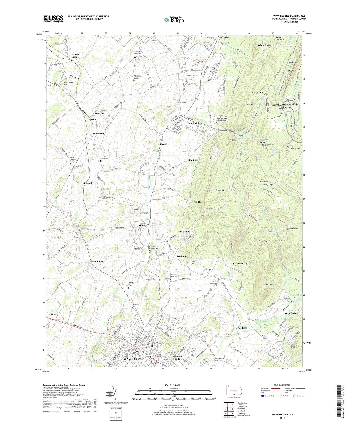
Waynesboro Pennsylvania US Topo Map
Couldn't load pickup availability
2023 topographic map quadrangle Waynesboro in the state of Pennsylvania. Scale: 1:24000. Based on the newly updated USGS 7.5' US Topo map series, this map is in the following counties: Franklin. The map contains contour data, water features, and other items you are used to seeing on USGS maps, but also has updated roads and other features. This is the next generation of topographic maps. Printed on high-quality waterproof paper with UV fade-resistant inks.
Quads adjacent to this one:
West: Greencastle
Northwest: Chambersburg
North: Scotland
Northeast: Caledonia Park
East: Iron Springs
Southeast: Blue Ridge Summit
South: Smithsburg
Southwest: Hagerstown
This map covers the same area as the classic USGS quad with code o39077g5.
Contains the following named places: Altenwald, Antietam Church Cemetery, Antietam Cove, Benedict Family Cemetery, Biesecker Gap, Biesecker Run, Blue Rock School, Bonebrake Family Cemetery, Borough of Mont Alto, Borough of Waynesboro, Brechbill Cemetery, Burns Hill Cemetery, Burns Knob, Chestnut Spring, Conboy Switch, Curve Mountain, Deer Lick Run, Eagle Rock, Elbrook, Fairview, Fairview School, Fellowship Independence Cemetery, Fetterhoff Chapel Cemetery, Fetterhoff Family Burial Ground, Five Forks, Forest School, Fox Hill, Fox Hill School, Gap School, Glen Forney, Greendale, Greendale School, Grindstone Hill, Grove Hill School, Guilford Siding, Jacob Harshman Family Cemetery, Jugtown, Knepper, Ledy, Meeting of the Pines Natural Area, Middour Farm Cemetery, Mont Alto, Mont Alto Ambulance Squad, Mont Alto Cemetery, Mont Alto Post Office, Mont Alto State Forest, Mont Alto State Park, Mont Alto Volunteer Fire Department - Company 5, Montalto Mountain, Mount Zion Cemetery, New Guilford Cemetery, Nicodemus, Nunnery, Oak Hill School, Oak Knob, Pearl Spring, Pennsylvania State University - Mount Alto Campus, Pigeon Hills School, Pine Knob, Pivot Rock, Polk Hill School, Pond Bank, Pond Bank Cemetery, Pond Bank Mennonite Cemetery, Quincy, Quincy Cemetery, Quincy High School, Quincy Mountain, Quincy Post Office, Quinsonia, Red Run, Roadside, Rocky Mountain, Round Top, Ryder School, Saint Andrew Catholic Cemetery, Sandy Ridge, Sandy Ridge Trail, Shriners Knob, Slabtown, Snow Hill Nunnery Cemetery, Snowy Mountain Vista, State Game Refuge, Tarburner Spring, The Narrows, Tomstown, Township of Quincy, Travelers Spring, Valley View Vista, Vineyard Run, Warrior Trail, Waynesboro, Waynesboro Ambulance Squad, Waynesboro Area Advanced Life Support Unit Medic 2, Waynesboro Country Club, Waynesboro Fire Department Company 2 - Station 1 Headquarters, Waynesboro Fire Department Company 2 - Station 2, Waynesboro Hospital, Waynesboro Hospital Heliport, Waynesboro Police Department, Waynesboro Post Office, Waynesboro Reservoir, White Rock School, White Rocks, Zullinger Post Office, ZIP Codes: 17237, 17247, 17261, 17268, 17272