MyTopo
Woodsboro Maryland US Topo Map
Couldn't load pickup availability
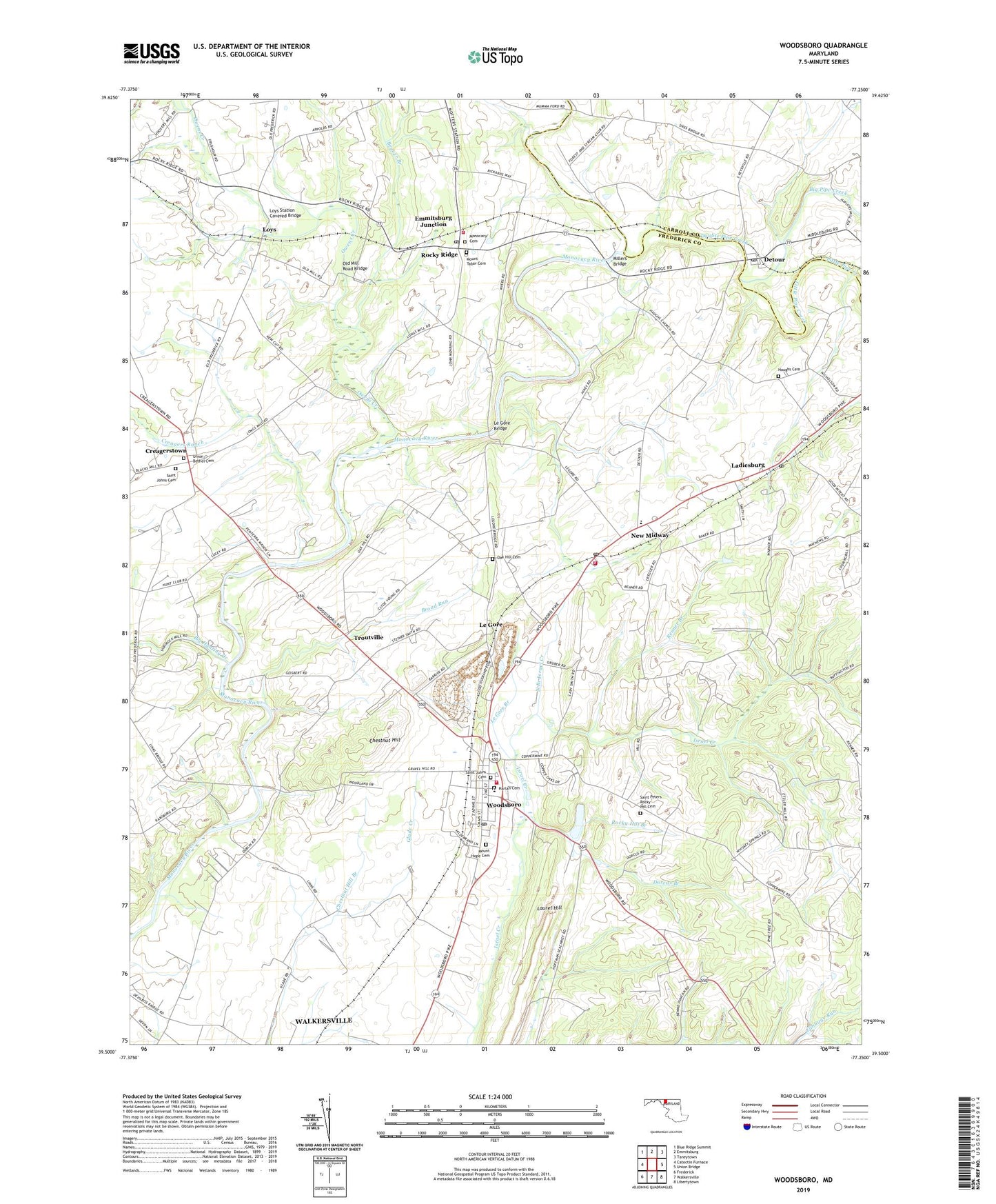
2019 topographic map quadrangle Woodsboro in the state of Maryland. Scale: 1:24000. Based on the newly updated USGS 7.5' US Topo map series, this map is in the following counties: Frederick, Carroll. The map contains contour data, water features, and other items you are used to seeing on USGS maps, but also has updated roads and other features. This is the next generation of topographic maps. Printed on high-quality waterproof paper with UV fade-resistant inks.
Quads adjacent to this one:
West: Catoctin Furnace
Northwest: Blue Ridge Summit
North: Emmitsburg
Northeast: Taneytown
East: Union Bridge
Southeast: Libertytown
South: Walkersville
Southwest: Frederick
Contains the following named places: Beaver Branch, Big Hunting Creek, Big Pipe Creek, Broad Run, Centerville, Chestnut Hill, Chestnut Hill Branch, Cookerlys Creek, Copper Oaks, Creagers Ranch, Creagerstown, Creagerstown Park, Delaplane Mill, Detour, Detour Methodist Protestant Church, Detour Post Office, Devon Farms, District 11 Woodsboro, District 4 Creagerstown, Dorcas Branch, Double Pipe Creek, Emmitsburg Junction, Fairhaven, Franklin School, Glade Creek, Glade Haven Farms, Glade Valley Golf Course, Good Hill, Grace Evangelical Lutheran Church, Grace Rocky Hill Lutheran Church Cemetery, Grooe Academy School, Harlan Cemetery, Haughs Cemetery, Haughs German Reformed Church, Haughs Hideway, Hoffman, Hunt Club Acres, Koblan, Ladiesburg, Ladiesburg Post Office, Lamberts Acres, Laurel Hill, Le Gore, Le Gore Branch, Le Gore Bridge, Le Gore Quarry, Liberty Forest, Little Pipe Creek, Lost and Gain, Loys, Loys Station Covered Bridge, Loys Station Park, Mabels Manor, Martins Mill, Meyers Ford, Meyers Mill, Midway Pines, Millers Bridge, Monocacy Cemetery, Monocacy Church of the Brethren, Monocacy Meadows, Mort Hills, Mount Hope Cemetery, Mount Tabor Cemetery, Mount Tabor United Church of Christ, Mount Zion Church, Mumma Ford, New Midway, New Midway Elementary School, New Midway Fire Company Number 9, New Midway Post Office, New Midway Volunteer Fire Company Station 9, North Branch Israel Creek, Oak Bluff Dairy Farm, Oak Hill Cemetery, Oak Hill Church, Old Bridges Creek, Old Mill Road Bridge, Owens Creek, Phylpres, Piney Hill Estates, Quarry View, Renner Branch, Resolution Farm, Rock Chapel Estates, Rocky Glade Farms, Rocky Hill Branch, Rocky Hill Church, Rocky Ridge, Rocky Ridge Estates, Rocky Ridge Park, Rocky Ridge Post Office, Rocky Ridge Volunteer Fire Company Station 13, Rosswood Estates, Saint Johns Cemetery, Saint Johns Evangelical Lutheran Church, Saint Johns Reformed Church, Sexton Farm, Sharrer Heights, Sidmar, Stovers, Stull, Stulls Ford, Sunset Acres, Swiger, Town of Woodsboro, Triple Farm, Troutville, Union Bethel Church, Union Bethel of the Church of God Cemetery, Vicmyer Vista, Wiley Mill, Wolfs Den, Woodsboro, Woodsboro Elementary School, Woodsboro Industrial Park, Woodsboro Medical Center Primary Care, Woodsboro Park, Woodsboro Post Office, Woodsboro Volunteer Fire Company Station 16, ZIP Codes: 21757, 21778, 21798