MyTopo
Milford Massachusetts US Topo Map
Couldn't load pickup availability
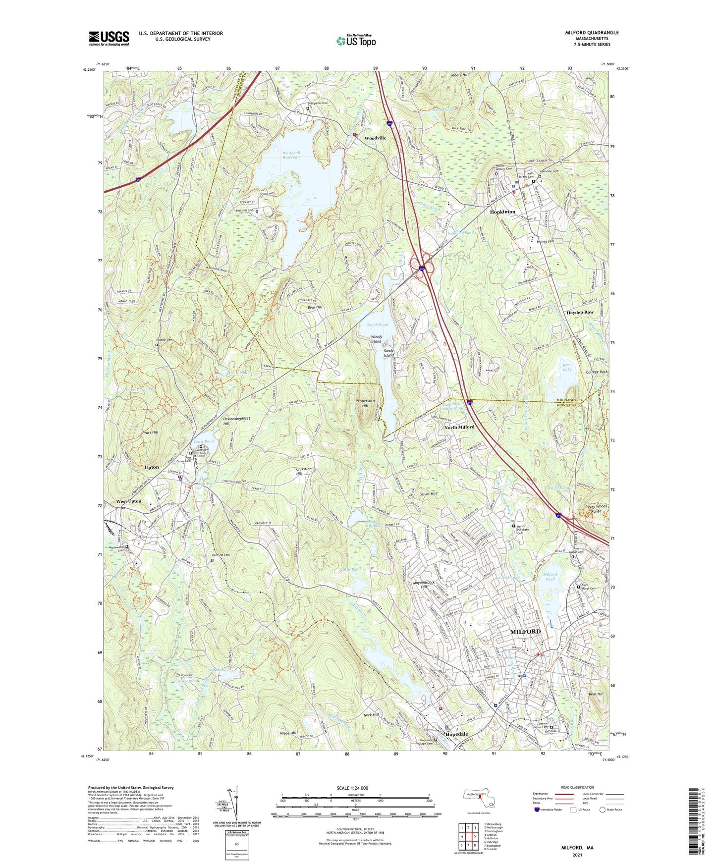
2021 topographic map quadrangle Milford in the state of Massachusetts. Scale: 1:24000. Based on the newly updated USGS 7.5' US Topo map series, this map is in the following counties: Worcester, Middlesex. The map contains contour data, water features, and other items you are used to seeing on USGS maps, but also has updated roads and other features. This is the next generation of topographic maps. Printed on high-quality waterproof paper with UV fade-resistant inks.
Quads adjacent to this one:
West: Grafton
Northwest: Shrewsbury
North: Marlborough
Northeast: Framingham
East: Holliston
Southeast: Franklin
South: Blackstone
Southwest: Uxbridge
Contains the following named places: Bahai Faith Church, Ball School, Bancroft Memorial Library, Bear Hill, Bear Hill Cemetery, Berry Acres Conservation Area, Blackstone Valley Technical High School, Bradish Cemetery, Carrigan Park, Cedar Swamp Pond, Cedar Swamp Pond Dam, Center Brook, Chapin Street School, Christ Baptist Church, Christian Hill, Commonwealth of Massachusetts, Craddock Crewes Pond, Davidson Pond, Dean Pond, Duck Pond, Dutcher Street School, Echo Lake, Echo Lake Dam, Elmwood School, Evergreen Cemetery, Fair Shopping Plaza, Fair Shopping Plaza Shopping Center, First Church of Christ Scientist, First Congregational Church, First United Methodist Church, Fiske Millpond, Fiske Millpond Dam, Full Gospel House of Prayer Church, General Draper High School, Glen Draper High School, Godfrey Brook, Goss Pond, Hayden Row, Hayes Pond, Hayes Pond Dam, Hayward Field, Hill Executive Office Park, Hills Shopping Plaza, Hills Shopping Plaza Shopping Center, Honey Hill, Hopedale, Hopedale Census Designated Place, Hopedale Fire Department, Hopedale Junior-Senior High School, Hopedale Memorial School, Hopedale Police Department, Hopedale Pond, Hopedale Pond Dam, Hopedale Post Office, Hopedale Unitarian Parish Church, Hopedale Village Cemetery, Hopinton High School, Hopkinton, Hopkinton Census Designated Place, Hopkinton Center School, Hopkinton Fire Department Headquarters, Hopkinton Fire Department Station 2, Hopkinton High School, Hopkinton Middle School, Hopkinton Police Department, Hopkinton Post Office, Hopkinton Pre-School, Hopkinton Public Library, Hopkinton Town Hall, Huckleberry Brook, Icehouse Pond, Korean Presbyterian Church, Lachary Pond, Lake Luisa Dam, Lakeview Cemetery, Louisa Lake, Magomiscock Hill, Main Street Cemetery, Maplewood Cemetery, Milford, Milford Catholic Elementary School, Milford Census Designated Place, Milford Christian School, Milford Country Club, Milford County Home, Milford Fire Department Station 1, Milford High School, Milford Memorial School, Milford Middle School East, Milford Police Department, Milford Pond, Milford Post Office, Milford Regional Medical Center, Milford Town Library, Milford-Whitinsville Regional Hospital Medical Library, Mill Pond, Mill Pond Dam, Miscoe Hill Middle School, Misoe Hill, Mount Auburn Cemetery, Neck Hill, Nipmuc Regional High School, North Milford, North Pond, North Pond Dam, North Purchase Cemetery, Ockoocanganset Hill, Old First Cemetery, Old Grist Mill Pond Dam, Old Stone Tavern, Oliver Street School, Park Street School, Peppercorn Hill, Pine Grove Cemetery, Pine Street Baptist Church, Plains School, Pratt Hill, Pratt Pond, Pratt Pond Upper Dam, Prospect Heights Historic District, Purchase Street School, Quarry Square Shopping Center, Rockwell Draper Mill Complex, Rocky Woods Range, Sacred Heart of Jesus Church, Sacred Heart Parish Church, Sacred Heart School, Saint John the Evangelist Church, Saint Marys Cemetery, Saint Marys Church, Saint Marys High School, Saint Pauls Episcopal Church, Salvation Army, Sandy Island, Shining Star Early Childhood Learning Center, Silver Hill, Stacy Middle School, Stacy School, Taft Pond, Taft Pond Brook, Temple Beth Shalom, Town of Hopkinton, Town of Milford, Town of Upton, Trinity Episcopal Church, True LIght Christian Church, Union Evangelical Church, Unitarian Church, Upper Westboro Reservoir Dam, Upton, Upton Census Designated Place, Upton Department of Emergency Medical Services, Upton Fire Department, Upton Memorial Elementary School, Upton Police Department, Upton Post Office, Valentine Cemetery, Vernon Grove Cemetery, Vineyard Church of Hopkinton, West Branch Charles River, West Street School, West Upton, Westboro Reservoir, Whitehall Reservoir, Whitehall Reservoir Dam, Whitehall State Park, Wildcat Pond, WMRC-AM (Milford), Woodville, Woodville Baptist Church, Woodville Post Office, Woody Island, ZIP Codes: 01568, 01748, 01757