MyTopo
Grafton Massachusetts US Topo Map
Couldn't load pickup availability
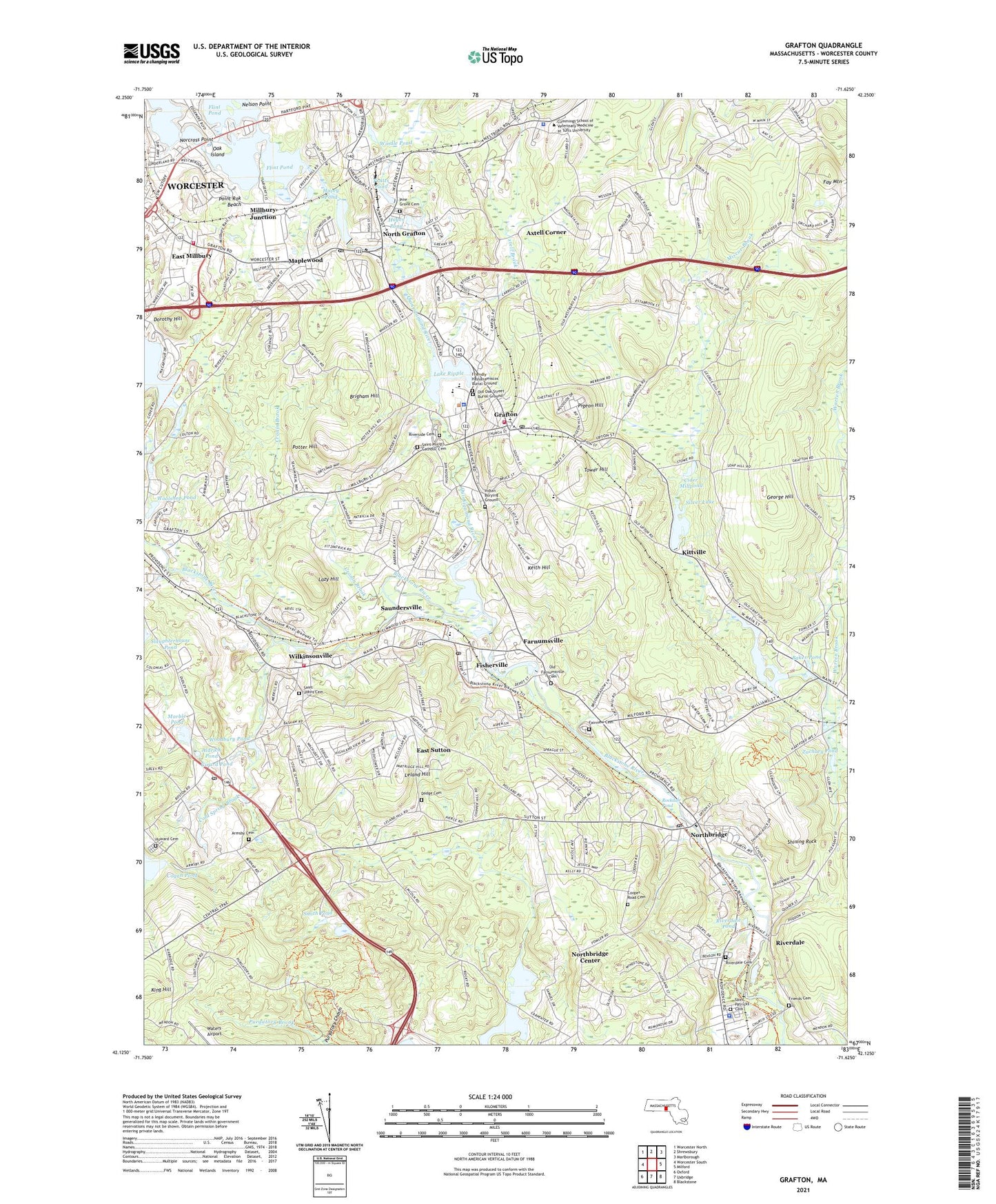
2024 topographic map quadrangle Grafton in the state of Massachusetts. Scale: 1:24000. Based on the newly updated USGS 7.5' US Topo map series, this map is in the following counties: Worcester. The map contains contour data, water features, and other items you are used to seeing on USGS maps, but also has updated roads and other features. This is the next generation of topographic maps. Printed on high-quality waterproof paper with UV fade-resistant inks.
Quads adjacent to this one:
West: Worcester South
Northwest: Worcester North
North: Shrewsbury
Northeast: Marlborough
East: Milford
Southeast: Blackstone
South: Uxbridge
Southwest: Oxford
Contains the following named places: Aldrich Pond, Armsby Cemetery, Axtell Brook, Axtell Corner, Baker Pond, Baptist Church of Grafton, Big Bummet Brook, Blackstone Canal, Blackstone River Dam, Blackstone River Reservoir, Brigham Hill, Carpenter Reservoir, Carpenter Reservoir Dam, Carpenter Reservoir Dike, Chase Road Dam, Cider Millpond, Clark Reservoir, Clark Reservoir Dam, Cogan Pond, Cold Spring Brook, Cooper Road Cemetery, Cronin Brook, Dodge Cemetery, Dorothy Hill, Dorothy Pond, Dorothy Pond Dam, East Millbury, East Sutton, Edgemere, Fairview Cemetery, Farnumsville, Farnumsville Pond Dam, Fay Mountain, Fisherville, Fisherville Pond, Fisherville Pond Dam, Fisherville School, Flint Pond, Friendly Hassanamiscos Burial Ground, Friends Cemetery, George Hill, Girard Pond, Grafton, Grafton Fire Department, Grafton Intermediate School, Grafton Memorial Senior High School, Grafton Middle School, Grafton Police Department, Grafton Post Office, Grafton State Hospital, Grafton Station, Granite Street School, Harding Street School, Hassanamisco Reservation, Hayes Pond, Hovey Dam, Hovey Pond, Howard Cemetery, Indian Burying Ground, John H Chafee Blackstone River Valley National Heritage Corridor, Keith Hill, Keown Orchard, King Hill, Kittville, Lake Quigsigamond Dam, Lake Ripple, Lake Ripple Dam 47, Lazy Hill, Leland Hill, Lower Westboro Reservoir, Lower Westboro Reservoir Dam, Maplewood, Marble Pond, Marble Pond Dam, Millbury Fire Department Station 3, Millbury Junction, Miscoe Brook, Nelson Point, Norcross Point, North Grafton, North Grafton Elementary School, North Grafton Post Office, North Grafton United Methodist Church, Northbridge, Northbridge Center, Northbridge Centre Congregational Church, Northbridge Police Department, Northbridge Post Office, Oak Island, Old Farnumsville Cemetery, Old Oak Street Burial Ground, Pigeon Hill, Pine Grove Cemetery, Point Rok Beach, Potter Hill, Pratts Pond, Pratts Pond Dam, Purgatory Chasm, Purgatory Chasm State Park, Quinsigamond River, Riverdale, Riverdale Cemetery, Riverdale Dam, Riverdale Pond, Riverside Cemetery, Rockdale Common Housing District, Rockdale Congregational Church, Rockdale Pond, Saint Andrews Episcopal Church, Saint James Parish Center, Saint Johns Cemetery, Saint Marys Church, Saint Patricks Cemetery, Saint Peters Parish Center, Saint Philip's Catholic Cemetery, Saint Phillips Church, Saint Vincent Hospital, Saundersville, Shining Rock, Shrewsbury Fire Department, Silver Lake, Silver Lake Dam, Smith Pond, South Grafton Elementary School, South Grafton Post Office, Sutton Fire Department Station 3, Sutton Post Office, Sutton State Forest, Tower Hill, Town of Grafton, Town of Northbridge, Union Congregational Church, Upton State Forest, Warren Brook, Waters Airport, Webster Veterinary Medical Library, West River Reservoir, Wildwood Lake Dam, Wilkinsonville, Willard House and Clock Museum, Windle Pond, Woodbury Pond, Woodbury Pond Dam, Woolshop Pond, Zachary Pond, ZIP Codes: 01519, 01534, 01536, 01560