MyTopo
Anoka Minnesota US Topo Map
Couldn't load pickup availability
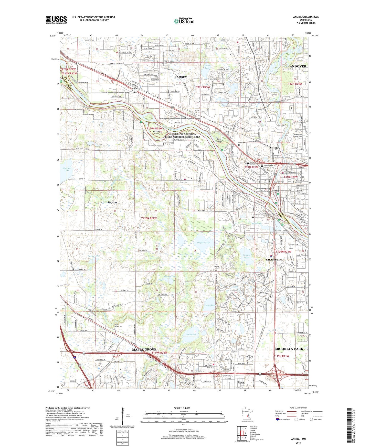
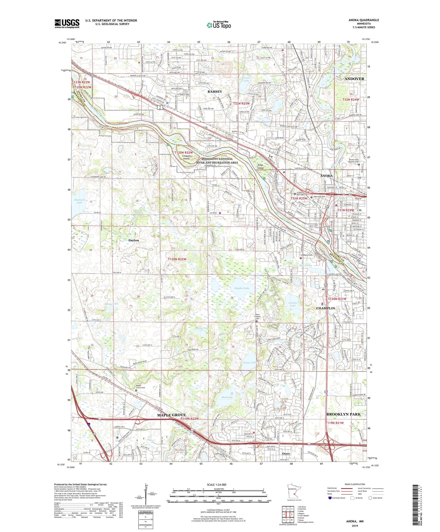
2019 topographic map quadrangle Anoka in the state of Minnesota. Scale: 1:24000. Based on the newly updated USGS 7.5' US Topo map series, this map is in the following counties: Hennepin, Anoka. The map contains contour data, water features, and other items you are used to seeing on USGS maps, but also has updated roads and other features. This is the next generation of topographic maps. Printed on high-quality waterproof paper with UV fade-resistant inks.
Quads adjacent to this one:
West: Rogers
Northwest: Elk River
North: Nowthen
Northeast: Cedar
East: Coon Rapids
Southeast: Minneapolis North
South: Osseo
Southwest: Hamel
Contains the following named places: Anoka, Anoka - Champlin Fire Department Station 1, Anoka - Champlin Fire Department Station 2, Anoka - Hennepin Sandburg Education Center, Anoka - Hennepin Technical High School, Anoka - Metro Regional Treatment Center, Anoka Church, Anoka City Hall, Anoka County Courthouse, Anoka High School, Anoka Metro Regional Technical Center, Anoka Middle School for the Arts - Fred Moore Campus, Anoka Middle School for the Arts - Washington Campus, Anoka Police Department, Anoka Post Office, Anoka State Hospital Cemetery, Bab UlIlm Islamic School, Boundary Creek Park, Calvary Cemetery, Champlin, Champlin Cemetery, Champlin City Hall, Champlin Elementary School, Champlin Library, Champlin Plaza Shopping Center, Champlin Police Department, Champlin Post Office, Charest Park, City of Anoka, City of Champlin, City of Dayton, Cloquet Island, Crossroads Alliance Church, Dayton City Hall, Dayton Elementary School, Dayton Fire Department Station 2, Dayton Police Department, Daytona Country Club, Diamond Creek, Doris A Kemp Park, Dubay Lake, Ehlen Park, Elm Creek, Elm Creek Dam, Elm Creek Elementary School, Elm Creek Park, Engles Park, Fernbrook Elementary School, Forest Hill Cemetery, Forest View Pond Park, Franklin Elementary School, Fred Moore Middle School, Gateway North Industrial Airport, Goodrich Park, Goose Lake, Grace Fellowship Church, Grass Lake, Green Park, Greenhaven Country Club, Hayden Hills Golf Course, Hayden Lake, Highland Park, Josephine Nunn Park, King Park, Kings Island, Lemans Lake, Lincoln Elementary School for the Arts, Lord of Life Church School, Maple Grove Cemetery, Maple Grove City Hall, Maple Grove Fire Department Station 3, Maple Grove Hospital, Maple Grove Senior High School, Maple Grove Senior High School - Alternative Learning Center, Maple Valley Trails, Mill Pond, Minnesota Renaissance School, Mount Olive Christian Early Childhood Center, Mount Olive School, Mud Lake, North River Park, Northland Park, Oak Creek Park, Oakwood Cemetery, PACT Charter School, Park Street Park, Peter Enich Kindergarten Center, Point Park, Powers Lake, Ramsey Elementary School, Ramsey Fire Department Station 1, Ramsey Fire Department Station 2, Ramsey Municipal Office, Ramsey Police Department, Reynolds Park, Rice Lake, Rice Lake Dam, Richardson Park, River Bend Park, Rum River, Rum River Dam, Rum River Park, Rush Creek, Saint Fridolin Cemetery, Saint Stephen's Catholic School, Schmidt State Wildlife Management Area, Sundance Golf Club, Township of Anoka, Ward Park, Wethern Park, Zachary Square Shopping Center, ZIP Codes: 55316, 55327, 55369