MyTopo
Hamilton North Montana US Topo Map
Couldn't load pickup availability
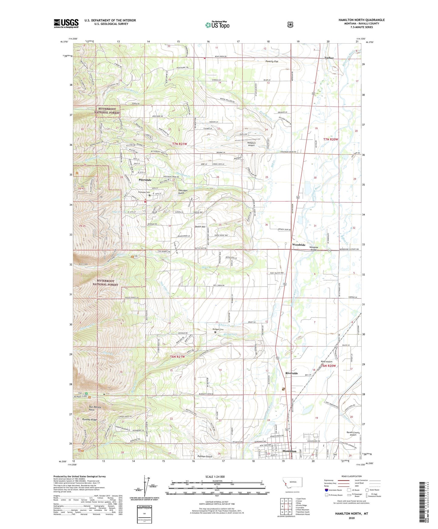
2020 topographic map quadrangle Hamilton North in the state of Montana. Scale: 1:24000. Based on the newly updated USGS 7.5' US Topo map series, this map is in the following counties: Ravalli. The map contains contour data, water features, and other items you are used to seeing on USGS maps, but also has updated roads and other features. This is the next generation of topographic maps. Printed on high-quality waterproof paper with UV fade-resistant inks.
Quads adjacent to this one:
West: Printz Ridge
Northwest: Gash Point
North: Victor
Northeast: Bing
East: Corvallis
Southeast: Mountain House
South: Hamilton South
Southwest: Ward Mountain
Contains the following named places: 06N20W05BCCC01 Well, 06N20W06DD__01 Well, 06N20W17BBCA01 Well, 06N20W19CC__01 Well, 06N20W19CCCC02 Well, 06N21W01CA__01 Well, 06N21W02BA__01 Well, 06N21W02DD__01 Well, 06N21W10CBB_01 Well, 06N21W11AABB01 Well, 06N21W11ABAA01 Well, 06N21W11DCCA01 Well, 06N21W12DB__01 Well, 06N21W12DBDA01 Well, 06N21W13CCCD01 Well, 06N21W14BDAC01 Well, 06N21W14DAAD01 Well, 06N21W15CDDD01 Well, 06N21W21ADDB01 Well, 06N21W22BCCA01 Well, 06N21W22CACA01 Well, 06N21W23ADAA01 Well, 06N21W23BABB01 Well, 06N21W23BDDD01 Well, 06N21W23CBCB01 Well, 06N21W23CDCB01 Well, 06N21W23DADA01 Well, 06N21W23DADD01 Well, 06N21W23DDAA01 Well, 06N21W23DDAD01 Well, 06N21W23DDBB01 Well, 06N21W23DDCB01 Well, 06N21W23DDDA01 Well, 06N21W24BAAC01 Well, 06N21W24CB__01 Well, 06N21W24CCAC01 Well, 06N21W24CCBB01 Well, 06N21W24CCBB02 Well, 06N21W24CCCB01 Well, 06N21W24DA__01 Well, 06N21W24DADA01 Well, 06N21W25AA__01 Well, 06N21W26AADD01 Well, 06N21W26ABAD01 Well, 06N21W26BBCA01 Well, 06N21W27BABA01 Well, 07N20W18ABBD01 Well, 07N20W18BB__01 Well, 07N20W19BA__01 Well, 07N20W30BB__01 Well, 07N20W31BB__01 Well, 07N21W13BBAD01 Well, 07N21W22BBAC01 Well, 07N21W22BBDB01 Well, 07N21W23ADB_01 Well, 07N21W25CAB_01 Well, 07N21W34CDB_01 Well, 07N21W35DAC_01 Well, 07N21W36DD__01 Well, 07N21W36DD__03 Well, 59841, Bela, Big Sky Eye Care Clinic and Optical, Bitter Root Baptist Church, Blodgett Canyon Campground, Blodgett Cemetery, Blodgett Creek, Blodgett Creek Trailhead, Blodgett Park, Blodgett Park Recreation Site, Cantonment Stevens, Christ Center, Church of Christ, Churn Creek, City of Hamilton, Cow Creek, Cow Creek Picnic Area, Daly, Daly Mansion, Discovery Care Centre, Discovery School, Don Mackey Point, Dutch Hill, Dutch Hill School, First Christian Church, Fred Burr Creek, Gird Creek, Girds Creek Post Office, Hedditch Airport, Johnson, Kimp Airport, KLYQ-AM (Hamilton), Marcus Daly Mansion Historical Marker, Mill Creek, Montana Neck and Back Pain Clinic, Mountain View Trailer Court, North West Mobile Home Park, Pines Academy, Pinesdale, Pinesdale Cemetery, Pinesdale Post Office, Pinesdale Volunteer Fire Department, Poverty Flat, Putman Gulch, Ravalli County Airport, Ravalli County Fairgrounds, Ricketts Memorial Museum, Riverside, Riverside Post Office, Riverside RV Park, Rocky Mountain Laboratory Historical Marker, Sage Creek, Sand Flower Mini Shops, Sheafman Creek, Sheridan Gulch, Shilo Christian Retreat Fellowship, Tag Alder Creek, Tamarack Creek, Town of Pinesdale, Tucker, Tucker Crossing West Fishing Access Site, Valley Baptist Church, Victor Fire Department Station 2 - Bear Creek, Willow Creek, Woodside, Woodside Bridge, Woodside Bridge Fishing Access Site, Woodside Crossing, Woodside Mennonite Church, Woodside Post Office