MyTopo
Forked River New Jersey US Topo Map
Couldn't load pickup availability
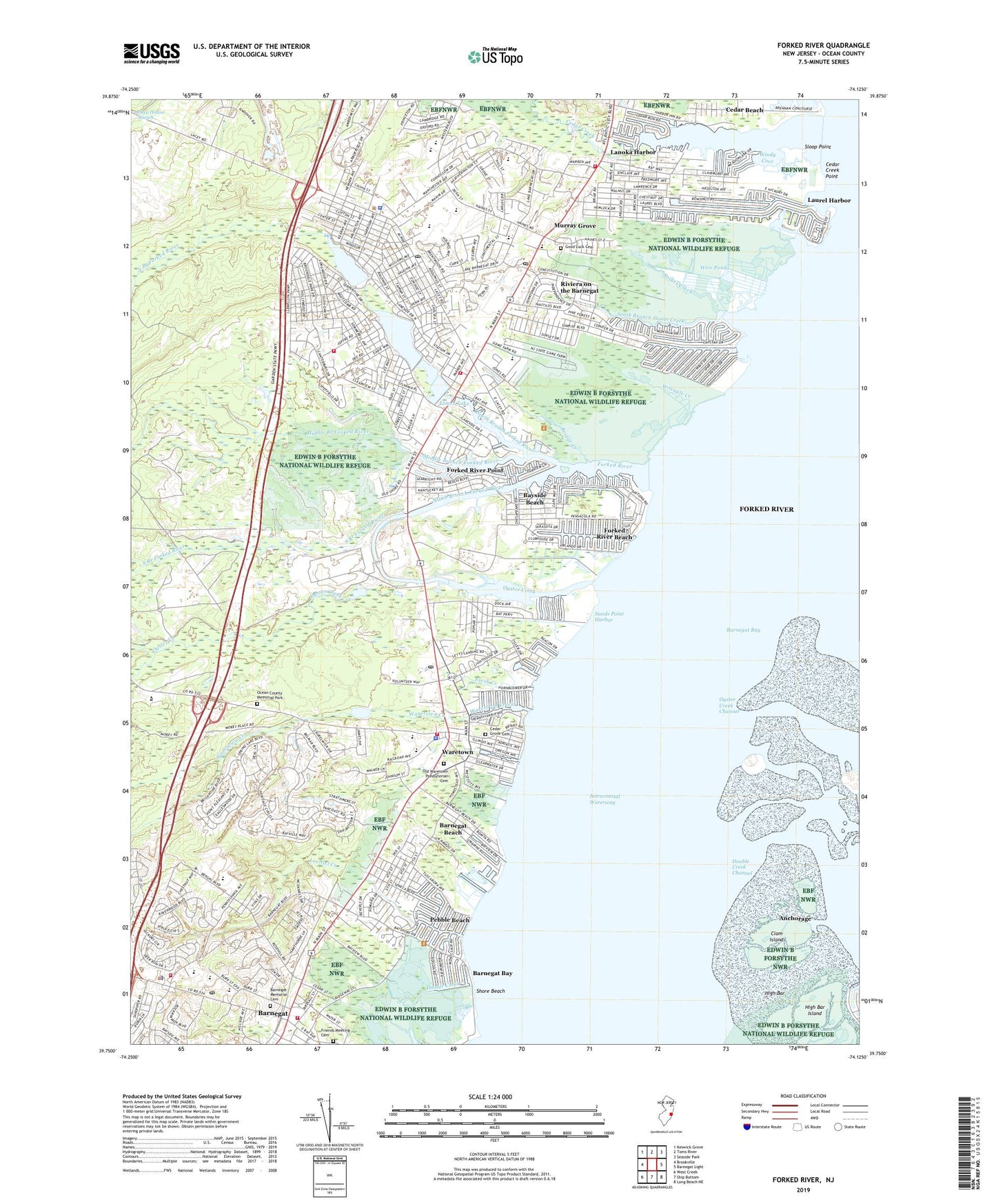
2019 topographic map quadrangle Forked River in the state of New Jersey. Scale: 1:24000. Based on the newly updated USGS 7.5' US Topo map series, this map is in the following counties: Ocean. The map contains contour data, water features, and other items you are used to seeing on USGS maps, but also has updated roads and other features. This is the next generation of topographic maps. Printed on high-quality waterproof paper with UV fade-resistant inks.
Quads adjacent to this one:
West: Brookville
Northwest: Keswick Grove
North: Toms River
Northeast: Seaside Park
East: Barnegat Light
Southeast: Long Beach NE
South: Ship Bottom
Southwest: West Creek
Contains the following named places: Barnegat, Barnegat Bay, Barnegat Beach, Barnegat Census Designated Place, Barnegat First Aid Squad, Barnegat High School, Barnegat Memorial Cemetery, Barnegat Post Office, Barnegat Township Police Department, Barnegat Volunteer Fire Company 1, Barnegat Volunteer Fire Company 1 Station 11 - 1, Bayside Beach, Berkeley Island County Park, Bridge Creek, Cecil S Collins Elementary School, Cedar Beach, Cedar Creek, Cedar Creek Elementary School, Cedar Creek Point, Cedar Grove Cemetery, Clam Island, Cranberry Hill, Daniels Bridge, Deer Head Lake, Deer Head Lake Dam, Double Creek Channel, Edwin B Forsythe National Wildlife Refuge, Forked River, Forked River Beach, Forked River Census Designated Place, Forked River Elementary School, Forked River Fire Department Headquarters, Forked River Fire Department Substation, Forked River Heliport, Forked River Point, Forked River Post Office, Forked River Presbyterian Church, Forked River State Game Farm, Frederic A Priff Elementary School, Fresh Creek, Friends Meeting Cemetery, Gille Park, Glen Cedars, Good Luck Cemetery, High Bar, High Bar Island, Holiday Beach, Lacey Business Park, Lacey Township Emergency Medical Services, Lacey Township High School, Lacey Township Middle School, Lacey Township Police Department, Lake Barnegat, Lake Barnegat Dam, Lanoka Harbor, Lanoka Harbor Elementary School, Lanoka Harbor Emergency Medical Services, Lanoka Harbor Post Office, Lanoka Harbor Volunteer Fire Department, Laurel Harbor, Liberty Harbor, Lochiel Creek, Lower Lake, Middle Branch Forked River, Mill Pond Elementary School, Murray Grove, North Branch Forked River, North Harbor, Ocean Center Vocational School, Ocean County, Ocean County Fire and First Aid Training Center, Ocean County Memorial Park, Ocean Residential Group Center, Ocean Township Police Department, Old Waretown Presbyterian Cemetery, Oyster Creek, Oyster Creek Channel, Oyster Creek Nuclear Generating Station, Oyster Creek Nuclear Power Plant, Parkside Drive Park, Pebble Beach, Riviera on the Barnegat, Robert L Horbelt Elementary School, Russell O Brackman Middle School, Saint Lukes Church, Saint Pius X Catholic Church, Sands Point Harbor, Shore Beach, Sloop Point, South Branch Forked River, South Branch Stouts Creek, South Harbor, Stouts Creek, Sunrise Beach, The Education Academy Day School, Township of Ocean, Village Lutheran Church, Vincent Clune Park, Waretown, Waretown Census Designated Place, Waretown Creek, Waretown Elementary School, Waretown First Aid Squad, Waretown Harbor, Waretown Junction, Waretown Post Office, Waretown Volunteer Fire Company 1, William Hebrew Park, Windy Cove, Wire Creek, Wire Pond, WJRZ-FM (Manahawkin), WQNJ-FM (Ocean Acres), Wrangle Creek, ZIP Codes: 08734, 08758