MyTopo
Jamesburg New Jersey US Topo Map
Couldn't load pickup availability
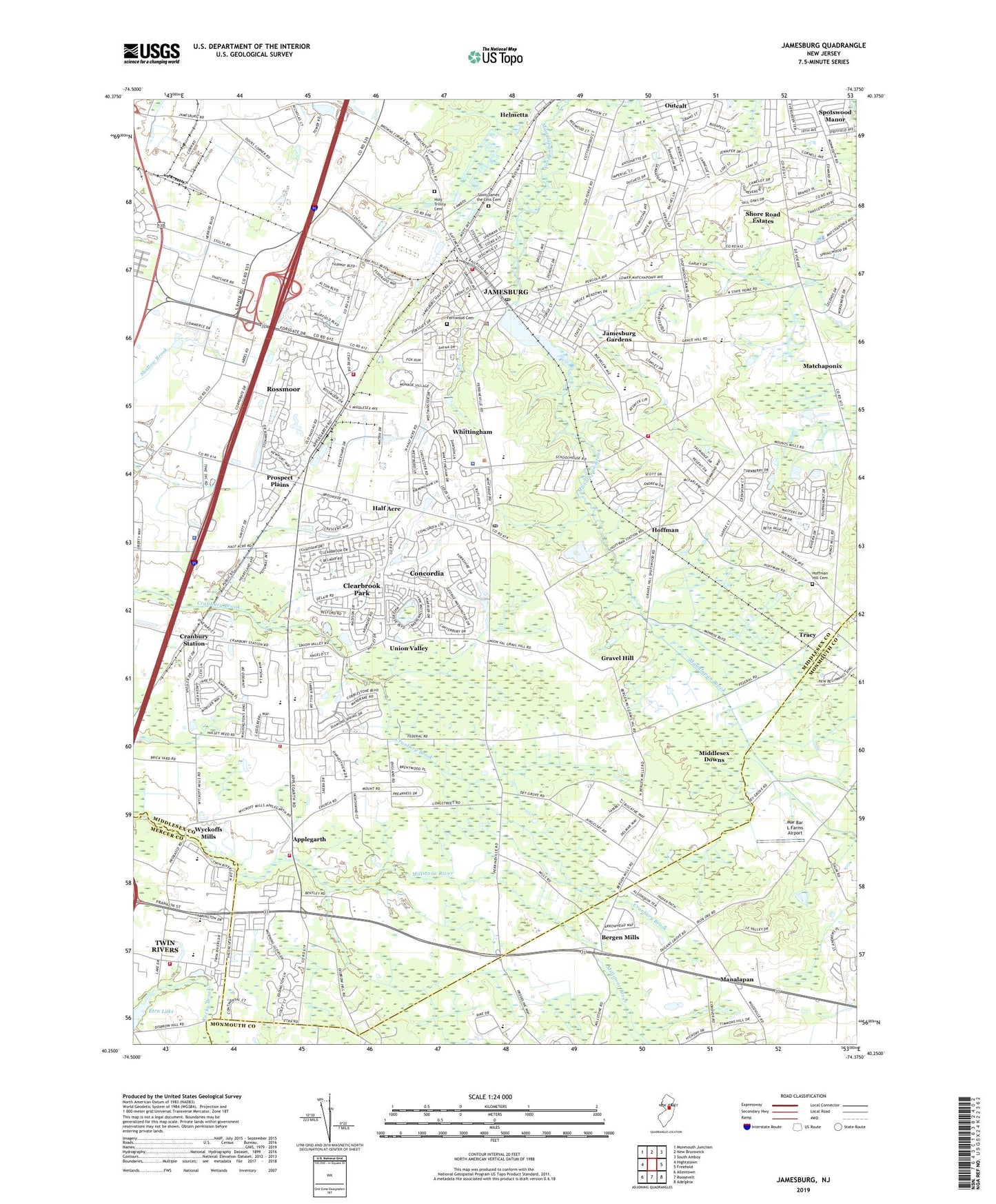
2019 topographic map quadrangle Jamesburg in the state of New Jersey. Scale: 1:24000. Based on the newly updated USGS 7.5' US Topo map series, this map is in the following counties: Middlesex, Monmouth, Mercer. The map contains contour data, water features, and other items you are used to seeing on USGS maps, but also has updated roads and other features. This is the next generation of topographic maps. Printed on high-quality waterproof paper with UV fade-resistant inks.
Quads adjacent to this one:
West: Hightstown
Northwest: Monmouth Junction
North: New Brunswick
Northeast: South Amboy
East: Freehold
Southeast: Adelphia
South: Roosevelt
Southwest: Allentown
Contains the following named places: Academy Learning Center School, Applegarth, Applegarth Middle School, Applegarth Volunteer Engine Company Number 1, Barclay Brook Elementary School, Bergen Mills, Borough of Jamesburg, Brookside Elementary School, Clearbrook, Clearbrook Census Designated Place, Clearbrook Park, Concordia, Concordia Census Designated Place, Cranbury Station, East Windsor Rescue Squad, East Windsor Township Rescue Squad District 2, East Windsor Volunteer Fire Company 2, Encore at Monroe, Encore at Monroe Census Designated Place, Ethel McKnight Elementary School, Etra Lake, Etra Park, Fernwood Cemetery, Forsgate, Forsgate Census Designated Place, Forsgate Country Club, Forsgate Industrial Complex, Grace M Breckwedel Middle School, Gravel Hill, Half Acre, Heller Industrial Park, Hoffman, Hoffman Hill Cemetery, Holy Trinity Cemetery, Jamesburg, Jamesburg Fire Department, Jamesburg First Aid Squad, Jamesburg Gardens, Jamesburg Police Department, Jamesburg Post Office, John F Kennedy Elementary School, Lake Manalapan, Manalapan, Manalapan Lake Dam, Mar Bar L Farms Airport, Matchaponix, Middlesex Downs, Mill Lake Elementary School, Monroe Manor, Monroe Manor Census Designated Place, Monroe Municipal Ambulance, Monroe Township Fire Department Administration, Monroe Township Fire District #3 Station 23b, Monroe Township Fire District 3 Station 23A, Monroe Township Middle School, Monroe Township Police Department, Monroe Township Post Office, Montessori Family School, New Jersey State Police Station Cranbury, New Jersey Training School for Boys, Old Church, Perry L Drew Elementary School, Pine Grove Camps, Presbyterian Church of Jamesburg, Prospect Plains, Regency at Monroe, Regency at Monroe Census Designated Place, Renaissance at Monroe, Renaissance at Monroe Census Designated Place, Rossmoor, Rossmoor Census Designated Place, Rossmoor Golf Course, Saint James Roman Catholic Church, Saint James the Less Cemetery, Saint John's Baptist Church, Shalom Torah Academy School, Shore Road Estates, Stonebridge, Stonebridge Census Designated Place, The Ponds, The Ponds Census Designated Place, Thompson Park, Timber Run, Township of Monroe, Township School Number 1, Township School Number 2, Tracy, Twin Rivers, Twin Rivers Census Designated Place, Union Valley, Warner-Lambert, Whittingham Census Designated Place, Wyckoffs Mills, ZIP Codes: 08810, 08831