MyTopo
Long Branch East New Jersey US Topo Map
Couldn't load pickup availability
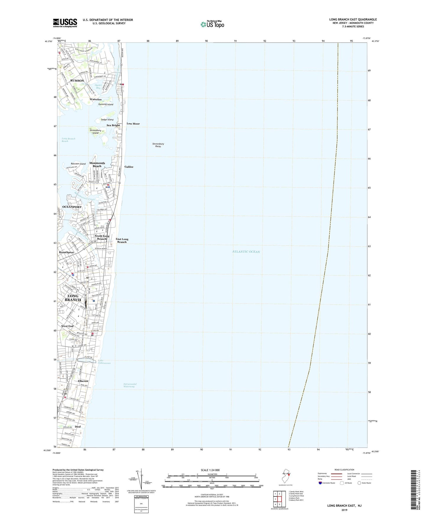
2019 topographic map quadrangle Long Branch East in the state of New Jersey. Scale: 1:24000. Based on the newly updated USGS 7.5' US Topo map series, this map is in the following counties: Monmouth. The map contains contour data, water features, and other items you are used to seeing on USGS maps, but also has updated roads and other features. This is the next generation of topographic maps. Printed on high-quality waterproof paper with UV fade-resistant inks.
Quads adjacent to this one:
West: Long Branch West
Northwest: Sandy Hook West
North: Sandy Hook East
South: Asbury Park OE E
Southwest: Asbury Park
Contains the following named places: Amerigo A Anastasia Elementary School, Asbury United Methodist Church, Atlantic Fire Engine and Truck Company 2, Audrey W Clark Elementary School, Borough of Monmouth Beach, Borough of Sea Bright, Branchport, Branchport Creek, Channel Club Tower, Chel Yaacob Congregation, Children of the King Academy School, Church of the Precious Blood, City of Long Branch, Congregation Brothers of Israel, East Long Branch, East Long Branch Station, Elberon, Elberon Elementary School, Elberon First Aid and Emergency Squad, Elberon Memorial Church, Elberon Park, Elberon Post Office, Galilee, Garfield Park, Grauman Towers, Gregory Elementary School, Gunning Island, Holy Cross Church, Holy Cross Elementary School, Holy Cross School, Holy Temple Church of God, Holy Trinity Elementary School, Ilan High School, Imperial House, Intermedial School, Jerry Morgan Park, Joseph M Ferraina Early Childhood Learning Center School, Kennedy Towers, Lake Takanassee, Lenna W Conrow Elementary School, Living Hope Fellowship Church, Long Branch, Long Branch Church of God, Long Branch Covenant Church, Long Branch Fire Department Headquarters, Long Branch Fire Department Station 25 - 3 - 75 Elberon Engine Company 4, Long Branch Fire Department Station 25 - 7 Oliver Byron Engine Company, Long Branch Fire Department Station 25 - 975 West End Engine Company 9 and Water Rescue 88, Long Branch Fire Prevention, Long Branch First Aid Squad, Long Branch High School, Long Branch High School Annex, Long Branch Middle School, Long Branch Police Department, Long Branch Post Office, Long Branch Reach, Low Moor, Manahassett Creek, Marathon Dance Pier, McLaughlin Pentecostal Faith Church, Monmouth Beach, Monmouth Beach Club, Monmouth Beach Elementary School, Monmouth Beach Emergency Medical Squad, Monmouth Beach Fire Department, Monmouth Beach Police Department, Monmouth Beach Post Office, Monmouth Medical Center, Morris Avenue School, North Long Branch, Oyster Bay, Pleasure Bay, Pleasure Bay Park, Poplar Brook, Raccoon Island, Rumson, Rumson Volunteer Fire Company Station 42 - 2, Saint George's By The River Church, Saint James Church, Saint James Episcopal Church, Saint Michaels Roman Catholic Church, Saint Peters Church, Saint Stepanos Armenian Church, Salem Baptist Church, School Number 3, Sea Bright, Sea Bright Emergency Medical Services Squad, Sea Bright Fire Rescue, Sea Bright Police Department, Sea Bright United Methodist Church, Sea Bright Village Post Office, Seashore School, Second Baptist Church, Sedge Island, Seven Presidents Park, Shrewsbury Bay, Shrewsbury Island, Shrewsbury Rocks, Spanish Pentecostal Church, Specialty Hospital at Monmouth, Star of the Sea Church, Takanassee Lake Park, Temple Beth Miriam, The Power of Christs Gospel Academy, Trinity African Methodist Episcopal Church, Troutmans Creek, Waterloo, West End, West End Elementary School, West End Post Office, Whale Pond Brook, WZVU-FM (Long Branch), ZIP Codes: 07740, 07750