MyTopo
Sandy Hook West New Jersey US Topo Map
Couldn't load pickup availability
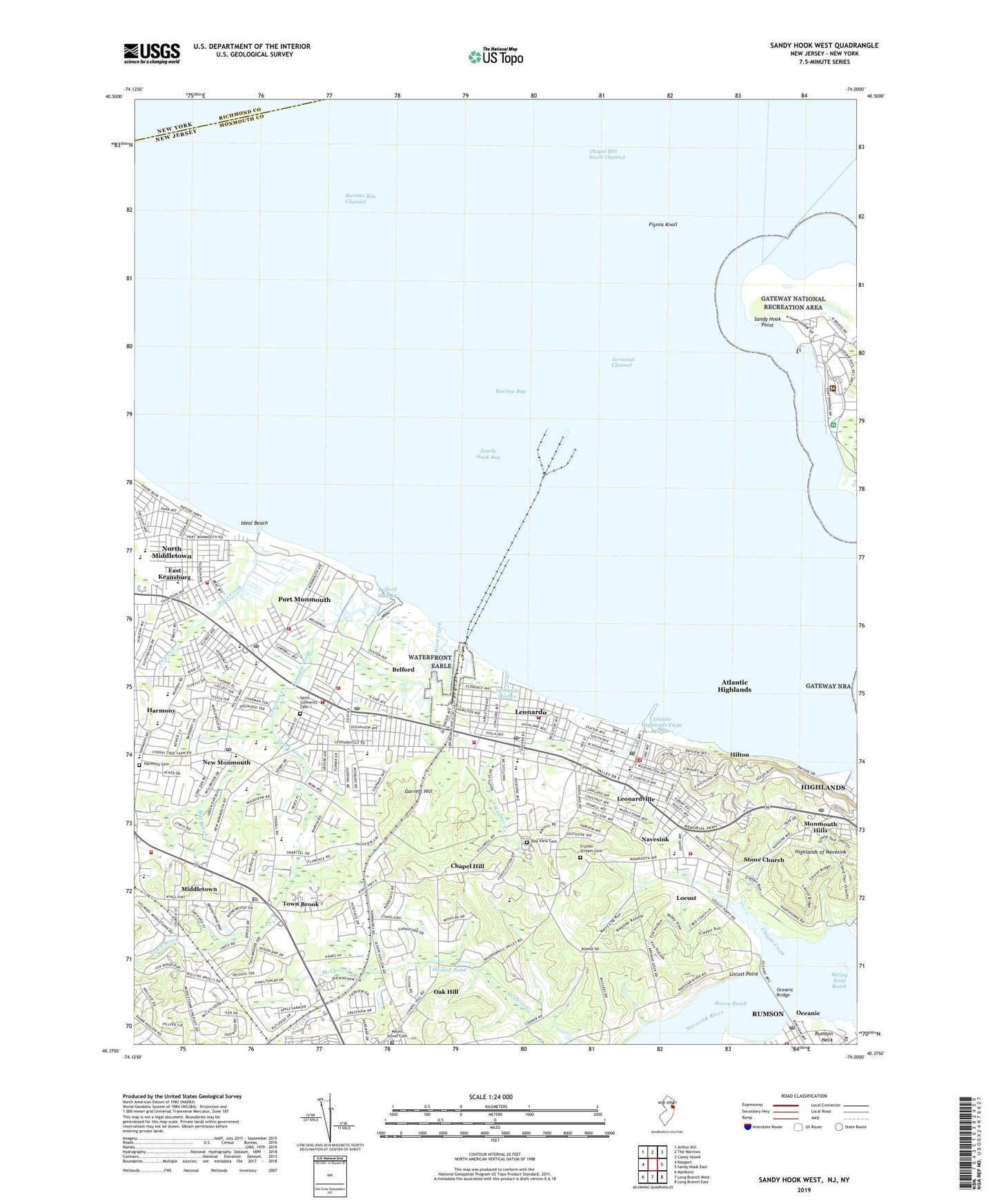
2023 topographic map quadrangle Sandy Hook West in the state of New Jersey. Scale: 1:24000. Based on the newly updated USGS 7.5' US Topo map series, this map is in the following counties: Monmouth, Richmond. The map contains contour data, water features, and other items you are used to seeing on USGS maps, but also has updated roads and other features. This is the next generation of topographic maps. Printed on high-quality waterproof paper with UV fade-resistant inks.
Quads adjacent to this one:
West: Keyport
Northwest: Arthur Kill
North: The Narrows
Northeast: Coney Island
East: Sandy Hook East
Southeast: Long Branch East
South: Long Branch West
Southwest: Marlboro
Contains the following named places: All Saints Memorial Episcopal Church, Atlantic Highlands, Atlantic Highlands Elementary School, Atlantic Highlands Fire Department, Atlantic Highlands Fire Department - Administration, Atlantic Highlands Police Department, Atlantic Highlands Post Office, Atlantic Highlands Yacht Harbor, Austin Academy School, B E S T Academy School, Barley Point Reach, Battery Alexander, Battery Arrowsmith, Battery Bloomfield, Battery Engle, Battery Granger, Battery Halleck, Battery McCook, Battery Morris, Battery Peck, Battery Reynolds, Battery Richardson, Battery Urmston, Bay View Cemetery, Bayshore Middle School, Bayshore Waterfront County Park, Bayside Community Church, Bayview Elementary School, Beacon Hill Country Club, Belford, Belford Airport, Belford Census Designated Place, Belford Harbor, Belford Post Office, Belford United Methodist Church, Bicentennial Park, Board of Proprietors State Historic Site, Borough of Atlantic Highlands, Central Baptist Church, Chapel Hill, Claypit Creek, Coast Guard Station Sandy Hook, Compton Creek, Croydon Hall School, Crystal Stream Cemetery, East Keansburg, Fairview First Aid Squad, First Presbyterian Church, First United Methodist Church, Flynns Knoll, Fort Hancock, Garrett Hill, Gordon Court Park, Greeley Park, Harbour View Tower, Harmony, Harmony Cemetery, Harmony Elementary School, Haskell Pond, Haven Reach, Henry Hudson Trail County Park, High Point Chapel, Highlands of Navesink, Hilton, Huber Woods County Park, Ideal Beach, Keansburg High School, Kindercare Learning Center School, King of Kings School, Lenape Woods Greenway Municipally Open Space, Leonardo, Leonardo Census Designated Place, Leonardo Elementary School, Leonardo First Aid and Rescue Squad, Leonardo Harbor, Leonardo Post Office, Leonardo State Marina, Leonardville, Locust, Locust Point, Many Mind Creek, Marine Academy of Science and Technology High School, Mater Dei High School, Middletown, Middletown Fire Prevention, Middletown First Aid Squad, Middletown High School North, Middletown Township Fire Department Station 1 Navesink Hook and Ladder Company 1, Middletown Township Fire Department Station 11 Old Village Fire Company, Middletown Township Fire Department Station 2 Brevent Park and Leonardo Fire Company, Middletown Township Fire Department Station 3 Belford Engine Company 1, Middletown Township Fire Department Station 4 Community Fire Company, Middletown Township Fire Department Station 5 East Keansburg Fire Company 1, Middletown Township Fire Department Station 6 Port Monmouth Fire Company 1, Middletown Township Fire Department Station 7 Belford Independent Fire Company, Middletown Township Police Department, Middletown Township Police Heliport, Middletown Village Elementary School, Mill Brook, Monmouth Cove Marina, Monmouth Hills, Mother Teresa Regional School, Mount Mitchell Scenic Overlook County Park, Mount Olivet Cemetery, Mountain Hill School, Navesink, Navesink Census Designated Place, Navesink Elementary School, Navesink Park, Navesink Post Office, New Monmouth, New Monmouth Baptist Church, New Monmouth Elementary School, New Monmouth Post Office, North Middletown, North Middletown Census Designated Place, Oak Hill, Ocean Avenue Elementary School, Oceanic, Oceanic Bridge, Oceanview Church, Pews Creek, Point Comfort Beacon, Port Monmouth, Port Monmouth Census Designated Place, Port Monmouth Elementary School, Port Monmouth First Aid Squad, Port Monmouth Post Office, Port Monmouth Road School, Quinn Chapel African Methodist Episcopal Church, Raritan Bay, Raritan Bay Channel, Red Oak Preschool, Rumson First Aid Squad, Rumson Police Department, Rumson Post Office, Rumson Volunteer Fire Department Oceanic Hook and Ladder Fire Company 1, Saint Agnes Roman Catholic Church, Saint Catherines Roman Catholic Church, Saint Clements Cemetery, Saint Clement's Episcopal Church, Saint Mary's Roman Catholic Church, Saint Marys School, Sandy Hook Bay, Sandy Hook Lighthouse, Sandy Hook Point, Shrewsbury River, Stone Church, Terminal Channel, The Academy Preschool, Thorne Middle School, Tindall Park, Town Brook, Township of Middletown, Wagner Creek, Ware Creek, Werner Heliport, ZIP Codes: 07716, 07718, 07737, 07748, 07758