MyTopo
Long Branch West New Jersey US Topo Map
Couldn't load pickup availability
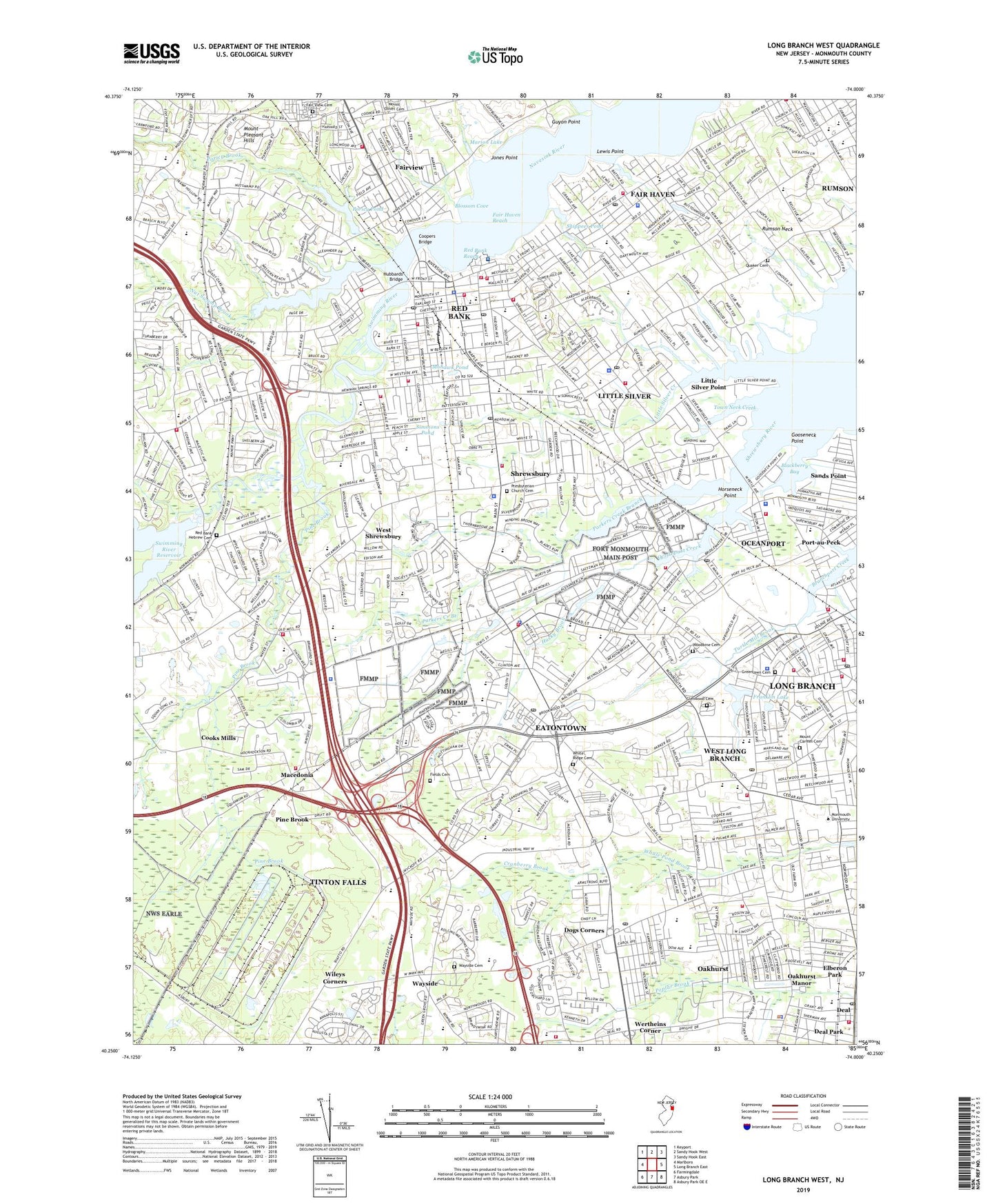
2019 topographic map quadrangle Long Branch West in the state of New Jersey. Scale: 1:24000. Based on the newly updated USGS 7.5' US Topo map series, this map is in the following counties: Monmouth. The map contains contour data, water features, and other items you are used to seeing on USGS maps, but also has updated roads and other features. This is the next generation of topographic maps. Printed on high-quality waterproof paper with UV fade-resistant inks.
Quads adjacent to this one:
West: Marlboro
Northwest: Keyport
North: Sandy Hook West
Northeast: Sandy Hook East
East: Long Branch East
Southeast: Asbury Park OE E
South: Asbury Park
Southwest: Farmingdale
Contains the following named places: 185 Monmouth Parkway Associates Helistop, Alexanders-Eatontown, ARC Dorothy B Hersh High School, Betty McElmon Elementary School, Blackberry Bay, Blackberry Bay Park, Blossom Cove, Bodman Park, Borough of Eatontown, Borough of Fair Haven, Borough of Little Silver, Borough of Oceanport, Borough of Red Bank, Borough of Rumson, Borough of Shrewsbury, Borough of Tinton Falls, Borough of West Long Branch, Branchport Park, Branchport Station, Broadway Post Office, Camp Charles Wood, Camp Coles, Center Play School, Charles Wood Helipad, Cooks Mills, Coopers Bridge, Cranberry Brook, Creative Learning Center School, Deal Fire Company 2, Deal Park, Deal Post Office, Deal Yeshiva School, Deane Porter Elementary School, Deans Nursery, Dogs Corners, Due Process Stables Heliport, E A I Landing Strip, Eatontown, Eatontown Circle, Eatontown Dam, Eatontown Fire Department, Eatontown Industrial Park, Eatontown Post Office, Elberon Park, Fair Haven, Fair Haven Post Office, Fair Haven Reach, Fair Haven Volunteer Fire Company, Fair View Cemetery, Fairview, Fairview Census Designated Place, Fairview Elementary School, Fields Cemetery, Forrestdale Middle School, Fort Monmouth, Fort Monmouth Golf Club, Fourth Creek, Frank Antonides Elementary School, Franklin Lake, Franklin Lake Dam, Glenwood Cemetery, Goddard School, Gooseneck Point, Greely Helipad, Greenlawn Cemetery, Guyon Point, Harbor School, Highland Manor School, Highlands Seaplane Base, Hillel High School, Hillel Yeshiva School, Hockhockson Brook, Hollywood Golf Course, Horseneck Point, Hubbards Bridge, Husky Brook, Joe Palaia Park, John Parker Park, Jones Point, Kinder College Early Childhood Preschool, Kiva High School, Knollwood Elementary School, Lewis Point, Lincroft, Lincroft Park, Little Silver, Little Silver Creek, Little Silver Point, Little Silver Post Office, Little Silver Volunteer Fire Company 1, Long Branch Board of Education, Macedonia, Mahala F Atchinson Elementary School, Manson Park, Maple Place Elementary School, Margaret L Vetter Elementary School, Marine Park, Marion Lake, Markham Place Elementary School, McClees Creek, Meadowbrook Elementary School, Memorial Elementary School, Mid - Monmouth Industrial Park, Middletown High School South, Mohawk Pond, Monmouth Adult Education Community School, Monmouth Mall Shopping Center, Monmouth Race Track, Monmouth Regional High School, Monmouth University, Monmouth Water Works, Mosquito Commission Headquarters Heliport, Mount Carmel Cemetery, Navesink Country Club, Normandy Park, Norwood Country Club, Nut Swamp Brook, Nut Swamp Elementary School, Oakhurst, Oakhurst Census Designated Place, Oakhurst Country Day School, Oakhurst Manor, Oakhurst Post Office, Oakhurst School, Oakwood School, Ocean Township Elementary School, Ocean Township High School, Ocean Township Intermediate School, Oceanport, Oceanport Creek, Oceanport Hook and Ladder Volunteer Fire Company, Oceanport Post Office, Old Orchard Country Club, Parkers Creek, Parkers Creek Branch, Pine Brook, Pine Brook School, Point Road Elementary School, Poricy Brook, Poricy Dam, Poricy Park, Poricy Pond, Port-au-Peck, Presbyterian Church Cemetery, Quaker Cemetery, Ranney School, Red Bank, Red Bank Airport, Red Bank Catholic High School, Red Bank Charter School, Red Bank Fire Department Fire Marshal, Red Bank Hebrew Cemetery, Red Bank Middle School, Red Bank Post Office, Red Bank Primary School, Red Bank Reach, Red Bank Regional High School, Regional Alternative School, River Plaza, River Plaza Elementary School, River Street School, Riverview Medical Center, Rumson Country Club, Rumson Country Day School, Rumson Fair Haven Regional High School, Rumson Neck, Saint James Elementary School, Saint Jerome Elementary School, Saint Leo the Great Roman Catholic School, Saint Leo the Great School, Sands Point, School for Children, Shadow Lake, Shadow Lake Dam, Shippees Pond, Shore Acres Estate, Shore Regional High School, Shrewsbury, Shrewsbury Elementary School, Shrewsbury Fire Marshal's Officel, Shrewsbury Plaza Shopping Center, Shrewsbury Post Office, Simmons Pond, Steelman School, Stevenson Park, Swimming River, Swimming River Country Club, Swimming River Elementary School, Swimming River Natural Area, Swimming River Reservoir Dam, The Grove Shopping Center, Thompson Middle School, Tinton Falls, Tinton Falls Middle School, Tower Hill School, Town Neck Creek, Township of Ocean, Township of Ocean Fire Prevention Bureau, Township of Shrewsbury, Turtle Mill Brook, Vincent S Mastro Montessori Academy School, Viola L Sickles Elementary School, Wampum Brook, Wayside, Wayside Cemetery, Wayside Elementary School, Weltz Park, Wertheins Corner, West Long Branch, West Long Branch Post Office, West Shrewsbury, West Side Christian Academy, Westboro Post Office, White Ridge Cemetery, WHTG-AM (Eatontown), WHTG-FM (Eatontown), Wileys Corners, Winding Brook School, WMCX-FM (West Long Branch), Wolf Hill Elementary School, Wolf Hill Recreation Area, Wolf Hills Farm, Woodbine Cemetery and Mausoleum, Woodmere Elementary School, WRTV Radio Tower (Conway), ZIP Codes: 07701, 07702, 07703, 07704, 07724, 07739, 07755, 07757, 07760, 07764