MyTopo
Moorestown New Jersey US Topo Map
Couldn't load pickup availability
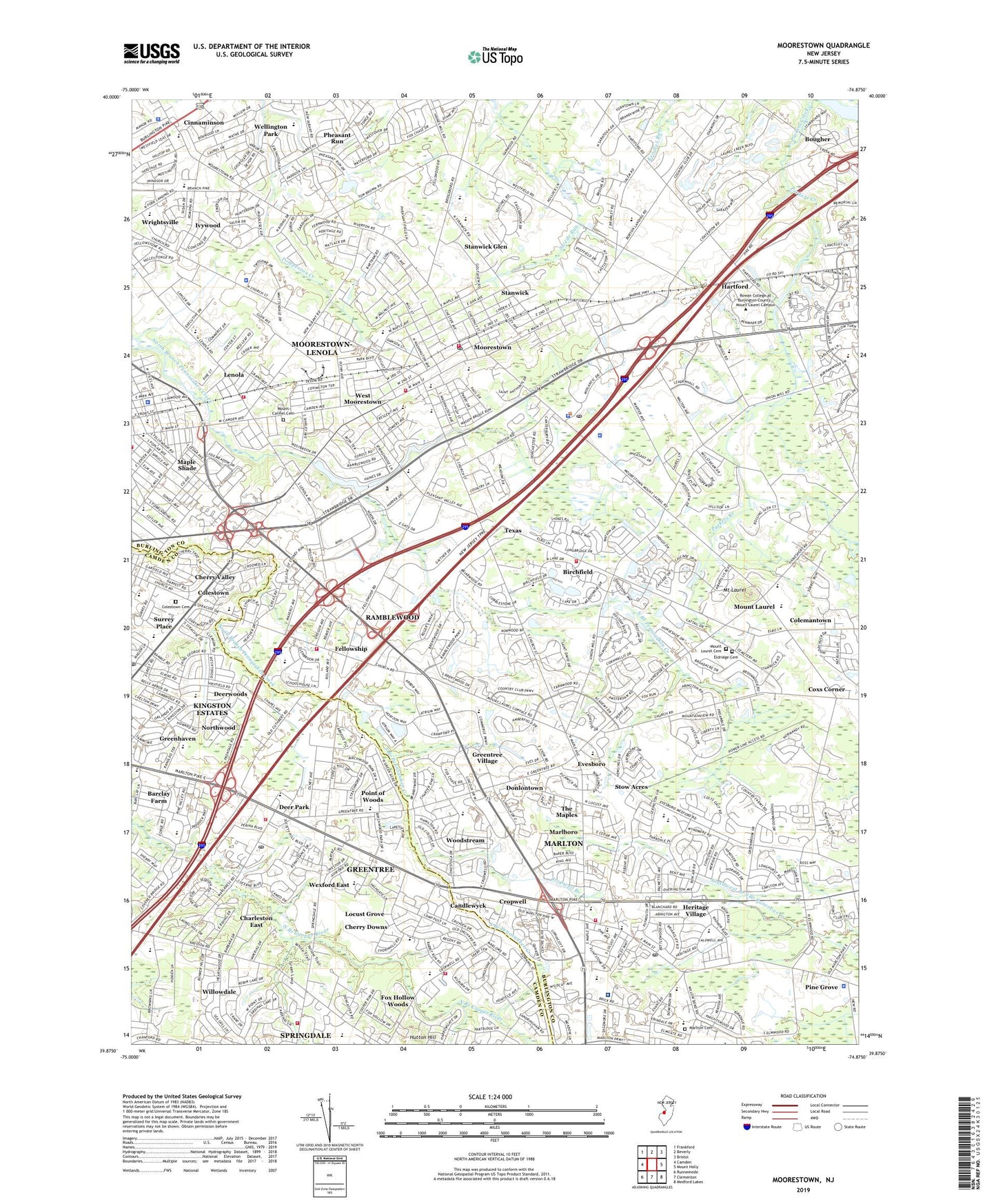
2019 topographic map quadrangle Moorestown in the state of New Jersey. Scale: 1:24000. Based on the newly updated USGS 7.5' US Topo map series, this map is in the following counties: Burlington, Camden. The map contains contour data, water features, and other items you are used to seeing on USGS maps, but also has updated roads and other features. This is the next generation of topographic maps. Printed on high-quality waterproof paper with UV fade-resistant inks.
Quads adjacent to this one:
West: Camden
Northwest: Frankford
North: Beverly
Northeast: Bristol
East: Mount Holly
Southeast: Medford Lakes
South: Clementon
Southwest: Runnemede
Contains the following named places: A M Rodgers Construction Company, Bancshares Helistop, Baptist Regional Elementary School, Barclay Farm, Barclay School, Barclay Towers, Barclay-Kingston Census Designated Place, Beeler Elementary School, Bethel Church, Birchfield, Bougher, Brainerd School, Britt School, Burlington County College - Mount Laurel, Cambridge, Camden Community College Rohrer City, Candlewyck, Caputo Helistop, Charleston East, Chemical Bank-New Jersey National Heliport, Cherry Downs, Cherry Hill Alternative High School, Cherry Hill Fire Department Station 3, Cherry Hill Fire Department Station 4, Cherry Hill High School East, Cherry Hill Post Office, Cherry Valley, Chesterville, Cinnaminson, Cinnaminson Fire Department Headquarters, Cinnaminson Middle School, Cinnaminson Police Department, Cistercian Monastery, Colemantown, Colestown, Colestown Cemetery, Collins Field, Countryside Elementary School, Coxs Corner, Cropwell, Cropwell Branch, Deer Park, Deer Park Fire Company, Deerwoods, Donlontown, Eldridge Cemetery, Ellisburg Post Office, Estelle Malberg Alternative School, Evans Corner, Evergreen Home for the Aged, Evesboro, Evesham Fire and Rescue, Evesham Township Fire Administration, Evesham Township Police Department, Excel Learning Center School, Fellowship, Florence V Evans Elementary School, Fox Hollow Woods, Frances Demasi Elementary School, Frances Demasi Middle School, George C Baker Elementary School, Greenberg Center for Education School, Greenhaven, Greentree, Greentree Census Designated Place, Greentree Village, Griffin Associates Heliport, Haig Elementary School, Harold Van Zant Elementary School, Hartford, Henry C Beck Middle School, Heritage Christian Academy School, Heritage Junior High School, Heritage Village, Hillman Church, Hillside Elementary School, Hooten Creek, Immaculate Conception Novitiate, Ivywood, J F Cooper Elementary School, J Harold Van Zant Elementary School, Jacobs Chapel, James F Cooper Elementary School, John A Carusi Middle School, Joseph D Sharp Elementary School, Joyful Noise Christian Preschool, Just Children Preschool, Katz Jewish Community Center Preschool, Kindercare Learning Center School, Kings Christian High School, Kingston Elementary School, Kingston Estates, Kingston Estates Census Designated Place, Kingsway Learning Center School, Larchmont Elementary School, Lenola, Lenola Fire Company / Lenola Fire Company Emergency Unit, Lockheed Martin Emergency Medical Services, Locust Grove, Maple Shade, Maple Shade Fire Department, Maple Shade Police Department, Marlboro, Marlton, Marlton Cemetery, Marlton Census Designated Place, Marlton Christian Academy School, Marlton Post Office, Marlton Rehabilitation Hospital, Mary E Roberts Elementary School, Maude M Wilkins Elementary School, Montessori Childrens House School, Montessori Learning Center School, Moorestown, Moorestown Fire District 1 Relief Engine Company, Moorestown First Aid and Emergency Squad, Moorestown Friends School, Moorestown High School, Moorestown Hose Company Number 1 Fire Station, Moorestown Police Department, Moorestown Post Office, Moorestown Upper Elementary School, Moorestown-Lenola Census Designated Place, Mount Carmel Cemetery, Mount Laurel, Mount Laurel Cemetery, Mount Laurel Fire Department Headquarters and Administration, Mount Laurel Fire Department Station 362, Mount Laurel Fire Department Station 363, Mount Laurel Post Office, Mount Laurel State Park, Mount Laurel Township Emergency Medical Services Station 368, Mount Laurel Township Police Department, New Albany Elementary School, New Jersey State Police Troop D Moorestown Station, New Jersey Turnpike Authority Heliport, Northwood, Our Lady of Good Counsel School, Our Lady of Perpetual Help School, Paragon Country Club, Parkway Elementary School, Pheasant Run, Phillips School, Pine Grove, Pleasant Valley Nursery School, Point of Woods, Ralph J Steinhauer Elementary School, Ramblewood, Ramblewood Census Designated Place, Ramblewood Country Club, Richard Stockton Elementary School, Robert B Jaggard Elementary School, Rosa International Middle School, Saint Charles Borromeo School, Saint Joan of Arc Elementary School, Saint Marys Church, Saint Marys Home for the Aged, Saint Matthews Church, Saint Michaels Church, Saint Peter Celestine Catholic School, South Valley Elementary School, Spring Hill Country Club, Springdale, Springdale Census Designated Place, Stanwick, Stanwick Glen, Stanwick School, Stow Acres, Strabel School, Strawbridge Lake, Strawbridge Lake Upper Dam, Surrey Place, Temple Beth Sholom Preschool, Temple Emanuel Preschool, Texas, The Goddard School - Cherry Hill, The Goddard School - Mount Laurel, The Kings Christian School, The Maples, Thomas E Harrington Middle School, Thomas Paine Elementary School, Township of Cherry Hill, Township of Maple Shade, Township of Moorestown, Township of Mount Laurel, Trinity Church, Under The Sun Learning Center School, Virtua Health System Emergency Medical Services Headquarters, Virtua Health System Emergency Medical Services Medic 35, Virtua Marlton Hospital, Weisman Childrens Rehabilitation Hospital, Wellington Park, West Moorestown, Westfield Friends School, Wexford East, Wiley Mission, William Allen III Middle School, Willowdale, Wilsons Station, Wood Park, Woodstream, Wrightsville, ZIP Codes: 08003, 08052, 08054, 08057