MyTopo
Beverly New Jersey US Topo Map
Couldn't load pickup availability
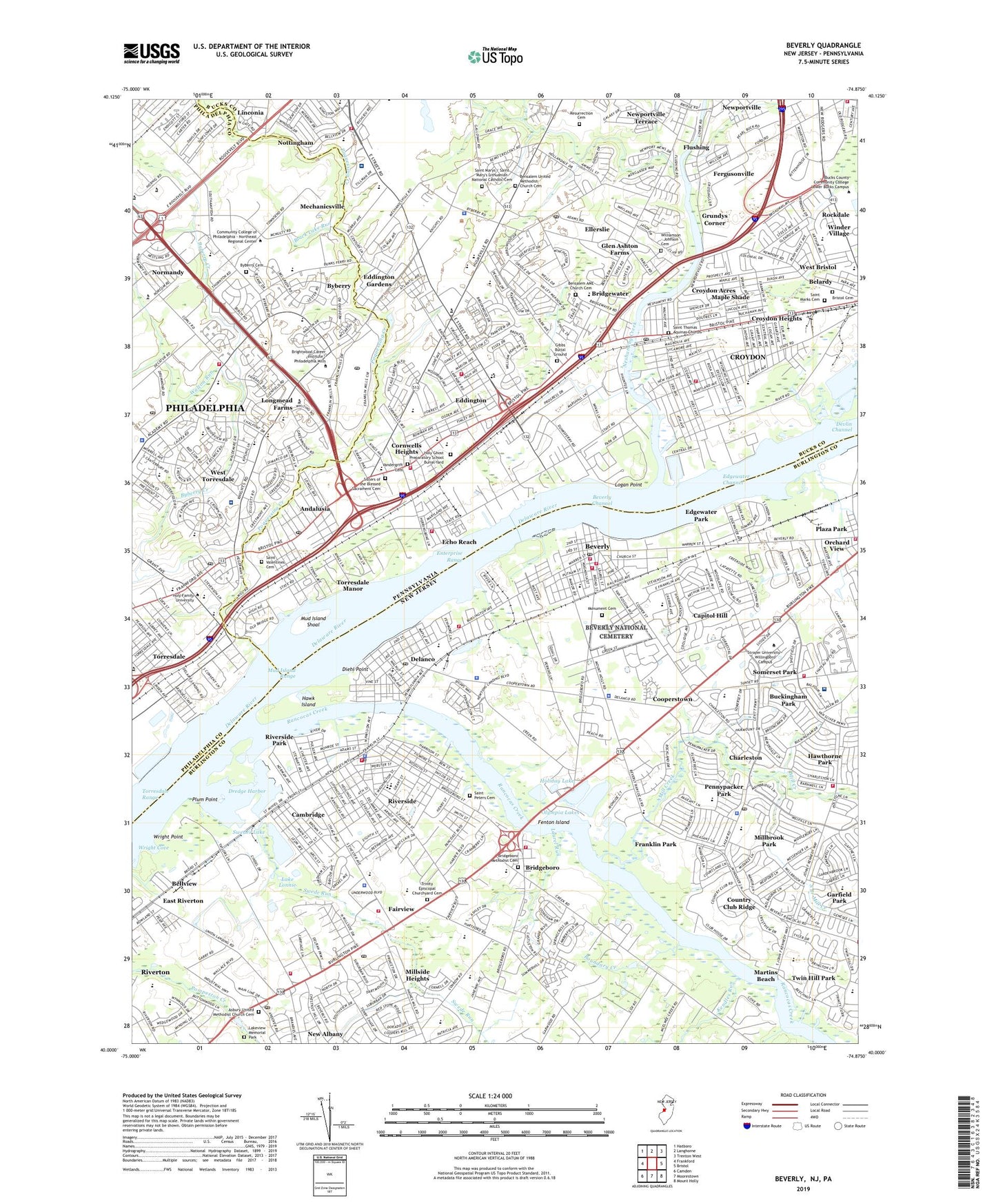
2023 topographic map quadrangle Beverly in the states of Pennsylvania, New Jersey. Scale: 1:24000. Based on the newly updated USGS 7.5' US Topo map series, this map is in the following counties: Burlington, Bucks, Philadelphia. The map contains contour data, water features, and other items you are used to seeing on USGS maps, but also has updated roads and other features. This is the next generation of topographic maps. Printed on high-quality waterproof paper with UV fade-resistant inks.
Quads adjacent to this one:
West: Frankford
Northwest: Hatboro
North: Langhorne
Northeast: Trenton West
East: Bristol
Southeast: Mount Holly
South: Moorestown
Southwest: Camden
Contains the following named places: Academy Garden, Andalusia, Asbury United Methodist Church Cemetery, Baxter Water Treatment Plant, Belardy, Bellview, Benjamin Rush State Park, Bensalem, Bensalem African Methodist Episcopal Church Cemetery, Bensalem Country Club, Bensalem Plaza, Bensalem Plaza Shopping Center, Bensalem Shopping Center, Bensalem Square Shopping Center, Bensalem United Methodist Church Cemetery, Bensalem Village, Berkeley Trace, Beverly, Beverly Channel, Beverly National Cemetery, Black Lake Run, Borton Landing, Boundary Creek, Bridgeboro, Bridgewater, Bridgewater Industrial Park, Bristol Cemetery, Broadwood Shopping Center, Brookwood, Buckingham Park, Byberry, Byberry Creek, Byberry Friends Burial Ground, Cambridge, Capitol Hill, Carriage Stop, Centre Plaza, Centre Plaza Shopping Center, Chalfont Playground, Charleston, Chestnut Wood Village, City of Beverly, Cooperstown, Copter-Liberty Bell Airport, Cornwell, Cornwells Golf Course, Cornwells Heights, Cornwells Heights Census Designated Place, Cornwells Heights Station, Cornwells Heights-Eddington Census Designated Place, Cornwells Industrial Park, Cornwells Manor, Country Club Ridge, Country Village at Center Point, County Downe Park Terrace, Crafton Plaza Shopping Center, Crestmont Farms, Croydon, Croydon Acres, Croydon Census Designated Place, Croydon Heights, Croydon Industrial Park, Croydon Mannor, Croydon Station, Delaire Landing, Delanco, Delaware Expressway Industrial Park, Delaware River Access Area, Devon Close, Devonshire, Diehl Point, Doral, Dredge Harbor, East Riverton, Echo Beach, Echo Reach, Eddington, Eddington Census Designated Place, Eddington Gardens, Eddington Park, Edgely Industrial Park, Edgewater Channel, Edgewater Park, Ellerslie, Enterprise Range, Fairview, Fenton Island, Fergusonville, Fitzpatrick Playground, Fluehr Park, Flushing, Franklin Mills, Franklin Mills Mall, Franklin Park, Garfield Park, Gibbs Burial Ground, Glen Ashton Farms, Glen Foerd, Grundys Corner, Handpointers, Hawk Island, Holiday Lake, Holy Ghost Preparatory School Burial Yard, I-95 Industrial Park, Jefferson Ward Shopping Center, Junod Playground, Kearney, Kendles Run, Kennedy Shopping Center, Keystone Estates, Keystone Industrial Park, Keystone Race Track, Knights Road Industrial Park, Lactona Corporation Airport, Lafayette Village, Lake Lonnie, Lake Louis, Lakeview Memorial Park, Laurel Run, Liberty Bell Industrial Park, Liberty Bell Park, Liberty Bell Racetrack, Logan Point, Longmead Farms, MacMillan Helistop, Makefield Terrace, Maple Shade, Marten Square, Marten Square Shopping Center, Martins Beach, Mechanicsville, Milbrook, Mill Creek, Millbrook Park, Millside Heights, Mitchell Playground, Modena Park, Monument Cemetery, Morrell Park, Mud Island Range, Mud Island Shoal, Neshaminy Creek, Neshaminy Green, Neshaminy Plaza, Neshaminy State Park, New Albany, Newport Mews, Newportville, Newportville Terrace, Normandy, Nottingham, Olympia Lakes, Palmer Playground, Parkers Creek, Parkwood Manor, Pennypacker Park, Philadelphia Industrial Park, Picariello Playground, Plaza Park, Pleasanthill Park, Plum Point, Poquessing Creek, Rancocas Creek, Rancocas Hospital Heliport, Red Lion, Resurrection Cemetery, Richlieu Gardens, Richlieu Industrial Park, Riverside, Riverside Park, Riverton, Riverton Cove, Riverview Industrial Park, Rockdale, Ronson-Delanco Helistop, Saint Marks Cemetery, Saint Mary's Lithuanian National Catholic Cemetery, Saint Peters Cemetery, Saint Thomas Aquinas Churchyard, Saint Valentines Cemetery, Sharper, Shedaker Station, Show Case Plaza Shopping Center, Showcase Plaza, Sisters of the Blessed Sacrament Cemetery, Skin Corner, Somerset Park, Sons Heliport, South Branch Mill Creek, Stanwood, State Road Industrial Park, Street Road Shopping Center, Swede Run, Swedes Lake, Terrys Trailer Park, The Coves of Hidden Valley, Topridge Trailer Park, Torresdale Manor, Torresdale Playground, Torresdale Range, Torresdale-Frankford Country Club, Township of Bensalem, Township of Cinnaminson, Township of Delanco, Township of Delran, Township of Edgewater Park, Township of Riverside, Township of Willingboro, Trinity Episcopal Churchyard Cemetery, Twin Hill Park, Union Landing, Valley Meadows, Vandergrift Cemetery, Vine Street Park, Walton Run, Walton Run Park, Wes-Port Equipment Park Airport, West Bristol, West Torresdale, Williamson - Johnson Cemetery, Willingboro Plaza, Willingboro Town Center Shopping Center, Woodhaven Industrial Park, Woodhaven Mall, Woodhaven Mall Shopping Center, Woodridge East, Wright Cove, Wright Point, ZIP Codes: 08010, 08046, 08075, 08077, 19020, 19021, 19154