MyTopo
Pitman East New Jersey US Topo Map
Couldn't load pickup availability
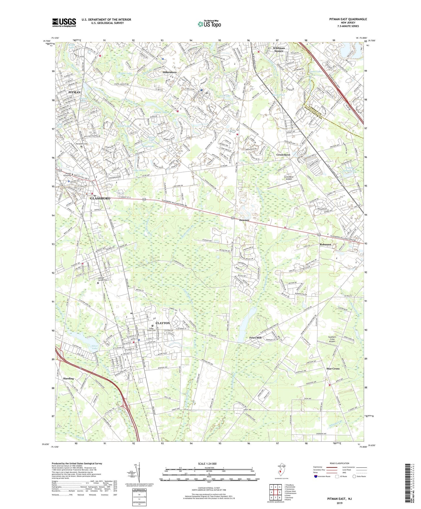
2019 topographic map quadrangle Pitman East in the state of New Jersey. Scale: 1:24000. Based on the newly updated USGS 7.5' US Topo map series, this map is in the following counties: Gloucester, Camden. The map contains contour data, water features, and other items you are used to seeing on USGS maps, but also has updated roads and other features. This is the next generation of topographic maps. Printed on high-quality waterproof paper with UV fade-resistant inks.
Quads adjacent to this one:
West: Pitman West
Northwest: Woodbury
North: Runnemede
Northeast: Clementon
East: Williamstown
Southeast: Buena
South: Newfield
Southwest: Elmer
Contains the following named places: Ann A Mullen Middle School, Archway School - Washington Township, Baum Pond, Beacon Academy Preschool and Kindergarten, Beaverdam Branch, Birches Elementary School, Borough of Clayton, Borough of Glassboro, Bunker Hill Church, Bunker Hill Middle School, Bunker Hill School, Cedar Green Cemetery, Cedar Lake, Chapel Heights Church, Chesterbrook Academy Preschool, Church of the Shepherd, Clayton, Clayton High School, Clayton Middle School, Clayton Office Fire Prevention, Clayton Police Department, Clayton Post Office, Clayton Volunteer Fire Company 1, College Town Shopping Center, Cross Keys, Cross Keys Airport, Crystal Spring Lake, Crystal Spring Lake Dam, Dilkesboro, Dorothy L Bullock School, Downer, Downer Airstrip, Duffield Run, Ebenezer Church, Elwood Kindle Elementary School, Faith Christian Academy School, Fries Mill, Fries Mill Dam, Glassboro, Glassboro Fire Department, Glassboro Fish and Wildlife Management Area, Glassboro High School, Glassboro Intermediate School, Glassboro Police Department, Glassboro Post Office, Gloucester County Emergency Medical Services Station 82 - 8, Gloucester County Emergency Medical Services Station 82 - 9, Gloucester County Fire Marshal's Office, Harding, Herma S Simmons Elementary School, Holly Glen Elementary School, Hollydell School, Hurffville Fire Company - Substation, Irvin Lake, Janvier, Jones Lake, Kandle Lake, Kennedy University Hospital - Washington Township, Kressey Lake, Lake Oberst, Land Of Canaan Cemetery, Lawns Volunteer Fire Company, Manahath Cemetery, Maryville Church, Maryville Treatment Center, Mount Zion Church, Muth Family Farm, New World Temple, Olivet Pilgrim Church, Orchard Valley Middle School, Reeder Airport, Robanna, Robert Schober Orchards, Rowan University, Rowan University Emergency Medical Services, Saint Bridget Regional School, Saint Catherine of Siena Regional School, Saint Catherines Church, Saint Johns Church, Saint Judes Regional School South Annex, Saint Matthews Church, Saint Pauls Church, Senior Lakes, Silver Lake, Silver Lake Dam, Slab Bridge Branch, Southern Cross Airport, Spring Lake, Star Cross, Star Cross Volunteer Fire Company, The Goddard School - Sicklerville, Thomas Jefferson Elementary School, TLC Nursery School and Learning Center, Township of Washington, Turnersville Post Office, Ward Lake, Washington Township Ambulance and Rescue, Washington Township Fire Department - Whitman Square Substation, Washington Township Fire Department Station 10 - 3 Hurffville Fire Company, Washington Township Fire District Headquarters, Washington Township High School, Washington Twp Police Dept, WGLS-FM (Glassboro), Whitman Elementary School, Whitman Square, Whitman Square Fire Company - Substation, Williamstown Fire Company Substation, Williamstown High School, Williamstown Middle School, Wilson Lake, ZIP Codes: 08028, 08312