MyTopo
Pitman West New Jersey US Topo Map
Couldn't load pickup availability
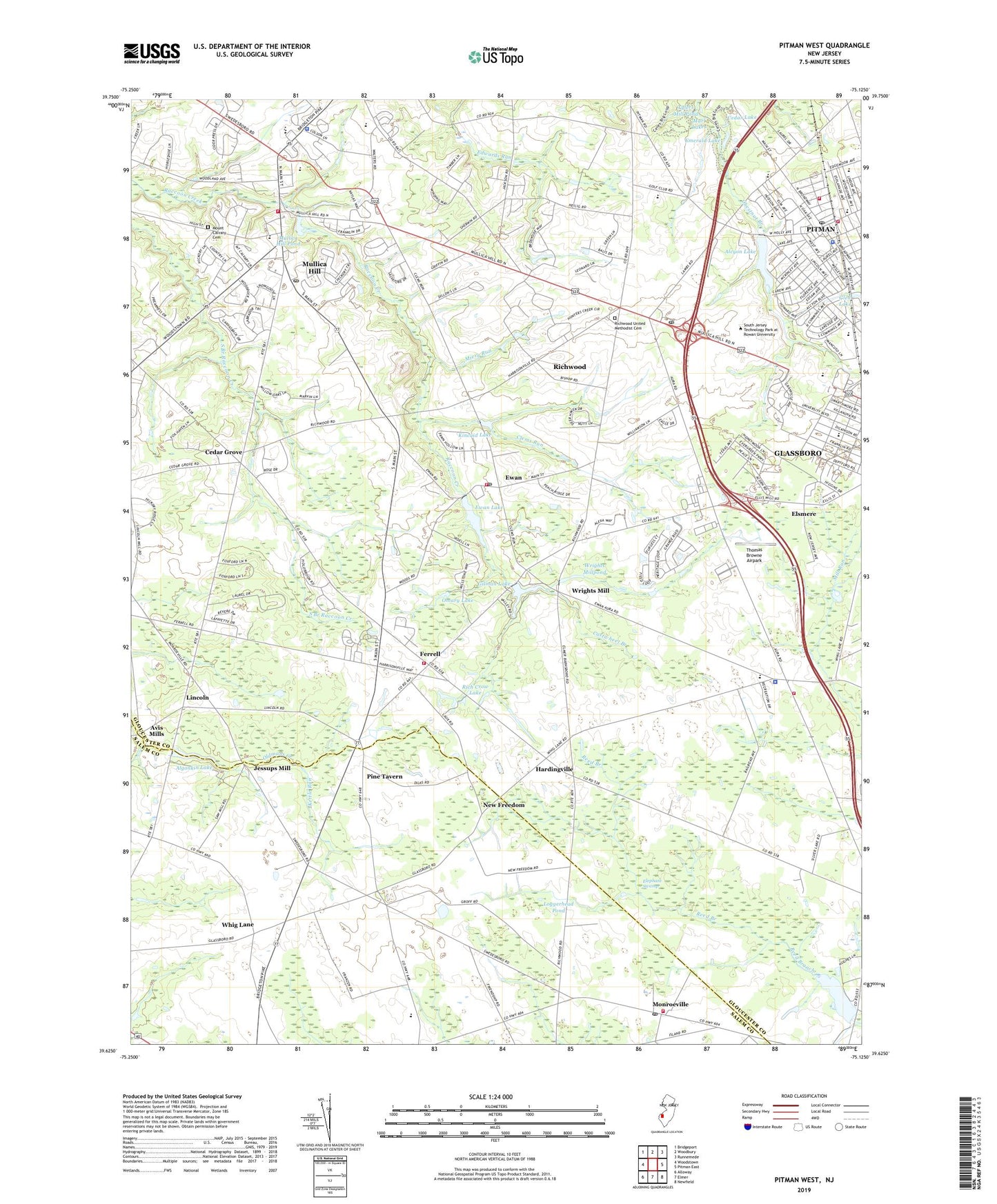
2023 topographic map quadrangle Pitman West in the state of New Jersey. Scale: 1:24000. Based on the newly updated USGS 7.5' US Topo map series, this map is in the following counties: Gloucester, Salem. The map contains contour data, water features, and other items you are used to seeing on USGS maps, but also has updated roads and other features. This is the next generation of topographic maps. Printed on high-quality waterproof paper with UV fade-resistant inks.
Quads adjacent to this one:
West: Woodstown
Northwest: Bridgeport
North: Woodbury
Northeast: Runnemede
East: Pitman East
Southeast: Newfield
South: Elmer
Southwest: Alloway
This map covers the same area as the classic USGS quad with code o39075f2.
Contains the following named places: Alcyon Lake, Alcyon Lake Dam, Alcyon Park, Algonkin Lake, Ambassador Christian Academy School, Aura, Aura Elementary School, Aura Volunteer Fire Company No 1, Avis Mills, Barnsboro Church, Betty Park, Borough of Pitman, Cartwheel Branch, Cedar Grove, Cedar Lake, Clems Run, Elephant Swamp, Elk Township Police Dept, Elsmere, Elsmere School, Emanuel Church, Emerald Lake, Ewan, Ewan Lake, Ewan Post Office, Ewan Volunteer Fire Company, Ewans Mill Dam, Faith Church, Ferrell, Ferrell Volunteer Fire Company and Rescue, Franzens Strip, Friends School - Mullica Hill, Fruitwood Farms, Garrison Lake, Gilman Lake, Glen Lake, Gloucester County, Gloucester County Christian School, Hardingville, HARMONY EMS, Harmony Volunteer Fire Department, Harrison Township Elementary School, Harrison Twp Police Dept, Holiness Camp, Holy Name Church, J Harvey Rodgers School, Jessups Mill, Kettle Run, Kincaid Lake, Kincaid Lake Dam, Kraemer Heliport, Laytons Airfield, Lincoln, Loggerhead Pond, Marl Lakes, Memorial Elementary School, Miery Run, Monroeville, Monroeville Post Office, Monroeville Volunteer Fire Company, Mount Calvary Cemetery, Mount Calvary Church, Mount Moriah Church, Mount Pleasant Orchards, Mullica Hill, Mullica Hill Census Designated Place, Mullica Hill Pond, Mullica Hill Post Office, Neale's Orchards, New Freedom, Omary Lake, Pine Tavern, Pitman, Pitman Country Club, Pitman Emergency Medicdal Services, Pitman Fire Department Station 28 - 1 Pitman Fire Company, Pitman Fire Department Station 28 - 2 Fire Patrol, Pitman Fire Department Station 28 - 3 Highland Chemical and Engine Company, Pitman High School, Pitman Middle School, Pitman Police Dept, Pitman Post Office, Plank Run, Pleasant Valley Elementary School, Rich Crow Lake, Richwood, Richwood Census Designated Place, Richwood Post Office, Richwood United Methodist Cemetery, Rough Acres Dam, Rough Acres Pond, Saint Cyprian Church, Siloam Church, Sony Music Heliport, Summit Avenue School, Thomas Browne Airpark, Thomas E Bowe Elementary School, Township of Elk, Township of Harrison, Trinity Church, Tylers Mill Pond, Upper Pittsgrove Elementary School, W C K Walls Elementary School, Whig Lane, Wrights Mill, Wrights Mill Dam, Wrights Millpond, ZIP Codes: 08062, 08071, 08074, 08343