MyTopo
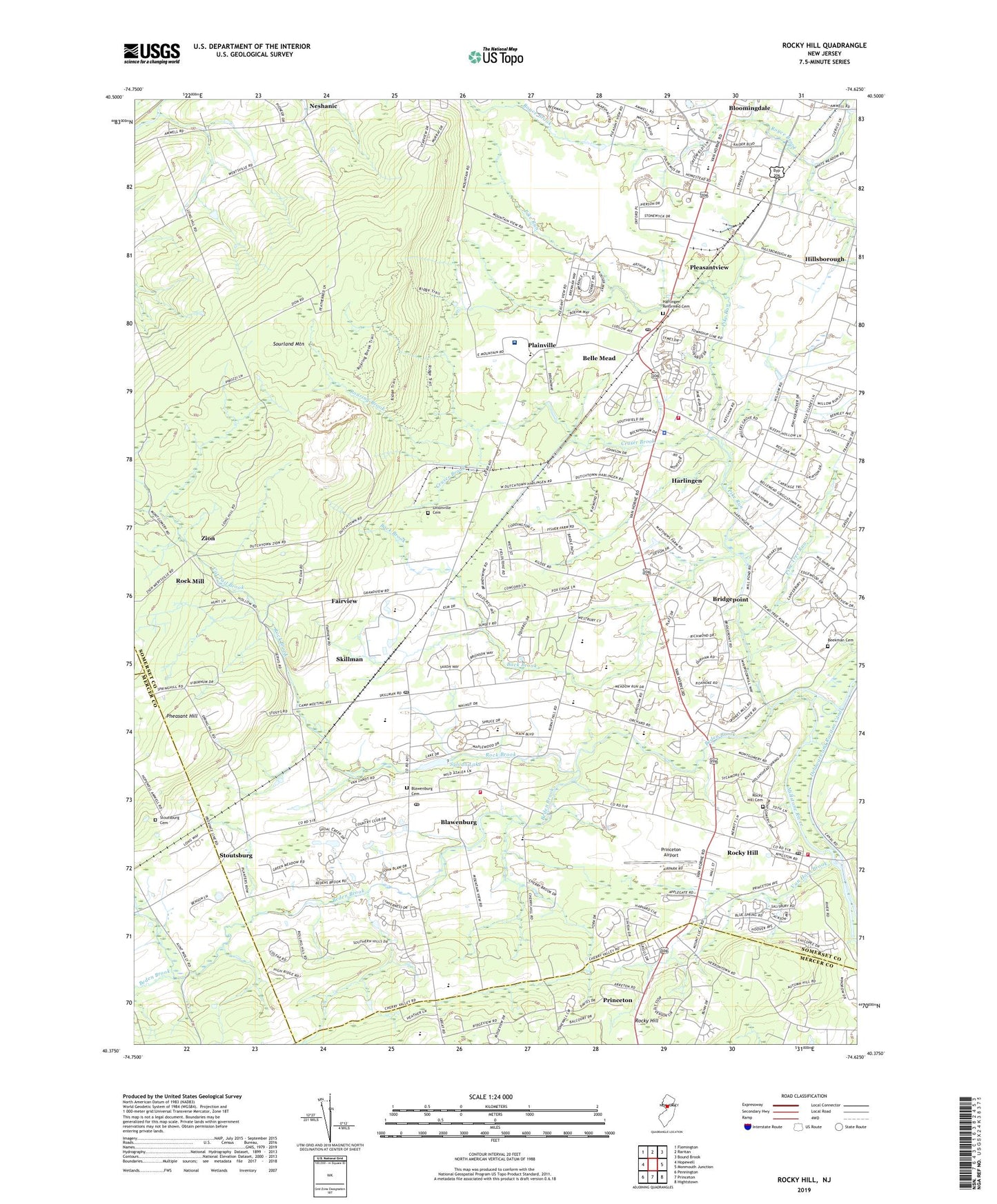
Rocky Hill New Jersey US Topo Map
Couldn't load pickup availability
2019 topographic map quadrangle Rocky Hill in the state of New Jersey. Scale: 1:24000. Based on the newly updated USGS 7.5' US Topo map series, this map is in the following counties: Somerset, Mercer, Hunterdon. The map contains contour data, water features, and other items you are used to seeing on USGS maps, but also has updated roads and other features. This is the next generation of topographic maps. Printed on high-quality waterproof paper with UV fade-resistant inks.
Quads adjacent to this one:
West: Hopewell
Northwest: Flemington
North: Raritan
Northeast: Bound Brook
East: Monmouth Junction
Southeast: Hightstown
South: Princeton
Southwest: Pennington
Contains the following named places: All Day Learning Centers School, Autumn Hill Park, Back Brook, Beden Brook, Bedens Brook Country Club, Beekman Cemetery, Belle Mead, Belle Mead Census Designated Place, Belle Mead General Depot, Belle Mead Post Office, Belle Mead Quarry, Belle Mead Station, Blawenburg, Blawenburg Cemetery, Blawenburg Census Designated Place, Blawenburg Post Office, Blawenburg Reformed Church, Bloomingdale, Borough of Rocky Hill, Bridgepoint, Bridgepoint Lake, Burnt Hill Road School, Camp Agnes DeWitt, Carrier Clinic, Carrier Clinic Behavioral Healthcare System, Cat Tail Brook, Childrens Workshop School, Cruser Brook, Dead Tree Run, Delaware and Raritan Canal, Delaware and Raritan State Park, Dutchtown, East Mountain Hospital, East Mountain School, Fairview, First Reformed Church, Fox Brook, Freedom Emergency Medical Services, Harlingen, Harlingen Census Designated Place, Harlingen Reformed Cemetery, Harlingen Reformed Church, Herrontown Woods Arboretum, Hillsborough, Hillsborough Church, Hillsborough High School, Hopewell Presbyterian Church, Johnson and Johnson Child Development Center School, Kiddie Academy School of Hillsborough, Kindercare Learning Center School, Kingdom Hall of Jehovahs Witnesses Church, Lloyd McCorkle Training School for Boys and Girls, Montgomery Emergency Medical Services, Montgomery Evangelical Church, Montgomery Kid Connection School, Montgomery Park, Montgomery Shopping Center, Montgomery Township High School, Montgomery Township Lower Middle School, Montgomery Township Police Department, Montgomery Township Volunteer Fire Company 2, Montgomery United Methodist Church, Montgomery Volunteer Fire Company 1, Montogomery Township Upper Middle School, Mount Zion Church, Neshanic, Neshanic Reformed Church, North Princeton Developmental Center, Orchard Hill Elementary School, Orchard Road Elementary School, Osterman Heliport, Our Lady of Princeton Convent, Pheasant Hill, Pike Run, Pine Brook Country Club, Pine Tree Run, Plainville, Pleasantview, Princeton Academy of the Sacred Heart School, Princeton Airport, Princeton House Behavioral Health, Princeton Montessori School, Princeton North Shopping Center, Roaring Brook, Rock Brook, Rock Brook School, Rock Mill, Rocky Hill, Rocky Hill Cemetery, Rocky Hill First Aid Rescue Squad, Rocky Hill Hook and Ladder Company 1, Rocky Hill Post Office, Route 518 Business Park, Saint Charles Borromeo Roman Catholic Church, Skillman, Skillman Census Designated Place, Skillman Dam, Skillman Post Office, Solid Rock Church, Sourland Mountain, Sourland Mountain County Preserve, Stoutsburg, Stoutsburg Cemetery, Sylvan Lake, Township of Hillsborough, Township of Montgomery, Trinity Church, Unionville Cemetery, Van Horn Brook, Village Elementary School, Waldorf School of Princeton, Zion, ZIP Codes: 08502, 08553, 08558, 08844