MyTopo
Flemington New Jersey US Topo Map
Couldn't load pickup availability
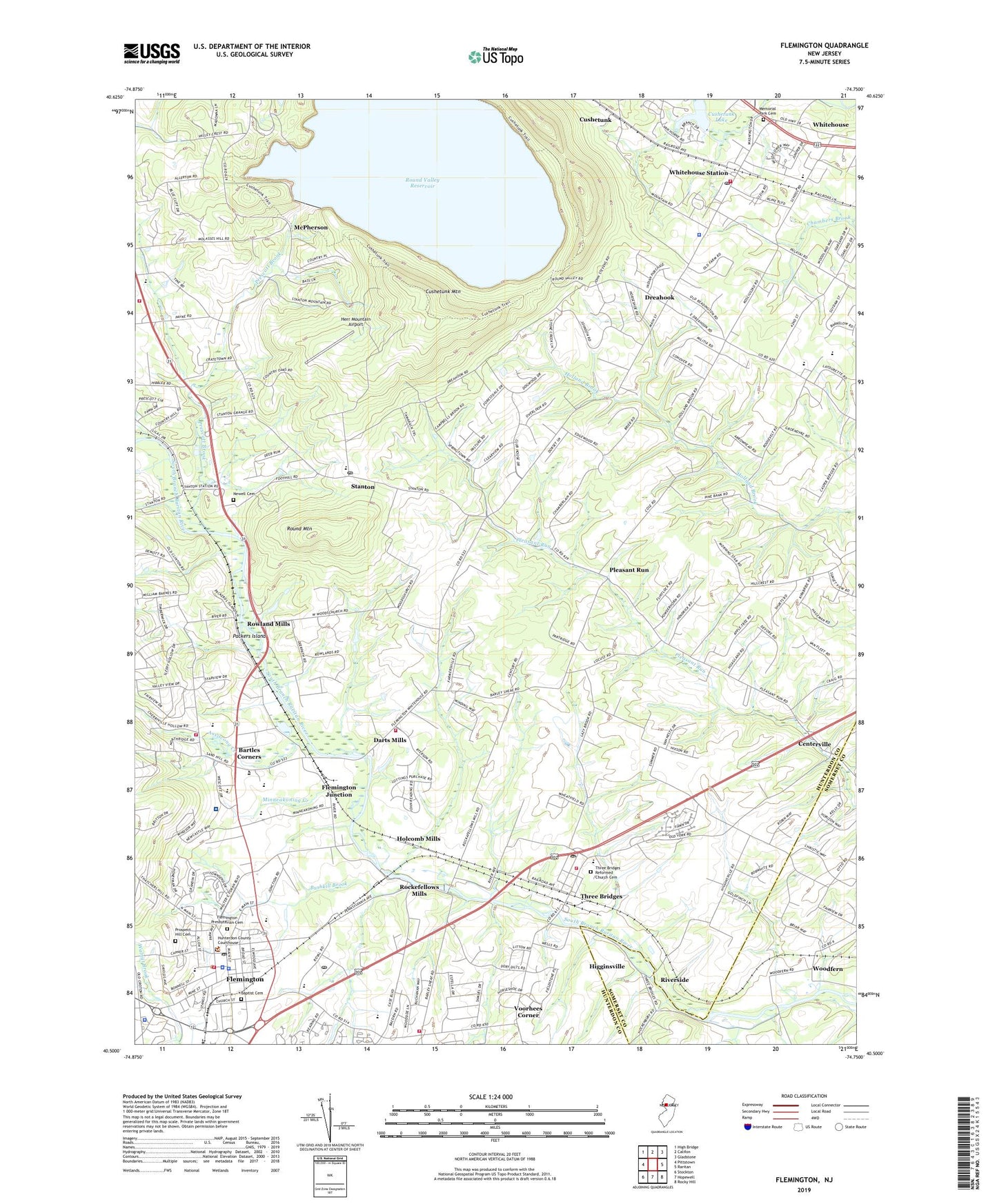
2023 topographic map quadrangle Flemington in the state of New Jersey. Scale: 1:24000. Based on the newly updated USGS 7.5' US Topo map series, this map is in the following counties: Hunterdon, Somerset. The map contains contour data, water features, and other items you are used to seeing on USGS maps, but also has updated roads and other features. This is the next generation of topographic maps. Printed on high-quality waterproof paper with UV fade-resistant inks.
Quads adjacent to this one:
West: Pittstown
Northwest: High Bridge
North: Califon
Northeast: Gladstone
East: Raritan
Southeast: Rocky Hill
South: Hopewell
Southwest: Stockton
This map covers the same area as the classic USGS quad with code o40074e7.
Contains the following named places: Acorn Montessori School, Annandale Hose Company 1 Station 2, Assiscong Creek, Baptist Cemetery, Barley Sheaf, Bartles Corners, Borough of Flemington, Bushkill Brook, Calvary Episcopal Church, Centerville, Century School, Cushetunk, Cushetunk Lake, Cushetunk Mountain, Darts Mills, Dreahook, Durling Farms, Echo Hill Camp, Flemington, Flemington - Raritan First Aid and Rescue Squad, Flemington Baptist Church, Flemington Borough Police Department, Flemington Circle, Flemington Country Day School, Flemington Fire Department, Flemington Free Public Library, Flemington Jewish Community Center, Flemington Junction, Flemington Post Office, Flemington Presbyterian Cemetery, Flemington Presbyterian Church, Flemington Speedway, Flemington United Methodist Church, Foran Foundry, Francis A Desmares Elementary School, Herr Mountain Airport, Higginsville, Holcomb Mills, Holland Brook Elementary School, Hunterdon Central High School, Hunterdon County Jail, Hunterdon County Polytech Academy School Bartles Corner Campus, Hunterdon County Polytech Academy School Central Campus, Hunterdon County Sheriff's Office, Hunterdon County Vocational High School, Hunterdon Medical Center, Hunterdon Medical Center Heliport, J P Case Middle School, Lance Airport, McPherson, Memorial Park Cemetery, Minneakoning Creek, Newell Cemetery, Oakgrove School, Packers Island, Pleasant Run, Prescott Brook, Prospect Hill Cemetery, Raritan Township Fire Company 21 Station 2, Raritan Township Fire Company 21 Station 3, Raritan Township Police Department, Reading Fleming Intermediate School, Readington Middle School, Readington Township Police Department, Red Rock Lake, Riverside, Rockefellows Mills, Rockefellows Mills Dam, Round Mountain, Round Valley Reservoir, Round Valley South Dam, Round Valley State Recreation Area, Rowland Mills, Saint Magdalen Church, Saint Paul Christian School, Spring Run School, Stanton, Stanton Learning Center School, Stanton Post Office, Stanton Reformed Church, Stanton Station, Three Bridges, Three Bridges Census Designated Place, Three Bridges Elementary School, Three Bridges Post Office, Three Bridges Reformed Church, Three Bridges Reformed Church Cemetery, Three Bridges School, Three Bridges Volunteer Fire Company, Three Bridges Volunteer Fire Company Substation, Township of Readington, Village Montessori School, Voorhees Corner, Voorhees Corner School, White House Station Census Designated Place, Whitehouse Elementary School, Whitehouse Rescue Squad, Whitehouse School, Whitehouse Station, Whitehouse Station Fire Company Station 22, Whitehouse Station Post Office, Woodfern, ZIP Codes: 08822, 08887, 08889