MyTopo
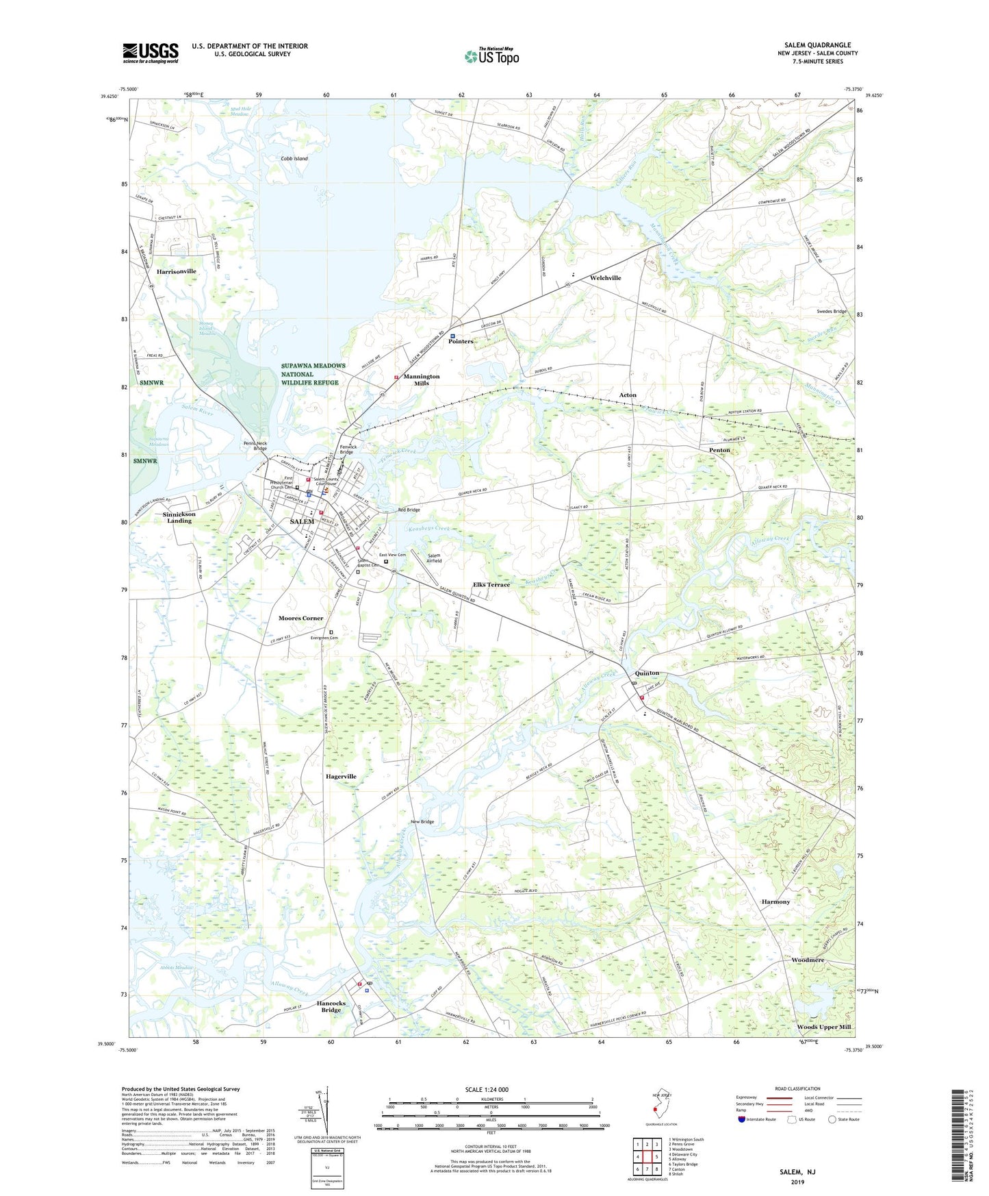
Salem New Jersey US Topo Map
Couldn't load pickup availability
2019 topographic map quadrangle Salem in the state of New Jersey. Scale: 1:24000. Based on the newly updated USGS 7.5' US Topo map series, this map is in the following counties: Salem. The map contains contour data, water features, and other items you are used to seeing on USGS maps, but also has updated roads and other features. This is the next generation of topographic maps. Printed on high-quality waterproof paper with UV fade-resistant inks.
Quads adjacent to this one:
West: Delaware City
Northwest: Wilmington South
North: Penns Grove
Northeast: Woodstown
East: Alloway
Southeast: Shiloh
South: Canton
Southwest: Taylors Bridge
Contains the following named places: Abbots Meadow, Acton, City of Salem, Clayville School, Cobb Island, Culliers Run, Deep Run, East View Cemetery, Elks Terrace, Elsinboro School, Elsinboro School Number 3, Evergreen Cemetery, Fenwick Bridge, Fenwick Community Ambulance, Fenwick Creek, First Presbyterian Church Cemetery, Hagerville, Halls Run, Hancocks Bridge, Hancocks Bridge Census Designated Place, Hancocks Bridge Post Office, Harmony, Harrisonville, John Fenwick Elementary School, Keasbeys Creek, Laurel Lake, Laurel Run, Liberty Fire Company 2, Lower Alloways Creek Emergency Medical Services and Rescue Squad, Lower Alloways Creek Fire and Rescue, Lower Alloways Creek Police Department, Majors Wharf, Mannington Creek, Mannington Elementary School, Mannington Meadow, Mannington Mills, Mannington Volunteer Fire Company Station 1, Market Street Historic District, Marlboro Marina, Memorial Hospital of Salem County, Moores Corner, Mud Hole Meadow, Muttontown Woods, New Bridge, New Cut, North Bend Hose Company, Paruszewski Farm Strip, Penns Neck Bridge, Penton, Pointers, Quinton, Quinton Ambulance Corporation, Quinton Census Designated Place, Quinton Fire Company, Quinton Post Office, Quinton Township Elementary School, Red Bridge, Salem, Salem Airfield, Salem Baptist Cemetery, Salem County Sheriff, Salem High School, Salem Middle School, Salem Police Department, Salem Post Office, Seabrook Heliport, Sinnickson Landing, Southern Training Center Heliport, Stoney Island Meadow, Swedes Bridge, Swedes Run, Town Hall School, Township of Elsinboro, Township of Mannington, Township of Quinton, Union Fire Company 1, Washington Fire Company 3, Welchville, WJIC-AM (Salem), Woodmere, Woodmere Dam, Woodmere Lake, Woods Upper Mill, Wyncoop School, ZIP Codes: 08072, 08079