MyTopo
Shiloh New Jersey US Topo Map
Couldn't load pickup availability
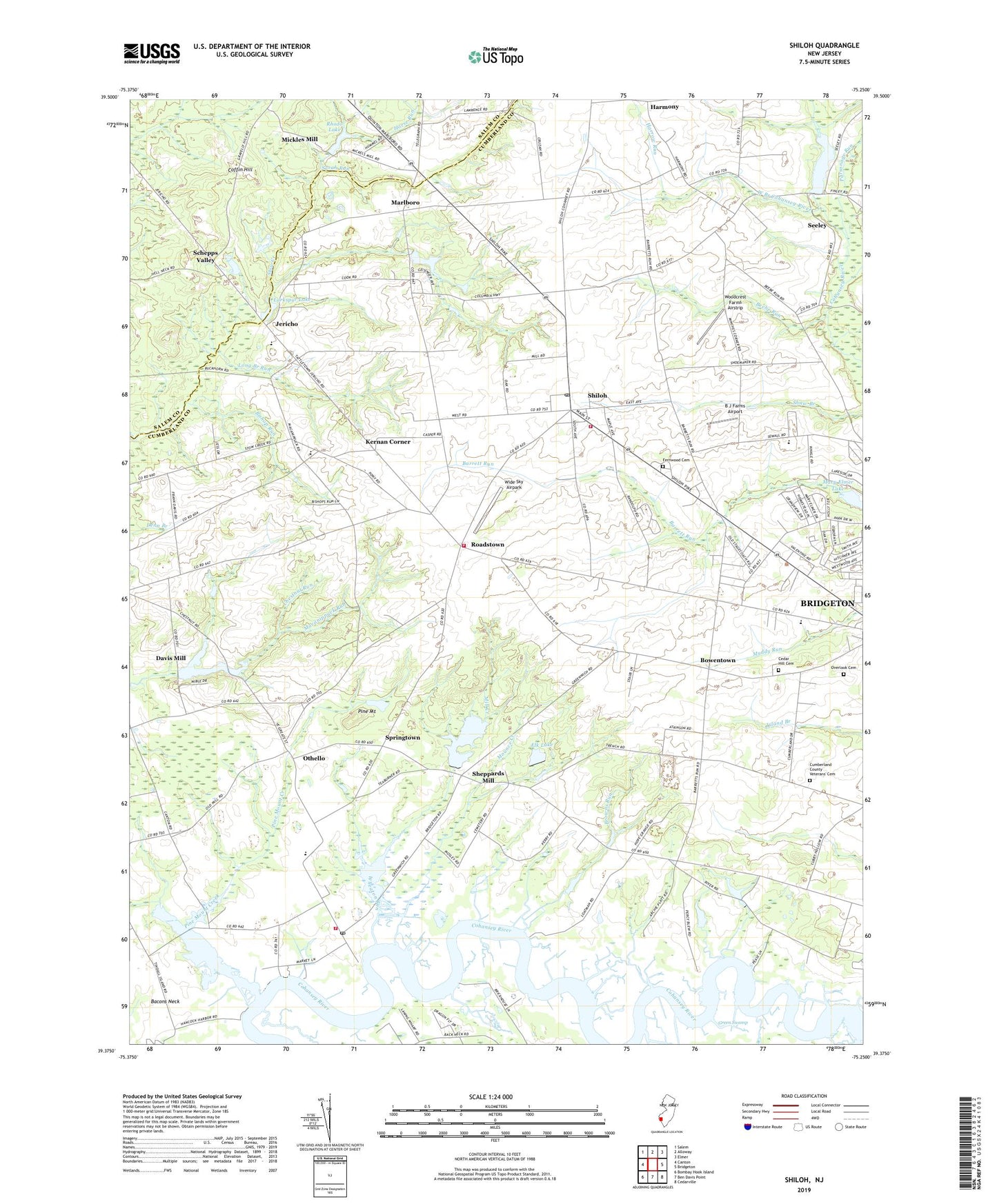
2023 topographic map quadrangle Shiloh in the state of New Jersey. Scale: 1:24000. Based on the newly updated USGS 7.5' US Topo map series, this map is in the following counties: Cumberland, Salem. The map contains contour data, water features, and other items you are used to seeing on USGS maps, but also has updated roads and other features. This is the next generation of topographic maps. Printed on high-quality waterproof paper with UV fade-resistant inks.
Quads adjacent to this one:
West: Canton
Northwest: Salem
North: Alloway
Northeast: Elmer
East: Bridgeton
Southeast: Cedarville
South: Ben Davis Point
Southwest: Bombay Hook Island
This map covers the same area as the classic USGS quad with code o39075d3.
Contains the following named places: Arrowhead Lake, Arrowhead Lake Census Designated Place, B J Farms Airport, Barrett Run, Beebe Run, Bishop Run, Borough of Shiloh, Bowentown, Browns Run, Campbells Corner, Cedar Hill Cemetery, Chestnut Run, Coffin Hill, Cumberland County Juvenile Detention Center, Cumberland County Veterans' Cemetery, Davis Mill, Davis Millpond, Davis Millpond Dam, Devereux New Jersey Center School, Dickerson Corner, Dutch Neck, Dutch Neck Census Designated Place, Elk Lake, Elk Lake Dam, Fernwood Cemetery, Fithians Corner, Green Swamp, Greenwich, Greenwich Census Designated Place, Greenwich Pier, Greenwich Post Office, Greenwich Township Fire and Rescue, Hands Pond, Harmony, Harrow Run, Hopewell - Stow Creek Fire Department, Hopewell Crest Elementary School, Hopewell School, Horse Run, Jericho, Jericho Pond, Jericho Pond Dam, Kernan Corner, Laning Wharf, Larkspur Lake, Long Branch Run, Macanippuck Run, Marlboro, Marlboro Census Designated Place, Marlboro Church, Mary Elmer Lake, Mickles Mill, Mickles Mill Dam, Mill Creek, Morris Goodwin Elementary School, Mounce Creek, Othello, Othello Census Designated Place, Overlook Cemetery, Parsonage Run, Pine Mount, Pine Mount Creek, Rhodo Lake, Roadstown, Roadstown Census Designated Place, Sarah Run, Schepps Valley, Seeley, Seeley Pond, Seventh Day Mill, Sheppards Mill, Sheppards Mill Census Designated Place, Sheppards Millpond, Sheppards Millpond Dam, Shiloh, Shiloh Elementary School, Shiloh Fire and Rescue, Shiloh Post Office, Springtown, Stow Creek School, Sunny Slope Farms of New Jersey, Town Hall, Township of Greenwich, Township of Hopewell, Township of Stow Creek, West Branch Cohansey River, West Park, West Park Census Designated Place, Wheaton Run, Wide Sky Airpark, WNNN-FM (Canton), Woodcrest Farms Airstrip, Woodland Country Day School, ZIP Codes: 08302, 08323, 08353