MyTopo
Bernalillo New Mexico US Topo Map
Couldn't load pickup availability
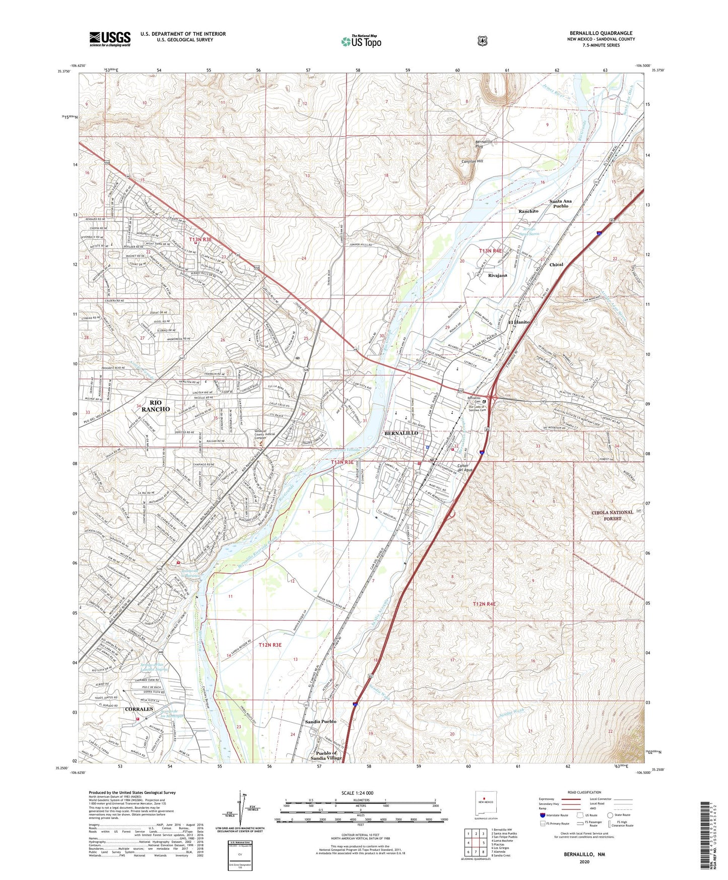
2020 topographic map quadrangle Bernalillo in the state of New Mexico. Scale: 1:24000. Based on the newly updated USGS 7.5' US Topo map series, this map is in the following counties: Sandoval. The map contains contour data, water features, and other items you are used to seeing on USGS maps, but also has updated roads and other features. This is the next generation of topographic maps. Printed on high-quality waterproof paper with UV fade-resistant inks.
Quads adjacent to this one:
West: Loma Machete
Northwest: Bernalillo NW
North: Santa Ana Pueblo
Northeast: San Felipe Pueblo
East: Placitas
Southeast: Sandia Crest
South: Alameda
Southwest: Los Griegos
Contains the following named places: 10001 Water Well, 10002 Water Well, 10003 Water Well, 10006 Water Well, 10007 Water Well, 10019 Water Well, 87004, Abenicio Salazar Historic District, Albuquerque Main Canal, Albuquerque Main Canal Wasteway, Algodones Ditch, All Tribes Indian Mission School, Anasazi Trails, Arroyo Agua Sarca, Arroyo de la Baranca, Arroyo de las Lomitas Negras, Arroyo de los Montoyas, Arroyo Venada, Barrios for Jesus Church, Bernalillo, Bernalillo Acequia, Bernalillo Cemetery, Bernalillo Fire Department, Bernalillo High School, Bernalillo Independent Baptist Church, Bernalillo Interior Drain, Bernalillo Middle School, Bernalillo on the Camino Real Historical Marker, Bernalillo Plug, Bernalillo Police Department, Bernalillo Post Office, Bernalillo Riverside Drain, Bernalillo United Methodist Church, Bernalillo Weather Station, Bernallilo Church of Christ, Bosque Lateral Number One, Bosque Lateral Number Two, Canjilon Hill, Canon del Agua, Carrol Elementary School, Celebration Baptist Church, Charity Baptist Church, Chical, Church of the Incarnation, Coronado Pit, Coronado State Monument, Coronado State Monument Historical Marker, Coronado State Monument Kuaua Ruins, Covenant Christian Church, Desert Mountain, El Chapparal, El Llanito, El Ranchito Grant, Enchanted Hills Elementary School, Felipe Gutierres or Bernalillo Grant, First Assembly of God Church, First Baptist Church, Jemez River, KKTT-AM (Bernalillo), Kuaua, Las Cocinitas, Martha Liebert Library, Montoya-Gallegos House, Mountain View Middle School, North Pit, North Valley Assembly of God Church, Our Lady of Sorrows Catholic Church, Our Lady of Sorrows Cemetery, Our Lady of Sorrows Convent Historic Site, Our Lady of Sorrows School, Pilgrim Indian Mission School, Pueblo of Sandia Village, Pueblo of Sandia Village Census Designated Place, Pueblo Santiago, Ranchito, Ranchitos Drain, RG-34422 Water Well, Rio Rancho Division, Rio Rancho Estates Detention Basin Number Four Dam, Rio Rancho Estates Detention Basin Number One Dam, Rio Rancho Fire and Rescue Station 3, Rio Rancho Fire and Rescue Station 5, Rio Rancho Poe Post Office, Rio West, Rivajana, Roosevelt Elementary School, San Felipe Pueblo Elementary, Sandia Acequia, Sandia Mountain Tributaries Site Dam, Sandia Pueblo, Sandia Pueblo Grant, Sandia Pueblo Resource Center Library, Sandia Wash, Sandoval County Courthouse, Sandoval County Fire Department, Sandoval County Fire Department Administration, Sandoval County Sherriff's Office, Santa Ana Detention Dam, Santa Ana Pueblo Census Designated Place, Santa Ana School, Santa Ana Star Casino, Shepherd of the Hills Lutheran Church, Spanish Estrada Site, Town of Bernalillo, Valle Grande Golf Course, Village of Corrales Fire Station 2