MyTopo
Freeport New York US Topo Map
Couldn't load pickup availability
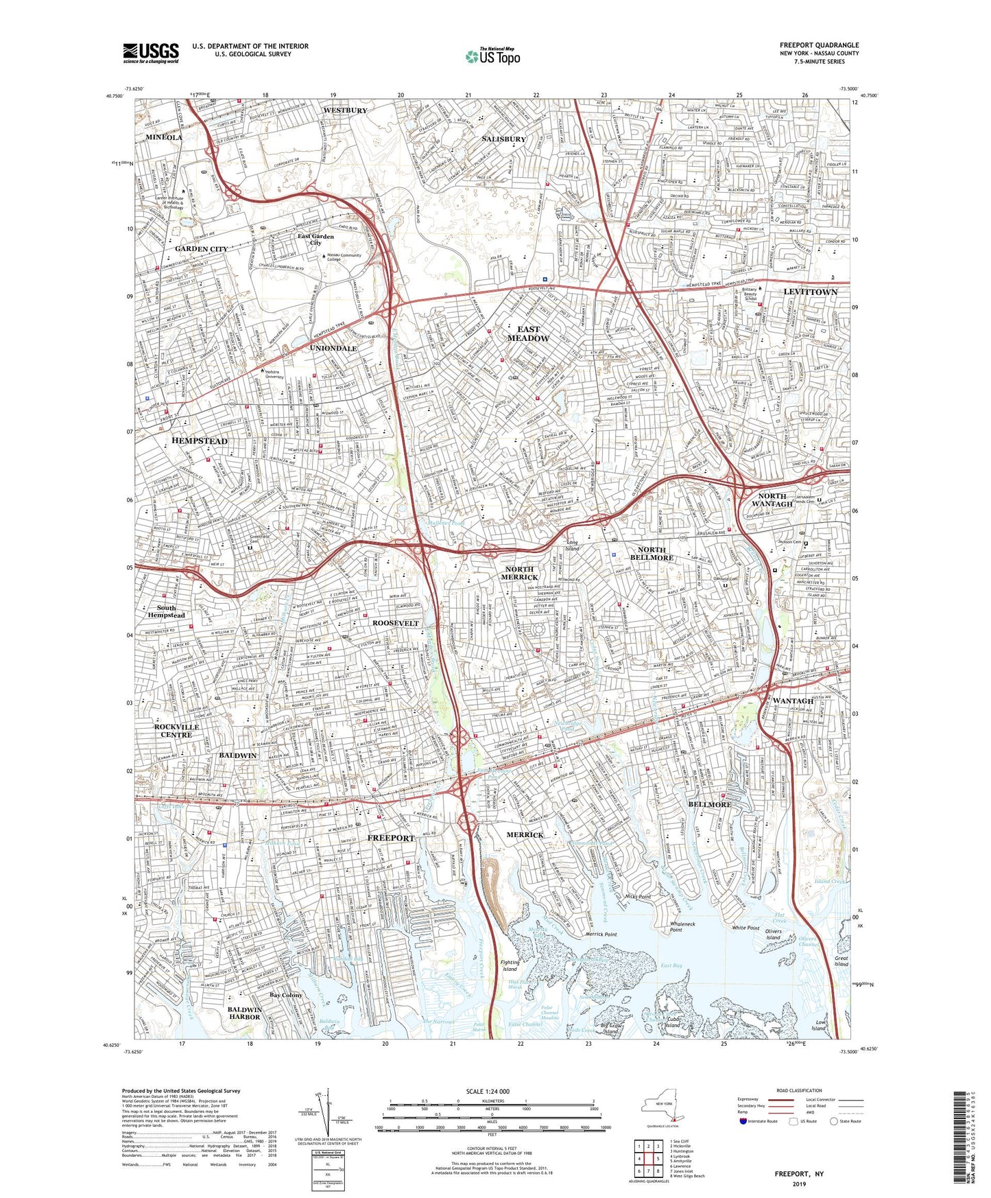
2019 topographic map quadrangle Freeport in the state of New York. Scale: 1:24000. Based on the newly updated USGS 7.5' US Topo map series, this map is in the following counties: Nassau. The map contains contour data, water features, and other items you are used to seeing on USGS maps, but also has updated roads and other features. This is the next generation of topographic maps. Printed on high-quality waterproof paper with UV fade-resistant inks.
Quads adjacent to this one:
West: Lynbrook
Northwest: Sea Cliff
North: Hicksville
Northeast: Huntington
East: Amityville
Southeast: West Gilgo Beach
South: Jones Inlet
Southwest: Lawrence
Contains the following named places: Abbey Lane School, Alder Canal, Archer Street Elementary School, Aviation Country Club Airport, Baldwin, Baldwin Bay, Baldwin Census Designated Place, Baldwin Golf Course, Baldwin Harbor, Baldwin Harbor Census Designated Place, Baldwin Harbor Town Park, Baldwin High School, Baldwin Junior High School, Baldwin Middle School, Baldwin Station, Barnum Woods School, Bay Colony, Bayview Avenue School, Beach Canal, Beechwood School, Bellmore, Bellmore Canal, Bellmore Census Designated Place, Bellmore Creek, Bellmore Maintenance Facility, Bellmore Station, Bideawee Pet Memorial Park, Birch School, Bloomingdale School, Bowling Green School, Brierley Park, Brooklyn Pumping Station, Brookside Elementary School, Brookside Junior High School, Brookside Preserve, Bunkers Lake, California Avenue Elementary School, Cammanns Pond County Park, Camp Avenue School, Camp Mills, Carle Place Census Designated Place, Carle Place Park, Caroline G Atkinson School, Cedar Creek County Park, Cedar Creek Water Pollution Control Plant, Cedar Street School, Cedar Swamp Creek, Centennial Avenue School, Centennial Park, Cherrywood School, Cleveland Avenue School, Clinton Station, Club House Canal, Coes Neck Park, Columbus Avenue School, Coolidge School, Cornelius Court School, Cow Meadow Preserve, Cure of Ars School, Daurenheim Estate, Division Avenue High School, Doctors Hospital, Dutch Lane School, EAB Plaza Heliport, East Bay, East Canal, East Garden City, East Garden City Census Designated Place, East Island, East Meadow, East Meadow Brook, East Meadow Census Designated Place, East Meadow Pond, East Village Green, Eisenhower Memorial Park, Eisenhower Park Golf Course, Emory Creek, False Channel Meadow, Fighting Island, Flat Creek, Forest City Park, Freeport, Freeport Armory, Freeport Creek, Freeport Disposal Plant, Freeport Marina, Freeport Stadium, Freeport Station, Great Island, Greenfield Cemetery, Gunther Field, Hairpin Canal, Harry D Daniels Elementary School, Hempstead, Hempstead Plains Preserve, Hempstead Sewage Disposal Plant, Hempstead Town Home Hospital, Henry Street Park, High Flats Marsh, Hudson Channel, Island Creek, Island Heliport, Jackson Cemetery, James M Shuart Stadium, Jersalem Avenue Field, Jerusalem Friends Cemetery, John W Dodd Middle School, Julian Lane Park, Kennedy Memorial Park, Landing Canal, Levittown, Levittown Census Designated Place, Lincoln Park, Loffs Lake, Lotts Pond County Park, Low Island, Meadow Brook Country Club, Meadow Brook Polo Field, Medical Center Heliport, Meroke Preserve, Merrick, Merrick Bay, Merrick Census Designated Place, Merrick Creek, Merrick Golf Course, Merrick Point, Merrick Road Park, Merrick Station, Milburn Creek, Milburn Creek Park, Milburn Pond, Milburn Pumping Station, Millburn, Millpond Park, Mitchell Air Force Base, Mud Creek, Mullener Pond, Nassau Airport, Nassau County, Nassau County Veterans Memorial Coliseum, Nassau University Medical Center, Naval Air Facility Roosevelt Field, Neds Creek, Neds Meadow, Newbridge Canal, Newbridge Creek, Newbridge Pond, Newbridge Road Park, Nicks Point, North Bellmore, North Bellmore Census Designated Place, North Canal, North Merrick, North Merrick Census Designated Place, North Village Green, North Wantagh, North Wantagh Census Designated Place, Northeast Park, Northwest Park, Oakfield Cemetery, Old Camp Meeting Grounds, Old Westbury Golf Club, Olivers Channel, Olivers Island, Parsonage Cove, Parsonage Creek, Polaris Field, Randall Bay, Randall Memorial Park, Roosevelt, Roosevelt Census Designated Place, Roosevelt Field, Roosevelt Field Shopping Center, Roosevelt Park, Roosevelt Raceway, Salisbury, Salisbury Census Designated Place, Salisbury Links, Seabreeze Canal, Seaman Pond, Seasons of East Meadow, Silver Lake Park, Simmond Creek, Simmonds Pond, Smith Pond, South Canal, South Hempstead, South Hempstead Census Designated Place, South Village Green, Stadium Park Canal, Sunrise Yacht Club, The Narrows, The Source Mall Shopping Center, Town of Hempstead, Uniondale, Uniondale Census Designated Place, Uniondale Park, Veterans Memorial Park, Village of Freeport, Village of Hempstead, W Tresper Clarke High School, Wantagh, Wantagh Census Designated Place, Wantagh County Park, Wantagh Pond, Wantagh Reservoir, Wantagh Station, Waterfront Park, Waukena Waterway, WBAB-AM (Freeport), WBAU-FM (Garden City), West Village Green, WGBB, Whaleneck Point, White Point, WHLI-AM (Hempstead), WHPC-FM (Garden City), William S Covert School, WKJY-FM (Hempstead), Woodclift Canal, WRHU-FM (Hempstead), WTHE-AM (Mineola), ZIP Codes: 11510, 11514, 11520, 11549, 11550, 11553, 11554, 11556, 11566, 11575, 11710, 11756, 11793