
MyTopo
Fulton New York US Topo Map
Couldn't load pickup availability
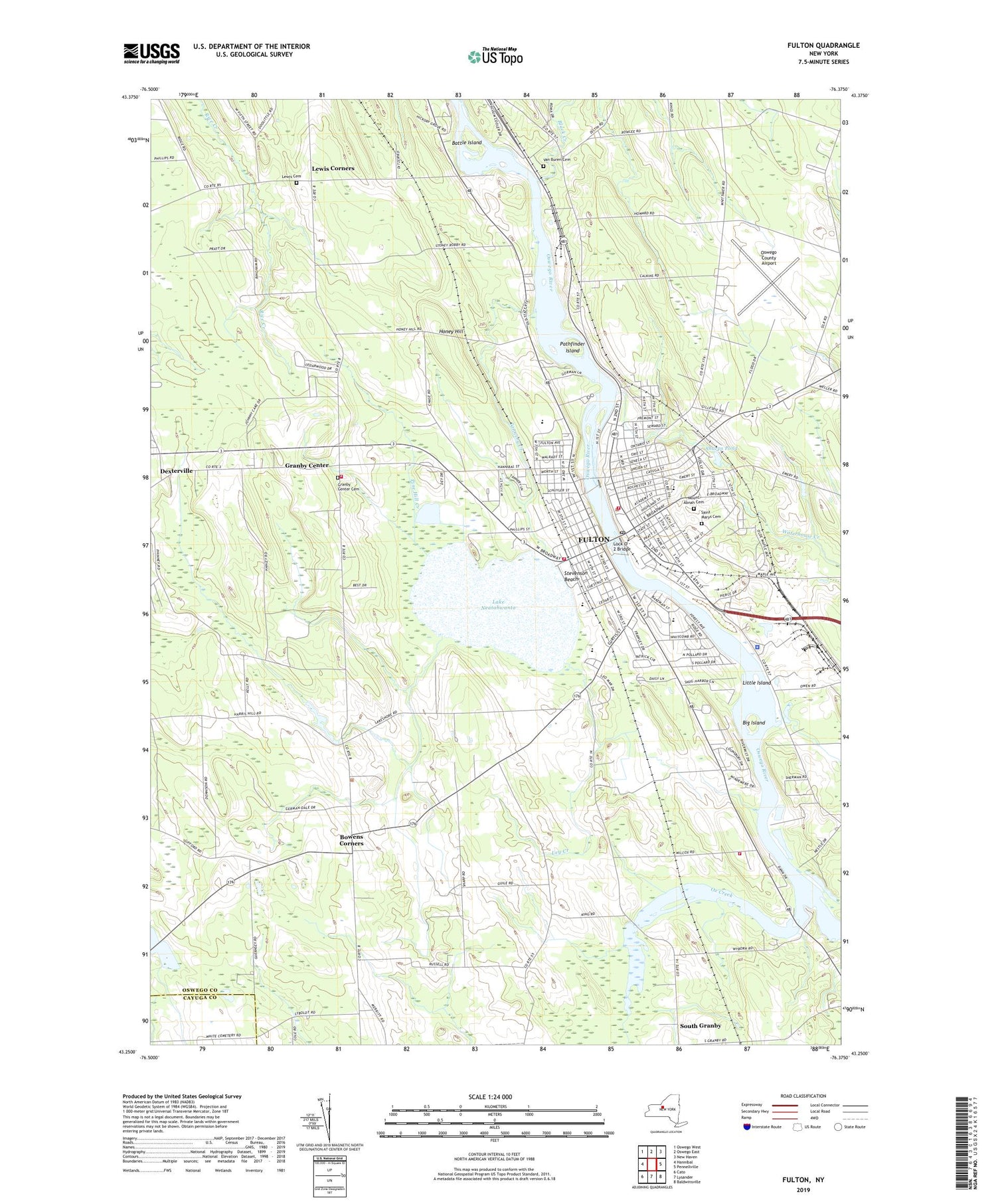
2019 topographic map quadrangle Fulton in the state of New York. Scale: 1:24000. Based on the newly updated USGS 7.5' US Topo map series, this map is in the following counties: Oswego, Cayuga. The map contains contour data, water features, and other items you are used to seeing on USGS maps, but also has updated roads and other features. This is the next generation of topographic maps. Printed on high-quality waterproof paper with UV fade-resistant inks.
Quads adjacent to this one:
West: Hannibal
Northwest: Oswego West
North: Oswego East
Northeast: New Haven
East: Pennellville
Southeast: Baldwinsville
South: Lysander
Southwest: Cato
Contains the following named places: A E Lee Memorial Hospital, All Saints Episcopal Church, Battle Island, Battle Island State Park, Battle Island State Park Golf Course, Believer's Chapel of Fulton, Big Island, Black Creek, Bowens Corners, Bowens Corners Methodist Church, Calvary Baptist Church, Canal Landing Marina - Fulton, Christian And Missionary Alliance Church, Christian Assembly Church, Church of the Nazarene, City of Fulton, Cody Fire Department Station 2, Crosby Hill Mobile Home Park, Crossroads Tabernacle, Dexterville Seventh Day Adventist Church, Dexterville Seventh Day Adventist Church School, Eason Mobile Home Park, Erie Street School, Evergreen Knoll Farm, Fairgraves Junior High School, First Church of Christ Scientist, First Congregational Church, First Methodist Church, First Presbyterian Church, First United Church of Fulton, Foster Park, Fox Meadow Mobile Home Park, Free Methodist Church, Fulton, Fulton Alliance Church, Fulton Christian Fellowship, Fulton City Hall, Fulton Fire Department East Side Fire Station, Fulton Fire Department West Side Fire Station, Fulton First United Methodist Church, Fulton High School, Fulton Junior High School, Fulton Post Office, Fulton Public Library, Fulton Water Works, G Ray Bodley High School, Grace Bible Baptist Church, Granby Center, Granby Center Cemetery, Granby Center Methodist Church, Granby Center Volunteer Fire Department, Granby Elementary School, Granby Town Hall, Honey Hill, Immaculate Conception Roman Catholic Church, J E Lanigan School, James R Fairgrieve School, Kallet-State Theatre, Kerfien's Mobile Home Park, Kingdom Hall of Jehovah's Witnesses, Lake Neatahwanta, Lewis Cemetery, Lewis Corners, Ley Creek, Little Island, Lock Number 2, Lock Number 3, Lock O - 2 Bridge, Mount Abnah Cemetery, Oak Street School, Oswego Canal, Oswego County Airport, Oswego County Ambulance Service, Ox Creek, Pathfinder Island, Phillips Street Junior High School, Pine Hill Creek, Prince of Peace Evangelical Lutheran Church, Reformed Presbyterian Church of North America, River of Life Assembly of God, Saint Marys Cemetery, Saint Mary's Roman Catholic School, Saint Michael's Roman Catholic Church, School Number 1, School Number 12, School Number 13, School Number 14, School Number 15, School Number 17, School Number 3, School Number 5, School Number 7, School Number 8, School Number 9, Sharps Pond, Snow Valley Honey Farm, South Granby, State Street Methodist Church, State Street School, Stevenson Beach, Tannery Creek, Town of Granby, Van Buren Cemetery, Volney Elementary School, Walradt Street School, War Memorial Building, Waterhouse Creek, Willow Creek Farm, WZZZ-AM (Fulton), ZIP Code: 13069


