MyTopo
Lloyd Harbor New York US Topo Map
Couldn't load pickup availability
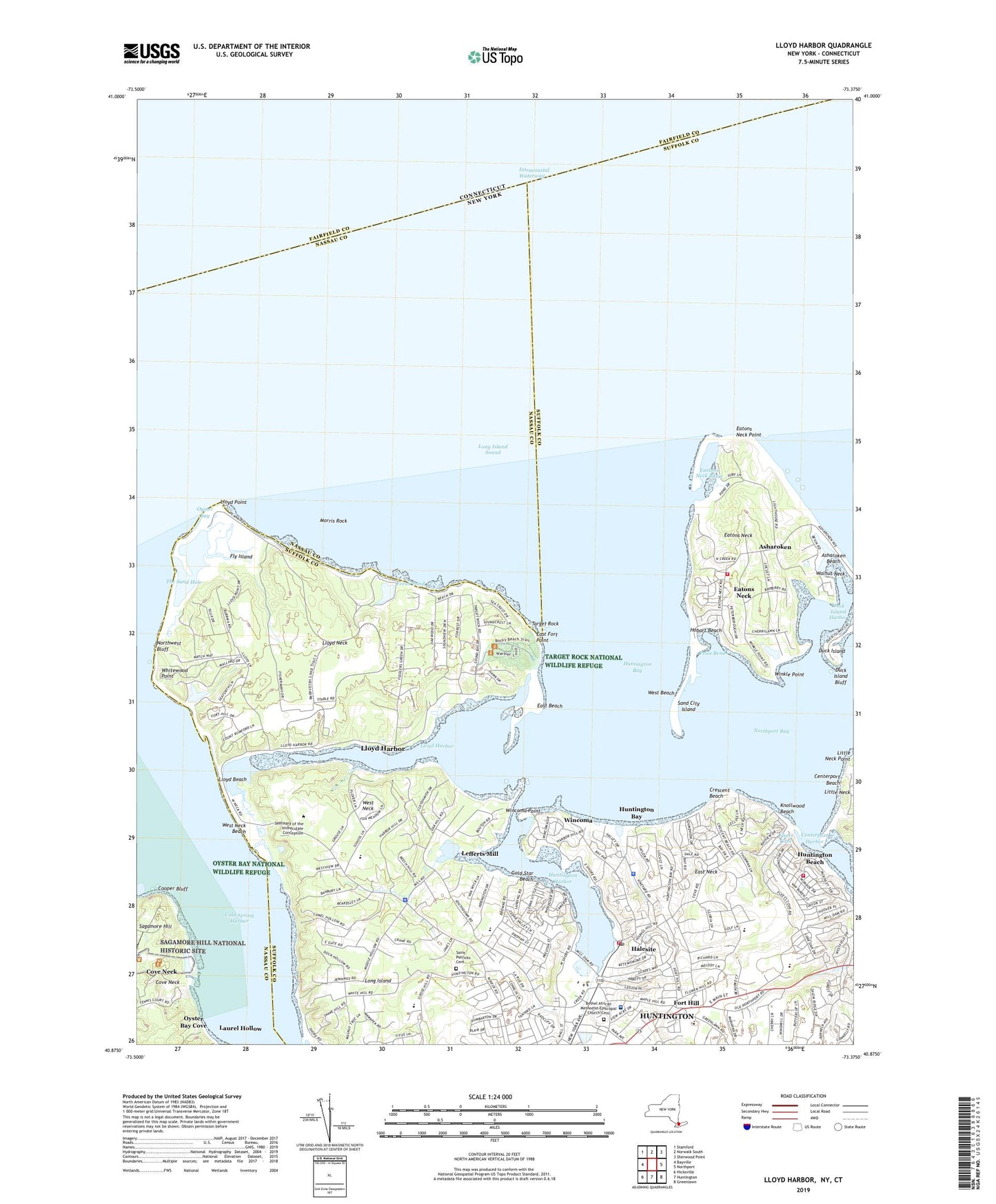
2019 topographic map quadrangle Lloyd Harbor in the state of New York. Scale: 1:24000. Based on the newly updated USGS 7.5' US Topo map series, this map is in the following counties: Suffolk, Nassau, Fairfield. The map contains contour data, water features, and other items you are used to seeing on USGS maps, but also has updated roads and other features. This is the next generation of topographic maps. Printed on high-quality waterproof paper with UV fade-resistant inks.
Quads adjacent to this one:
West: Bayville
Northwest: Stamford
North: Norwalk South
Northeast: Sherwood Point
East: Northport
Southeast: Greenlawn
South: Huntington
Southwest: Hicksville
Contains the following named places: American Legion Post 360, Bethel African Methodist Episcopal Church, Bethel African Methodist Episcopal Church Cemetery, Caumsett State Park, Centerpoint Park, Centerport, Centerport Beach, Centerport Fire Department, Centerport Harbor, Coast Guard Station Northport, Coindre Hall, Coindre Hall Park, Cold Spring Harbor, Cold Spring Harbor Beach Club, Columbia Grove, Congregational Church of Huntington, Cooper Bluff, Cove Neck, Cove Neck Heliport, Crescent Beach, Crystal Lake, Duck Island, Duck Island Bluff, Duck Island Harbor, E Robinson Estate, East Beach, East Fort Point, East Neck, East Side School, Eastons Neck Basin, Eatons Neck, Eatons Neck Census Designated Place, Eaton's Neck Fire Department, Eatons Neck Light, Eatons Neck Point, Eberstadt, Finley Middle School, Fiske Bird Sanctuary, Fleets Cove, Flower Hill Primary School, Fly Island, Fort Hill, Fresh Pond, Friends World College, G M Livingston Estate, Gold Star Beach, Halesite, Halesite Census Designated Place, Halesite Fire Station, Halesite Park, Halesite Post Office, Hecksher Park, Hobart Beach, Huntington Bay, Huntington Bay Club, Huntington Bay Police Department, Huntington Beach, Huntington Census Designated Place, Huntington Country Club, Huntington Crescent Club, Huntington Disposal Plant, Huntington Emergency Helistop, Huntington Harbor, Huntington Harbor Light, Huntington Hospital, Huntington Sewage Treatment Plant, Huntington Town Dock, Huntington Yacht Club, Immaculate Conception Seminary, Industrial Home of the Blind, Jennings Field, Kingdom Hall of Jehovahs Witnesses, Knollwood Beach, Kotewomake Yacht Club, Lefferts Mill, Little Neck Point, Lloyd Beach, Lloyd Harbor, Lloyd Harbor Elementary School, Lloyd Harbor Police Department, Lloyd Harbor Village Hall, Lloyd Harbor Village Park, Lloyd Neck, Lloyd Neck Beach Club, Lloyd Point, Marshall Field Estate, Matherson Estate, Mill Cove Waterfowl Sanctuary, Mill Dam Marina and Ramps, Mill Dam Park, Morris Rock, Nathan Hale School, Nike Site NY-20C, Nike Site NY-20L, North Shore Holiday House, Northwest Bluff, Old Orchard Museum, Oyster Bay, Price Bend, Queens College Center For Environmental Studies, Sagamore Hill National Historic Site, Saint Patricks Cemetery, Sand City Island, Shepherd School, Southdown Primary School, Target Rock, Target Rock National Wildlife Refuge, The Meadows, The Sand Hole, Town of Huntington, Unitarian Universalist Church, Village of Asharoken, Village of Cove Neck, Village of Huntington Bay, Village of Lloyd Harbor, W Jennings Estate, W L Smith Estate, Walnut Neck, Washington Drive School, West Beach, West Neck, West Neck Beach, West Shore Marina, Whitewood Point, William B Leeds Estate, Wincoma, Wincoma Point, Winkle Point, Wyncote Club Marina, ZIP Code: 11743