MyTopo
Norwalk South Connecticut US Topo Map
Couldn't load pickup availability
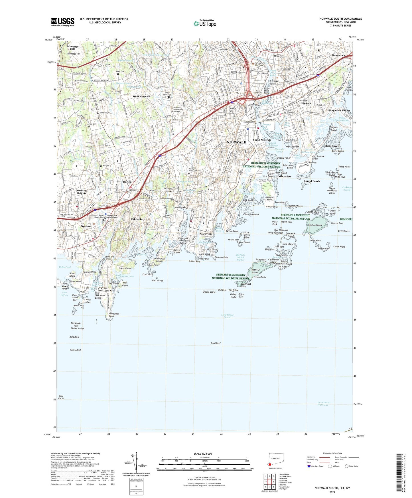
2024 topographic map quadrangle Norwalk South in the state of Connecticut. Scale: 1:24000. Based on the newly updated USGS 7.5' US Topo map series, this map is in the following counties: Fairfield, Suffolk. The map contains contour data, water features, and other items you are used to seeing on USGS maps, but also has updated roads and other features. This is the next generation of topographic maps. Printed on high-quality waterproof paper with UV fade-resistant inks.
Quads adjacent to this one:
West: Stamford
Northwest: Pound Ridge
North: Norwalk North
Northeast: Westport
East: Sherwood Point
Southeast: Northport
South: Lloyd Harbor
Southwest: Bayville
This map covers the same area as the classic USGS quad with code o41073a4.
Contains the following named places: 50 Washington Street Heliport, Baker Park, Ballast Reef, Bayley Beach Park, Beers Rocks, Bell Cemetery, Bell Island, Bermuda Lagoon, Betts Island, Betts Pond Brook, Bishop Mill Pond, Bluff Point, Bold Rock, Boston Post Road Historic District, Bradlees Shopping Center, Brush Island, Budd Reef, Butlers Island, Calf Pasture Beach, Calf Pasture Beach City Park, Calf Pasture Island, Calf Pasture Park, Calf Pasture Point, Canfield Island, Cedar Hammock, Chalmers Pond, Charles Creek, Chasmars Pond, Chasmars Pond Dam, Cherry Lawn Park, Chimon Island, Chimon Rock, City of Norwalk, Colyer Point, Contentment Island, Copps Island, Copps Rocks, Country Club of Darien, Cove Harbor, Cove Rocks, Crab Island, Crow Island, Darien, Darien Census Designated Place, Darien Downtown Census Designated Place, Darien Shopping Center, Darien Station, Darinor Shopping Plaza Shopping Center, Dog Island, East Norwalk, East Norwalk Cemetery, East Norwalk Harbor, East Norwalk Station, East White Rock, Farm Creek, Ferry Point, Ferry Point Reach, Fish Islands, Fitch Point, Fivemile River, Flax Hill Park, Florshiem Pond, Goeller Cove, Golden Hill, Goodwives River, Goodwives Shopping Plaza Shopping Center, Gorhams Pond, Grassy Hammock Rocks, Grassy Island, Great Island, Great Reef, Greens Ledge, Greens Ledge Lighthouse, Gregory Point, Harbor Ledge, Harbor View Beach, Harborview, Hay Island, Hebrew Cemetery, Hiding Rocks, Holly Pond, Holy Ghost Fathers Brook, Holy Ghost Fathers Pond, Hoyt Cemetery, Hoyt Island, Isaac Street Plaza Shopping Center, Ischoda Yacht Club, Jennie Jenks Park, Jennings Point, Judy Point, Keelers Brook, Keyser Point, Landmark Square Shopping Center, L'Hammock Island, Liberty Point, Little Hammock Island, Little Ram, Little Tavern Island, Long Beach, Long Neck, Long Neck Point, Manresa Island, Marvin Beach, Mather Fields, Mathers Pond, Mathers Pond Dam, Mathews Park, McGuane Field, Mill Pond, Millard Pond, Millard Pond Dam, Nash Island, Nat Clocks Rock, Ned Island, Norden Systems Heliport, Norfolk River Reach, Noroton, Noroton Census Designated Place, Noroton Heights, Noroton Heights Census Designated Place, Noroton Heights Shopping Center, Noroton Neck, Noroton Point, Noroton Station, Noroton Yacht Club, Norwalk, Norwalk Country Club, Norwalk Cove Marina, Norwalk Factory Outlet Center Shopping Center, Norwalk Green, Norwalk Harbor, Norwalk Islands, Norwalk Mall Shopping Center, Norwalk River, Norwalk Station, Norwalk Yacht Club, Oak HIlls Park Golf Course, Old Baldy, Old Pelt, Ox Ridge Hunt Club, Oyster Shell Point, Oyster Shell Reach, Peach Island, Pear Tree Point, Pear Tree Point Beach, Pear Tree Point Cove, Pine Island Cemetery, Pine Point, Pratt Island One, Pratt Island Two, Ram Bay, Raymond Cemetery, Raymond Rocks, Rings End Bridge, Riverside Cemetery, Rogers Reef, Roton Point, Round Beach, Rowayton, Rowayton Cemetery, Rowayton Community Beach, Rowayton Station, Rowayton Union Cemetery, Saint John Beach, Saint Johns Cemetery, Saint Pauls Cemetery, Sandy Hammock, Sasqua Hill, Saugatuck Harbor Yacht Club, Scott Cove, Seaview Park, Seaview Park Reach, Selleck Woods, Shea Island, Sheep Rocks, Sheffield Island, Sheffield Island Harbor, Shore and Country Club, Shorehaven, Shovehaven Golf Course, Slasson Cemetery, Smith Beach Harbor, Smith Reef, Sound View Point, South Main and Washington Street Historic District, South Norwalk, South Norwalk Boat Club, South Norwalk Station, Southwest Point, Spring Grove Cemetery, Spring Grove Veterans Cemetery, Spring Hill, Springwood Park, Sprite Island, Sprite Island Yacht Club, Spruce Swamp Pond, Stony Brook, Stony Brook Park, Streets Pond, Talmadge Hill, Tavern Island, Taylor Farm, The Ballast, The Gut, The Plans, Tilley Pond Park, Tokeneke, Tokeneke Census Designated Place, Tokeneke Park, Town of Darien, Town of Norwalk, Tree Hammock, Village Creek, Waterbury Cemetery, Waveny Park, Wee Burn Country Club, Weed Beach, Weed Beach Park, Weed Cemetery, WEFX-FM (Norwalk), West Norwalk, White Rock, Wilson Cove, Wilson Point, WNLK, WNLK-AM (Norwalk), Wood Island, Yellow Rock, Yellow Rocks, Zieglers Cove, ZIP Codes: 06820, 06853, 06854, 06855, 06856