MyTopo
Brevard North Carolina US Topo Map
Couldn't load pickup availability
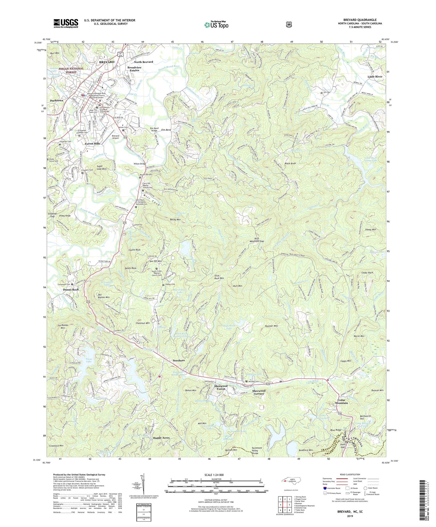
2019 topographic map quadrangle Brevard in the state of North Carolina. Scale: 1:24000. Based on the newly updated USGS 7.5' US Topo map series, this map is in the following counties: Transylvania, Greenville. The map contains contour data, water features, and other items you are used to seeing on USGS maps, but also has updated roads and other features. This is the next generation of topographic maps. Printed on high-quality waterproof paper with UV fade-resistant inks.
Quads adjacent to this one:
West: Rosman
Northwest: Shining Rock
North: Pisgah Forest
Northeast: Horse Shoe
Southeast: Cleveland
South: Table Rock
Contains the following named places: Arrowhead Dam, Arrowhead Lake, Artimus Owens Dam, Atagahi Lake, Atagahi Lake Dam, Beckworth Hill, Becky Mountain, Betty Kay Lake Dam, Betty-Kay Lake, Big Branch, Bill Raines Mountain, Black Knob, Blue Ridge Community College - Transylvania, Blue Ridge Overlook, Boot Lake, Boot Lake Dam, Bradford Mountain, Brevard, Brevard Airport, Brevard College, Brevard Country Club and Golf Course, Brevard Davidson River Presbyterian Church Memorial Garden, Brevard Elementary School, Brevard Fire Department, Brevard High School, Brevard Middle School, Brevard Police Department, Brevard Post Office, Brevard Rescue Squad, Brevard Shopping Center, Broadview Estates, Brushy Creek, Buck Forest, Buckhorn Creek, Burl Mountain, Burnt Mountain, Camp Burgess Glen Dam, Camp Burgess Glen Lake, Camp Burgiss Glen, Camp Creek, Camp Deerwoode, Cannon Creek, Capps Mountain, Carr Hill Church, Carrs Hill Baptist Church Cemetery, Carson Creek Church, Cascade Lake, Cascade Lake Dam, Castle Rock, Cedar Mountain, Cedar Mountain Post Office, Cedar Mountain Volunteer Fire Rescue, Cedar Rock, Chestnut Mountain, Chestnut Square, City of Brevard, Clear Creek, College Shopping Center, Connestee Cemetery, Connestee Falls, Connestee Fire Rescue Main Station, Connestee Fire Rescue Upper Station, Coopers Cemetery, Cox Branch, Crab Creek, Deerwoods Estates, Dehon Mountain, Dodsworth Spring, Ducktown, Duncan Creek, Dunns Creek, Dunns Creek Baptist Church Cemetery, Dunns Creek Church, Dunns Rock, Eagles Nest Dam, Eagles Nest Lake, East Fork Laurel Creek, Elm Bend, Elm Bend Bridge, Emerald Hills Estates, Evergreen Gillespie Cemetery, Faith Memorial Chapel, Falls Creek, Fernwood, Forest Hills, Franklin Park, Full Gospel Church, Gay Valley Camp, Glazener Cemetery, Glazener Gap, Glen Cannon, Glencannon Falls, Graham Creek, Greenville Elks Childrens Camp, Hamilton Estates, Hanty Branch, Happy Acres, Hart Branch, Hawkins Branch, Hemlock Lake, Hidden Valley, High Rock Dam, High Rock Lake, High Rocks Camp, Hogsed Creek, Holden Cemetery, Hunts Branch, Ibby Creek, Jim Raines Mountain, Johnson Branch, Jones Gap, King - Old Town Cemetery, King Creek, Knob Branch, Knob Creek, Knob Hill, Knob Ridge, Lake Arrowhead, Lake Taroga, Lake Tiaroga Dam, Lamb Creek, Lambo Creek, Laurel Creek, Linden Tree Manor, Little River, Little River Camp Dam, Little River Camp Lake, Little River Chapel, Loehencove Ridge, Long Branch, Long Lake, Looking Glass Montessori School, Maidenhair Falls, Marchmans Dam, Marchmans Lake, McCall Branch, McCrary Acres, McCrary Branch, McGaha Cemetery, Merrill Creek, Middle Mountain, Mill Cove, Millbrook Estates, Morgan Creek, Morgan Heights, N Shore Lake, N Shore Lake Dam, Nicholson Creek, Noname, North Brevard, Norton Creek, Orchard Branch, Orr Cemetery, Orr Spring, Panther Mountain, Patton Mountain Estates, Phillips Creek, Piedmont Lake, Pine Shore Lakes, Piney Knob, Pisgah Forest Farms, Pole Bridge Branch, Quillen Mountain, Red House Inn, Rich Mountain, Rich Mountain Gap, Riverside Estates, Rockbrook Camp, Rocky Hill Church, Rosenwald School, Round Top Cemetery, Saint Paul's in the Valley Episcopal Cemetery, Saint Philip's Episcopal Church Cemetery, See Off Mountain, Seeshore, Sequoyah Woods, Sequoyah Woods Lake, Sequoyah Woods Lake Dam, Seven Springs, Shady Grove Cemetery, Sheep Mountain, Sherwood Forest, Sherwood Ridge, Sherwood Terrace, Slick Rock, Slick Rock Mountain, Slick Rock Mountain Dam, Slick Rock Mountain Lake, Sonata Lake, South Prong Little River, Steel Creek, Stoney Brook, Straus Elementary School, Straus School, Sugar Loaf Mountain, Sweetwater Farms, T J Wilson Lake, Tar Heel Lake, Tarheel Lake, Tarheel Lake Dam, The Inn at Brevard, Thunder Lake, Thunder Lake Dam, Ticoa Dam, Ticoa Lake, Tom Creek, Township of Dunns Rock, Township of Little River, Transylvania County Emergency Medical Services, Transylvania County Rescue Squad, Trout Lake, Trout Lake Dam, W Cantrell Dam, W Cantrell Lake, Walker Creek, WHNS-TV (Asheville), Williamson Creek, Wilson Bridge, Wilson Cemetery, WPNF-AM (Brevard), ZIP Code: 28718