MyTopo
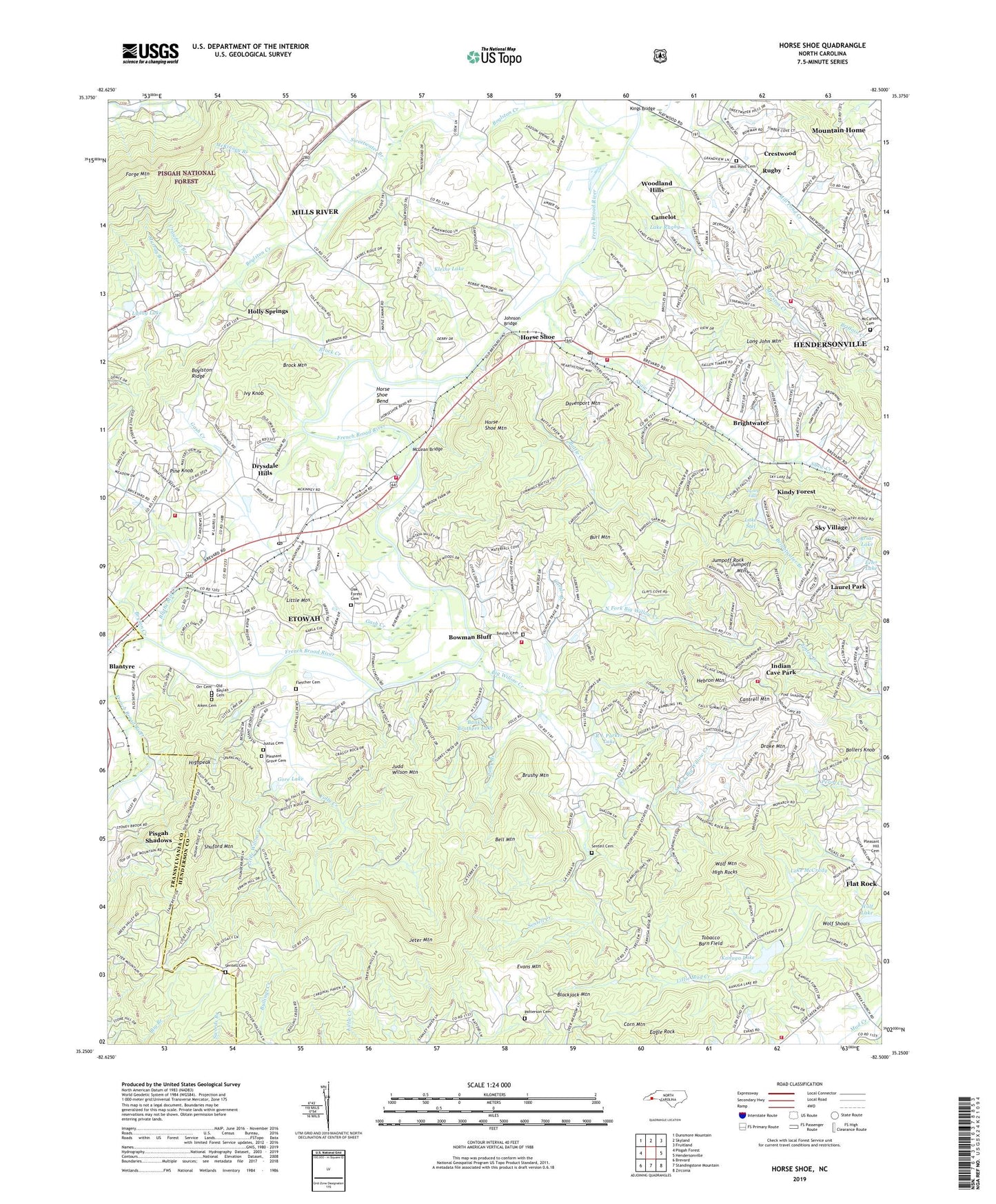
Horse Shoe North Carolina US Topo Map
Couldn't load pickup availability
Also explore the Horse Shoe Forest Service Topo of this same quad for updated USFS data
2023 topographic map quadrangle Horse Shoe in the state of North Carolina. Scale: 1:24000. Based on the newly updated USGS 7.5' US Topo map series, this map is in the following counties: Henderson, Transylvania. The map contains contour data, water features, and other items you are used to seeing on USGS maps, but also has updated roads and other features. This is the next generation of topographic maps. Printed on high-quality waterproof paper with UV fade-resistant inks.
Quads adjacent to this one:
West: Pisgah Forest
Northwest: Dunsmore Mountain
North: Skyland
Northeast: Fruitland
East: Hendersonville
Southeast: Zirconia
Southwest: Brevard
This map covers the same area as the classic USGS quad with code o35082c5.
Contains the following named places: Aiken Cemetery, Banks Brothers Lake, Banks Lake, Battle Creek, Bell Mountain, Beulah Baptist Church Cemetery, Beulah Church, Big Willow Creek, Blackjack Mountain, Blythe Mill Creek, Bollers Knob, Bowman Bluff, Boylston, Boylston Creek, Briar Lake, Briar Lake Dam, Brightwater, Brightwater Branch, Brightwater East, Brock Creek, Brock Mountain, Brushy Mountain, Bryson Creek, Burl Mountain, Camelot, Camp Ground Church, Camp Kanuga, Camp Osceola, Camp Tekoa, Cantrell Mountain, Carter Branch, Corn Mountain, Country Ridge, Crawford Branch, Crestwood, Cummings Memorial Church, Davenport Mountain, Drake Mountain, Drysdale Hills, Eagle Rock, Echo Lake, Echo Lake Dam, Etowah, Etowah Census Designated Place, Etowah Horse Shoe Volunteer Fire and Rescue Station 1, Etowah Horse Shoe Volunteer Fire and Rescue Station 2, Etowah Post Office, Etowah Shopping Center, Evans Mountain, Finlay Brook, Fleetwood Estates, Folly Creek, Forge Mountain, Forge Mountain Grist Mill Dam, Forge Valley Church, Foxwood, Fraizer Forest, French Broad Church, Gash Creek, Gore Lake, Green Acres, Hebron Mountain, High Rocks, Highpeak, Holly Springs, Horse Shoe, Horse Shoe Bend, Horse Shoe Census Designated Place, Horse Shoe Mountain, Horse Shoe Post Office, Hunter Crossing, Indian Cave Park, Indian Cove, Ivy Knob, Jeter Mountain, Johnson Bridge, Jones Gap Church, Judd Wilson Mountain, Jumpoff Mountain, Jump-Off Mountain Dam, Jump-Off Mountain Lake, Jumpoff Rock, Justus Cemetery, Kanuga Lake, Kanuga Lake Lower Dam, Kanuga Park, Kanuga Ridge, Kindy Forest, Kings Bridge, Kleine Lake, Lake McCrady, Lake Rugby, Lake Rugby Dam, Lake Stel, Little Mountain, Little Willow Creek, Lyday Lake, Maple Hill Church, Marston Creek, McCarson Cemetery, McKinney Branch, McLean Bridge, Mill Pond Cemetery, Mill Pond Creek, Mountain Home Census Designated Place, Mountain Home Fire and Rescue Department Station 3, Murray Branch, North Fork Big Willow Creek, Oak Forest Cemetery, Old Beulah Cemetery, Orr Cemetery, Patterson Cemetery, Pine Knob, Piney Branch, Pleasant Grove Baptist Church Cemetery, Pleasant Grove Church, Pleasant Hill Church, Quail Hollow, R L Parker Lake, Rugby, Rugby Junior High School, Sedgewood, Sentell Cemetery, Sentell Creek, Shaw Creek, Shaw Creek Church, Shuford Mountain, Silver Lake, Sky Lake Estates Dam, Sky Village, South Fork Big Willow Creek, State Prison Camp Number 124, Still Meadows, Sugar Hollow Farm, Sweetwater Branch, Sycamore, Thomas Fletcher Cemetery, Thomas Forest, Timbercreek, Tobacco Barn Field, Town of Laurel Park, Township of Crab Creek, Tree Haven, Turley Falls, Twin Brooks, Valley Hill Fire and Rescue Station 3, West Henderson High School, Westbridge, Westridge, Wildwood Heights, Willow Lake Dam, Willow Valley Lake Dam, Wolf Mountain, Wolf Shoals, Woodland Hills, Yale, ZIP Codes: 28729, 28739, 28766, 28791