
MyTopo
Monroe North Carolina US Topo Map
Couldn't load pickup availability
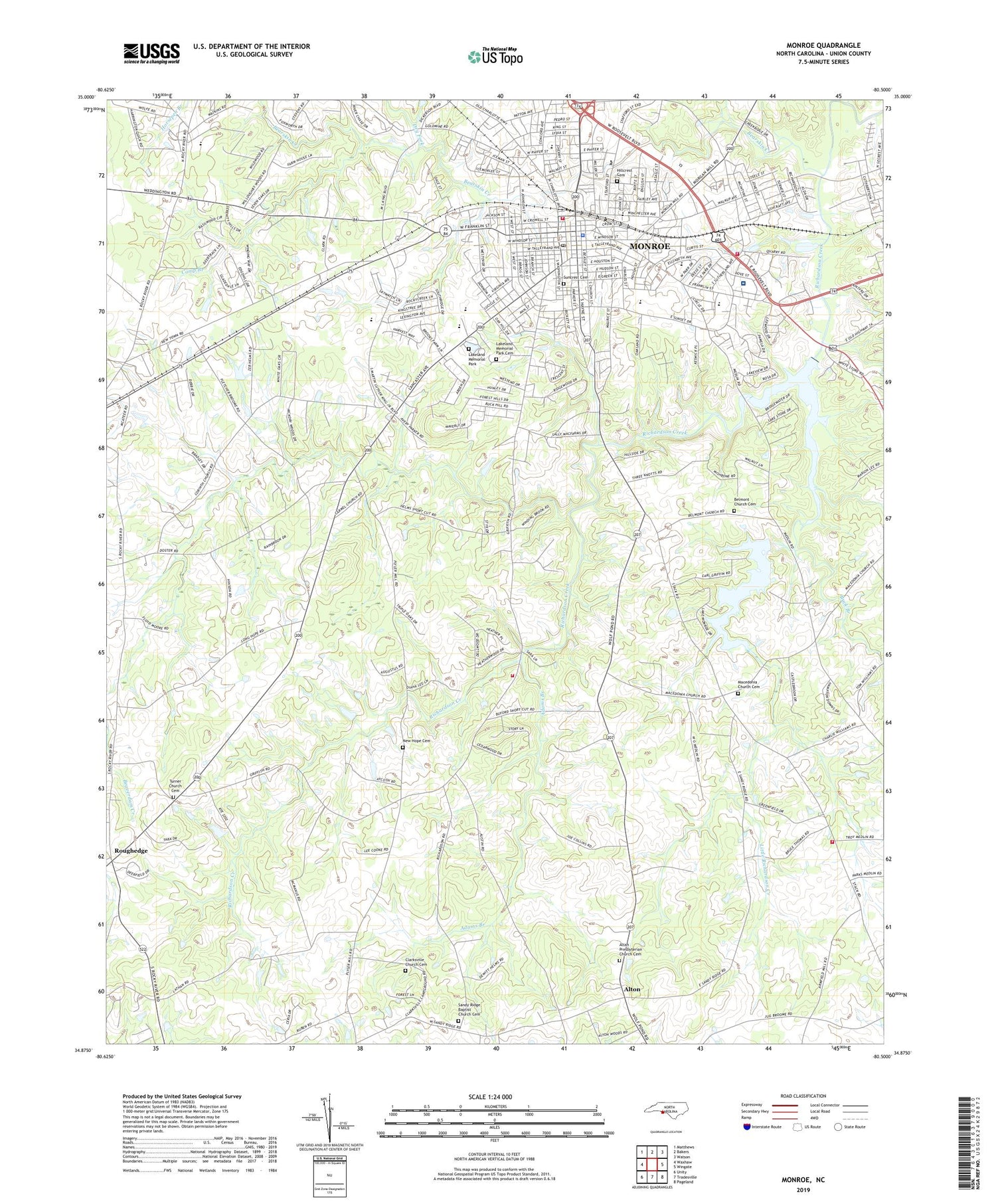
2019 topographic map quadrangle Monroe in the state of North Carolina. Scale: 1:24000. Based on the newly updated USGS 7.5' US Topo map series, this map is in the following counties: Union. The map contains contour data, water features, and other items you are used to seeing on USGS maps, but also has updated roads and other features. This is the next generation of topographic maps. Printed on high-quality waterproof paper with UV fade-resistant inks.
Quads adjacent to this one:
West: Waxhaw
Northwest: Matthews
North: Bakers
Northeast: Watson
East: Wingate
Southeast: Pageland
South: Tradesville
Southwest: Unity
Contains the following named places: Adams Branch, Altan Presbyterian Church Cemetery, Alton, Bearskin Creek, Beaverdam Creek, Belmont Church, Belmont Church Cemetery, Benton Heights, Benton Heights School, Boulevard Business Center, Bramblewood, Brookhaven, Buck Branch, Camp Branch, Carmel Village, Carolinas Healthcare System Union, Clarksville Church, Clarksville Church Cemetery, Corinth Church, Council Oaks, Creft Park, Dickerson Park, Dry Fork, East Elementary School, Forest Hills, Franklin Colony, Grace Church, Griffith Road Volunteer Fire Department Station 13, Guardian Care Convalescent Center, Heil Leah, Hillcrest, Hillcrest Cemetery, Jaycee Park, Keswick, Kingswood, Knollwood, Lake Lee, Lake Lee Dam, Lake Monroe, Lake Monroe Dam, Lakeland Memorial Park, Lakeland Memorial Park Cemetery, Lakeview Estates, Lee Wood, Liberty Church, Little Richardson Creek, Macedonia Church, Macedonia Church Cemetery, Monroe, Monroe Country Club and Golf Course, Monroe Fire Department Station 1, Monroe Fire Department Station 2, Monroe High School, Monroe Middle School, Monroe Plaza Shopping Center, Monroe Police Department, Monroe Post Office, Mount Carmel Church, New Hope Cemetery, New Hope Church, Northwood, Oakland, Park Place, Ridgewood, Rock Rest, Roland Park, Roughedge, Sandy Ridge Baptist Church Cemetery, Sandy Ridge Church, Sherwood Forest, Southgate Estates, Southwood Estates, Stack Road Volunteer Fire Department and Rescue Squad, Stewart Park, Suncrest Cemetery, Sunset Park, Sunset Plaza, Sutton Park, Sutton Park Church, Timber Lake, Township of Buford, Township of Monroe, Turner Church, Turner Church Cemetery, Union County, Union County Career Center, Union Emergency Medical Services, Union Village Shopping Center, Walter Bickett School, Walter Bickett Stadium, WDEX-AM (Monroe), Welsh Heights, White Oaks, Winchester Avenue Community Facility Center, WIXE-AM (Monroe), WMAP-AM (Monroe), ZIP Code: 28112


