MyTopo
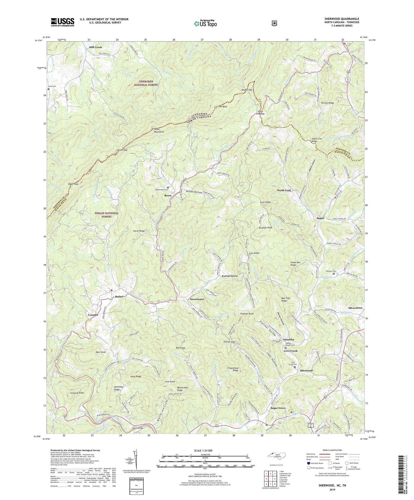
Sherwood North Carolina US Topo Map
Couldn't load pickup availability
2019 topographic map quadrangle Sherwood in the states of North Carolina, Tennessee. Scale: 1:24000. Based on the newly updated USGS 7.5' US Topo map series, this map is in the following counties: Watauga, Johnson. The map contains contour data, water features, and other items you are used to seeing on USGS maps, but also has updated roads and other features. This is the next generation of topographic maps. Printed on high-quality waterproof paper with UV fade-resistant inks.
Quads adjacent to this one:
West: Elk Mills
Northwest: Doe
North: Mountain City
Northeast: Baldwin Gap
Southeast: Boone
South: Valle Crucis
Southwest: Elk Park
Contains the following named places: Amantha, Baker Gap, Beaver Dam Volunteer Fire Department, Beaverdam Cemetery, Beaverdam Church, Beaverdam Creek, Beaverdam Ridge, Beaverdam School, Bee Tree Ridge, Bethel, Bethel Baptist Church, Bethel Elementary School, Brushy Fork, Buckeye Knob, Bulldog Creek, Buttermilk Branch, Center View, Center View Church, Center View School, Cornett Branch, Cove Creek Baptist Church, Cove Creek Cemetery, Cove Creek Census Designated Place, Cove Creek Elementary School, Cove Creek Volunteer Fire Department, Crossing Knob, Drake Branch, Dyer Knob, Eager Branch, East Fork Cove Creek, East Fork Furnace Creek, East Fork Furnance Creek, Egger Branch, Ellison Branch, Fletcher Hollow, Forest Grove, Forest Grove Baptist Church, Forest Grove Creek, Forest Grove School, Fork Branch, Fork Ridge, Frozenhead Ridge, George Gap, George Gap Branch, Glendale School, Greer Bridge, Greer Ford, Henson Chapel Cemetery, Henson Hollow, Hinsons Chapel Methodist Church, Hockiday Ridge, Horse Ridge, Isaac Hollow, Ivory Ridge, Ivory Ridge School, Jones Branch, Kirby Branch, Laurel Branch, Laurel Creek, Laurel Creek Falls, Leander, Little Beaverdam Creek, Little Zion Church, Locust Gap, Long Branch, Lost Ridge, Love Knob, Mabel, Mabel Elementary School, Mabel Methodist Church, Mast, Mill Creek, North Fork, North Fork Cove Creek, North Fork Ellison Branch, North Fork Sawyer Creek, North Fork School, Oak Grove School, Phillips Branch, Phillips School, Pine Grove School, Pleasant Cemetery, Prophet Knob, Reese, Rube Creek, Rush Branch, Rush Branch School, Sawyer Creek, Sharp Creek, Sherwood, Silverstone, Snake Den Ridge, South Fork Ellison Branch, State Line Gap, State Line Ridge, Sugar Grove, Sugar Grove Post Office, Sweetwater, Terman Ridge, The Bald, Township of Beaverdam, Township of Cove Creek, Trade Volunteer Fire Department, Union Baptist Church, Vanderpool Creek, Vaught Gap, Ward - Shull Cemetery, Ward Gap, Ward Hollow, Warren Hollow, Watauga Falls, West Fork Buttermilk Branch, West Fork Rube Creek, Willow Valley Baptist Church, Willowdale Church, Wilson Hill Mine, Wilson Hollow, Windy Gap School, Zion Hill Baptist Church, Zionville Volunteer Fire Department, ZIP Codes: 28679, 28692, 37691