MyTopo
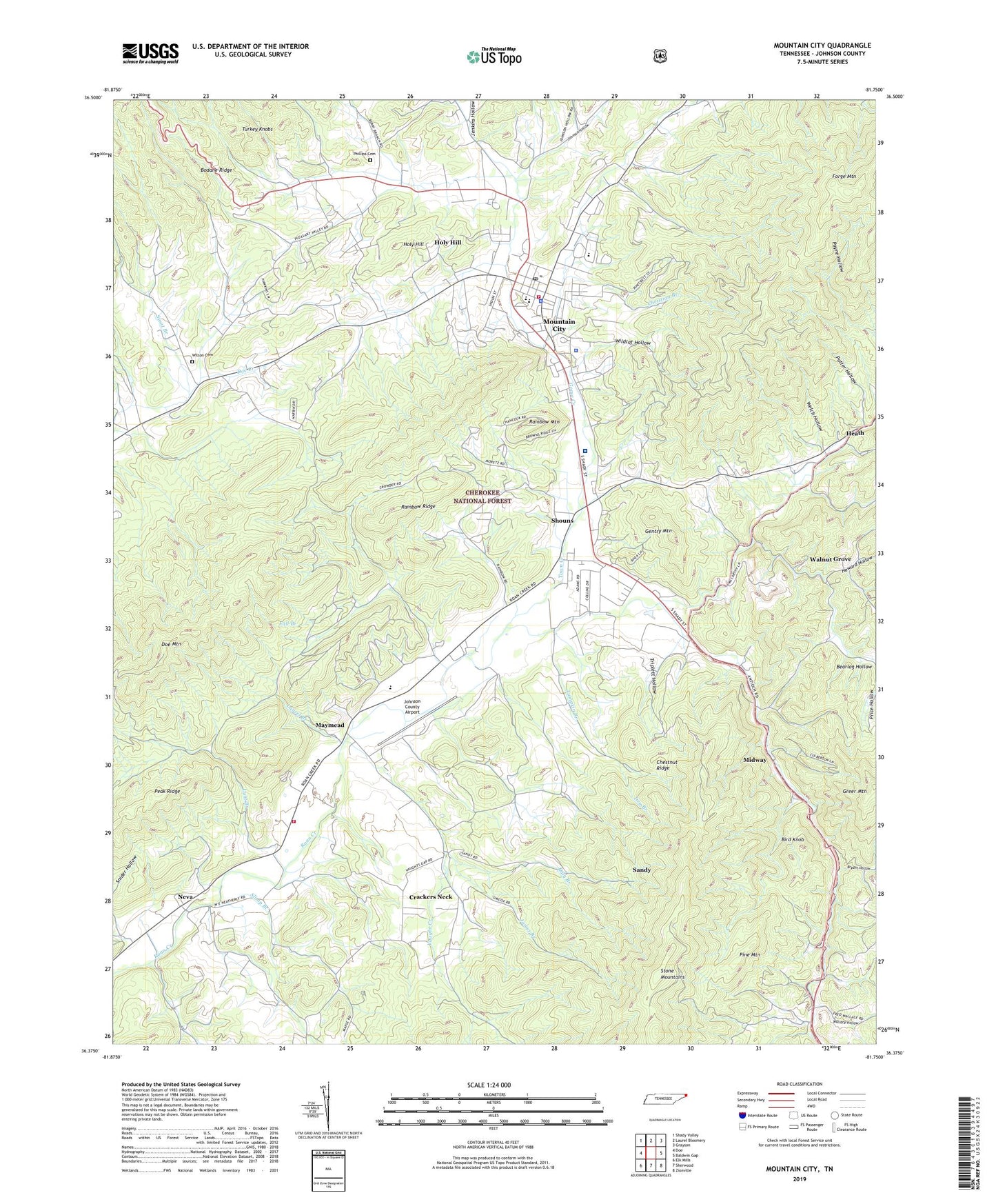
Mountain City Tennessee US Topo Map
Couldn't load pickup availability
Also explore the Mountain City Forest Service Topo of this same quad for updated USFS data
2022 topographic map quadrangle Mountain City in the state of Tennessee. Scale: 1:24000. Based on the newly updated USGS 7.5' US Topo map series, this map is in the following counties: Johnson. The map contains contour data, water features, and other items you are used to seeing on USGS maps, but also has updated roads and other features. This is the next generation of topographic maps. Printed on high-quality waterproof paper with UV fade-resistant inks.
Quads adjacent to this one:
West: Doe
Northwest: Shady Valley
North: Laurel Bloomery
Northeast: Grayson
East: Baldwin Gap
South: Sherwood
Southwest: Elk Mills
This map covers the same area as the classic USGS quad with code o36081d7.
Contains the following named places: Arnold Branch, Avery Branch, Bakers Gap, Barry Branch, Bee Cove Branch, Berea Church, Big Sandy Creek, Bird Knob, Bodane Ridge, Boomer Branch, Brownlow School, Brush Fork, Bryant Hollow, Butler Mine, Cabbage Creek, Cabbage Creek Prospect, Chestnut Ridge, Christian Branch, Cold Branch, Commissioner District 3, Commissioner District 7, Corn Creek, Crackers Neck, Cress Branch, Crooked Branch, Daniels Chapel School, Dewey School, Doe Mountain, Doughertys Forge, Dowell Quarry, Dry Branch, E H Phillippi Branch, Earls Chapel, East Fork Fall Branch, East Fork Laurel Branch, East Fork Lunt Branch, Evergreen Church, Fall Branch, Flint Knob Mine, Forge Creek, Forge Mountain, Furnace Creek, Gentry Mine, Gentry Mountain, Goose Creek, Greenwood School, Greer Mountain, Haskell Mine, Heath, Holy Hill, Howard Hollow, James Branch, James Branch Prospect, Jenkins Hollow, Johnson Chapel, Johnson County, Johnson County Airport, Johnson County Community Hospital, Johnson County Comprehensive Vocational School, Johnson County Emergency Medical Service and Rescue, Johnson County High School, Johnson County Middle School, Johnson County Sheriff's Department, Johnson Hollow, Katy Branch, Kettlefoot Lookout Tower, Key Station, Laurel Branch, Liberty Church, Little Mountain Mine, Lumpkin Branch, Lunt Branch, Mains Branch, Maymead, McEwen Branch, Midway, Mill Creek, Mount Vernon Church, Mountain City, Mountain City Division, Mountain City Elementary School, Mountain City Fire Department, Mountain City First Baptist Church, Mountain City Police Department, Mountain City Post Office, Muddy Branch, Neva, Neva Elementary School, Neva Volunteer Fire Department, Peak Ridge, Phillippi Cemetery, Phillips Prospect, Pine Grove Church, Pine Mountain, Pioneer Village Shopping Center, Pleasant Grove Baptist Church, Pleasant Valley School, Pleasant View Church, Potter Hollow, Rainbow Mountain, Rainbow Ridge, Rainbow School, Red Tail Mountain, Reese Branch, Reservoir Branch, Rhea Forge, Rhinestone Branch, Roan Creek Church, Roaring Creek, Sandy, Shaw Branch, Shouns, Shouns Chapel School, Shouns Elementary School, Shouns Prospect, Slimp Branch, Smith Branch, Snider Hollow, Steve Phillippi Branch, Stout Branch, Sweet Hollow, Town Creek, Town of Mountain City, Triplett Hollow, Turkey Knobs, Valley View Church, Vaught Branch, Vaught Creek, Vaughtsville, Vaughtsville Post Office, Wagner School, Wagners School, Wallace Branch, Wallace Hollow, Wallace School, Walnut Grove, Walnut Grove Baptist Church, Welch Hollow, West Fork Fall Branch, West Fork Laurel Branch, West Fork Lunt Branch, Wildcat Hollow, Wilson Cemetery, Wilson Prospect, WMCT-AM (Mountain City), Woods Hill Church, Woods School, Yellow HIll Mine, ZIP Code: 37683