MyTopo
Valle Crucis North Carolina US Topo Map
Couldn't load pickup availability
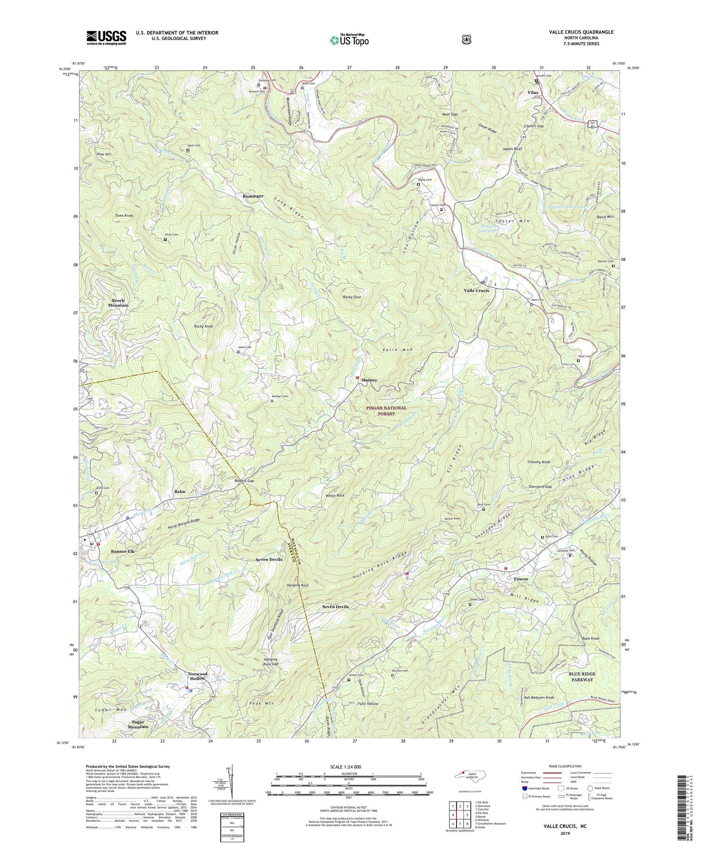
2019 topographic map quadrangle Valle Crucis in the state of North Carolina. Scale: 1:24000. Based on the newly updated USGS 7.5' US Topo map series, this map is in the following counties: Watauga, Avery. The map contains contour data, water features, and other items you are used to seeing on USGS maps, but also has updated roads and other features. This is the next generation of topographic maps. Printed on high-quality waterproof paper with UV fade-resistant inks.
Quads adjacent to this one:
West: Elk Park
Northwest: Elk Mills
North: Sherwood
East: Boone
Southeast: Globe
South: Grandfather Mountain
Southwest: Newland
Contains the following named places: Antioch Baptist Church, Antioch Cemetery, Antioch Church, Ash Bear Pen Dam, Ash Bearpen Knob, Baird Cemetery, Baird Creek, Bairds Creek Presbyterian Church, Balm, Banner Elk, Banner Elk Elementary School, Banner Elk Police Department, Banner Elk Post Office, Banner Elk Volunteer Fire and Rescue, Banner Elk Volunteer Fire Department Station 2, Bee Branch, Beech Mountain Church, Bethany Church, Big Branch, Big Ridge, Bowers Gap, Broadstone Lodge, Buck Knob, Byrd Cemetery, Calloway Cemetery, Church Cemetery, Clark Creek, Clarks Creek Baptist Church, Cool Spring School, Council Gap, Cove Creek, Craborchard Creek, Danner Cemetery, Dark Hollow, Devils Lake Dam, Different Drum Dam, Different Drum Lake, Dutch Creek, Dutch Creek Falls, Dutch Creek School, Elk Ridge, Falls Hollow, Farthing Cemetery, Flattop Creek, Foscoe, Foscoe Census Designated Place, Foscoe Volunteer Fire Department, Four Diamond Ridge, Grace Hartley Memorial Hospital, Green Ridge Branch, Gwyn Ridge, Hanging Rock, Hanging Rock Chapel, Hanging Rock Creek, Hanging Rock Gap, Hanging Rock Golf and Country Club, Hanging Rock Ridge, Hayes Bluff, Hicks Cemetery, Holy Communion Lutheran Church, Holy Cross Episcopal Church, Horse Bottom Creek, Horse Bottom Ridge, Howell Cemetery, Jestes Cemetery, Johnson School, Liberty Methodist Church, Linville Creek, Long Ridge, Lost Branch, Lou Hollow, Mast Cemetery, Mast Farm Inn, Mast Gap, Mast General Store, Matney, McLean Cemetery, Michael Cemetery, Mill Pond, Mill Ridge, Moody Mill Creek, Mount Calvary Church, Nettle Knob, Norwood Hollow, Oliver Hollow, Peak Mountain, Pigeonroost Creek, Pine Hill, Pine Ridge, Piney Grove Methodist Church, Ponds of the Beech, Potts Cemetery, Rocky Face, Rocky Knob, Rominger, Rominger School, Rosasco Dam Upper, Rosasco Lake Upper, Saint Anthony Church, Saint Johns Episcopal Church, Sawmill Branch, Seven Devils, Seven Devils Fire Department, Seven Devils Police Department, Shanty Spring Branch, Shawneehaw Creek, Shawneehaw Volunteer Fire Department, Shook Cemetery, Shull Cemetery, Snakeden Ridge, Spice Bottom Creek, Spice Branch, Sugar Creek, Sugar Mountain, Sugar Mountain Police Department, Tester Mountain, Timothy Knob, Toms Knob, Town of Banner Elk, Town of Seven Devils, Townsend Gap, Township of Laurel Creek, Township of Shawneehaw, Township of Watauga, Valle Crucis, Valle Crucis Census Designated Place, Valle Crucis Elementary School, Valle Crucis Methodist Church, Valle Crucis Mission, Valle Crucis Post Office, Valle Crucis School, Valle Mountain, Valley Creek, Vilas, Vilas Post Office, Village of Sugar Mountain, Ward Cemetery, Watauga Baptist Church, Watauga School, White Rock, White Rock Baptist Church, Whiting School, Worley Creek, Yates Cemetery, Young Hollow, ZIP Code: 28604