MyTopo
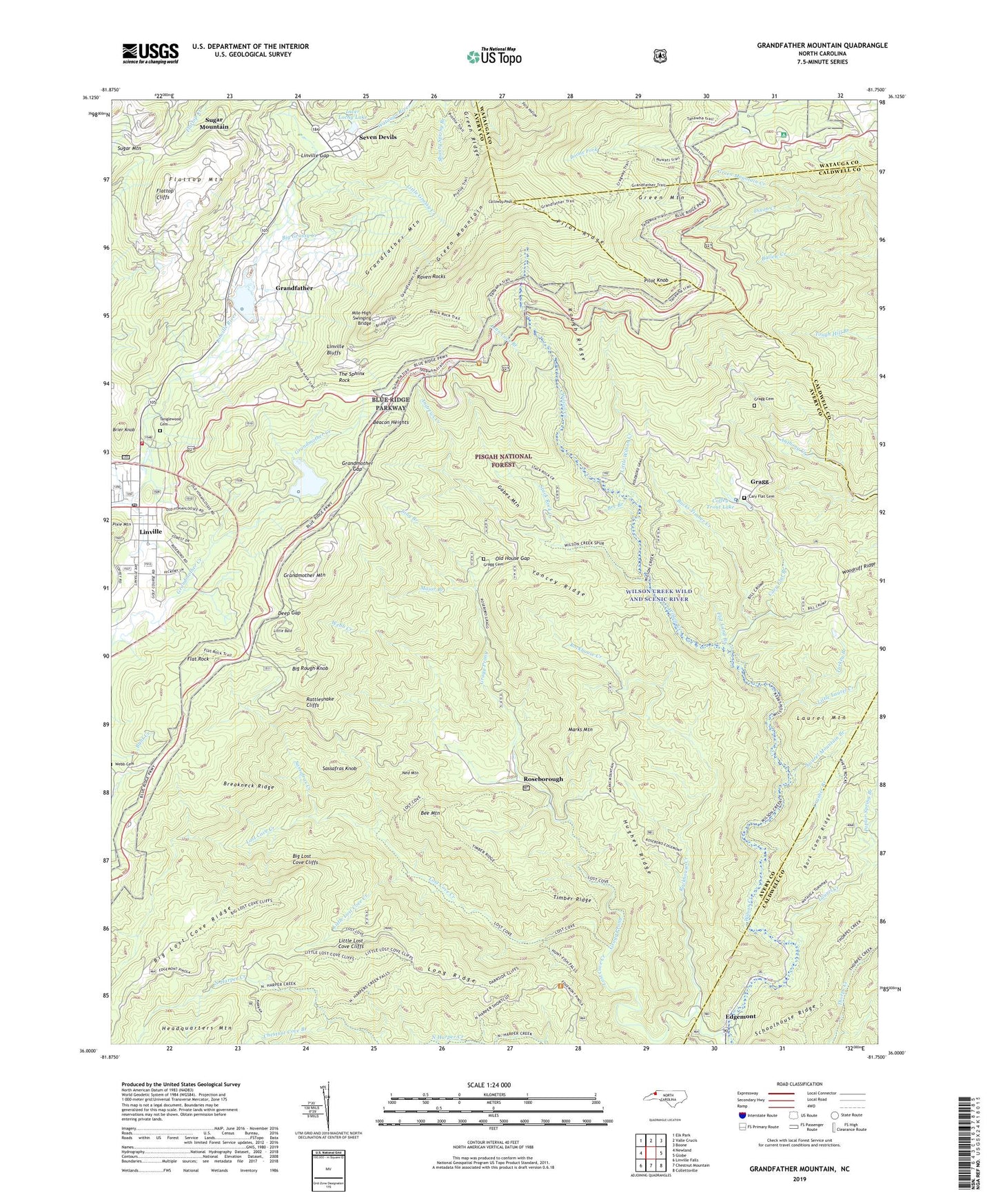
Grandfather Mountain North Carolina US Topo Map
Couldn't load pickup availability
Also explore the Grandfather Mountain Forest Service Topo of this same quad for updated USFS data
2022 topographic map quadrangle Grandfather Mountain in the state of North Carolina. Scale: 1:24000. Based on the newly updated USGS 7.5' US Topo map series, this map is in the following counties: Avery, Caldwell, Watauga. The map contains contour data, water features, and other items you are used to seeing on USGS maps, but also has updated roads and other features. This is the next generation of topographic maps. Printed on high-quality waterproof paper with UV fade-resistant inks.
Quads adjacent to this one:
West: Newland
Northwest: Elk Park
North: Valle Crucis
Northeast: Boone
East: Globe
Southeast: Collettsville
South: Chestnut Mountain
Southwest: Linville Falls
This map covers the same area as the classic USGS quad with code o36081a7.
Contains the following named places: Andrews Creek, Appalachian Camp, Bark Camp Ridge, Beacon Heights, Bee Branch, Bee Mountain, Big Grassy Creek, Big Lost Cove Cliffs, Big Lost Cove Ridge, Big Rough Knob, Breakneck Ridge, Brier Knob, Bucks Timber Creek, Calloway Peak, Cary Flat Branch, Cary Flat Cemetery, Cherokee Woods, Chestnut Cove Branch, Coffey Trout Lake, Crusher Branch, Daniel Boone Scout Trail, Deep Gap, Edgemont, Edgemont Baptist Church, Flat Land Branch, Flat Rock, Flattop Cliffs, Flattop Mountain, Gabes Mountain, Gragg, Gragg Cemetery, Gragg Prong, Grandfather, Grandfather Mountain, Grandfather Mountain Lake, Grandfather Mountain Lake Lake Dam, Grandmother Dam, Grandmother Gap, Grandmother Lake, Grandmother Mountain, Green Mountain, Green Mountain Creek, Green Ridge, Hemlock Ridge, Hopkins Chapel, Hughes Ridge, Inver Lochy Dam, Inver Lochy Lake, Laurel Creek, Laurel Mountain, Laurel Mountain Branch, Ling Branch, Linn Cove Branch, Linville, Linville Bluffs, Linville Census Designated Place, Linville Gap, Linville Post Office, Linville Volunteer Fire Department, Little Bald, Little Grassy Creek, Little Laurel Creek, Little Lost Cove Cliffs, Little Lost Cove Creek, Little Wilson Creek, Long Ridge, Lost Cove Creek, Major Branch, Marks Mountain, Mile High Swinging Bridge, Ned Mountain, New Hopewell Church, North Harper Creek, Old House Gap, Peoples Church, Pilot Knob, Pilot Ridge, Poplar Spring Branch, Rattlesnake Cliffs, Raven Rocks, Rockhouse Creek, Roseborough, Rough Ridge, Sassafras Creek, Sassafras Knob, Stack Rock Creek, Tanglewood Cemetery, The Sphinx Rock, Timber Ridge, Township of Carey's Flat, Township of Linville, Turkey Branch, United States Weather Station, Village of Grandfather Village, Webb Creek, West Fork Linville River, Wilsons Creek Township, Woodruff Ridge, WUNE-TV (Linville), Yancey Ridge, Yancey Ridge Trail, ZIP Code: 28646