
MyTopo
Minot North Dakota US Topo Map
Couldn't load pickup availability
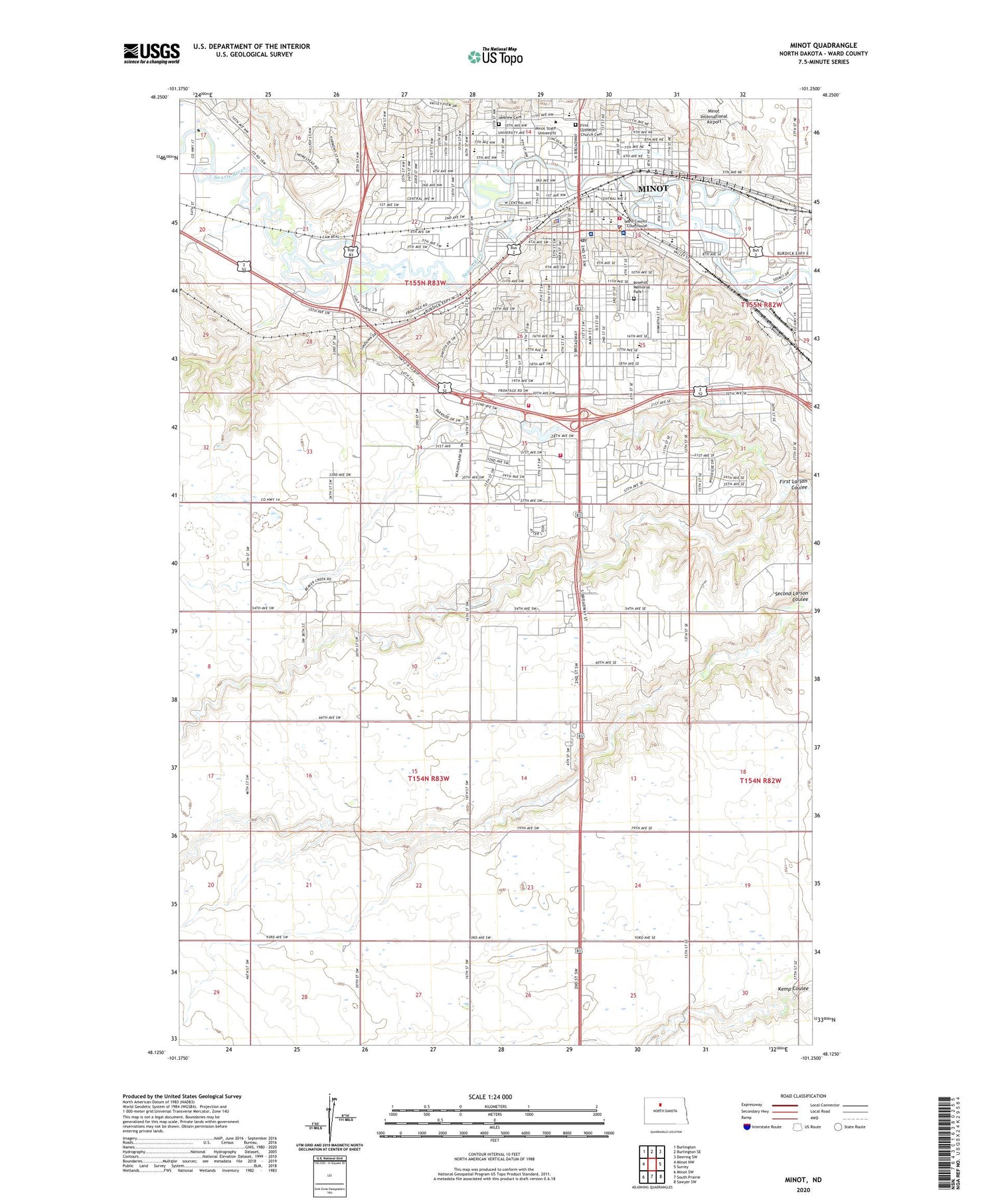
2020 topographic map quadrangle Minot in the state of North Dakota. Scale: 1:24000. Based on the newly updated USGS 7.5' US Topo map series, this map is in the following counties: Ward. The map contains contour data, water features, and other items you are used to seeing on USGS maps, but also has updated roads and other features. This is the next generation of topographic maps. Printed on high-quality waterproof paper with UV fade-resistant inks.
Quads adjacent to this one:
West: Minot NW
Northwest: Burlington
North: Burlington SE
Northeast: Deering SW
East: Surrey
Southeast: Sawyer SW
South: South Prairie
Southwest: Minot SW
Contains the following named places: A L Cameron Medical Library, Administration Building, Aleshire Theater, All Saints Episcopal Church, Ann Nicole Nelson Hall, Arrowhead Shopping Center, Augustana Lutheran Church, Beaver Lodges, Beaver Suites, Bel Air Elementary School, Berean Baptist Church, Bethany Lutheran Church, Bible Fellowship Church, Bishop Ryan Catholic School, Bread of Life Lutheran Church, Bruce M Van Sickle United States Courthouse, Central Campus School, Christ Lutheran Church, City of Minot, Community Ambulance Service of Minot, Cook Hall, Corbett Field, Crane Hall, Cyril Moore Science Center, Dakota Bark Park, Dakota Hall, Dakota Square, Edison Elementary School, Facilities Management Building, Faith United Methodist Church, First Baptist Church, First Lutheran Church, First Lutheran Church Cemetery, Gordon B Olson Library, Hartnett Hall, Hebrew Cemetery, Herbert M Parker Stadium, Jack Hoeven Park, Jack Hoeven Wee Links, Jim Hill Middle School, John Moses Memorial Hospital, KCJB-AM (Minot), KIZZ-FM (Minot), KMOT-TV (Minot), KTYN-AM (Minot), Leach Park, Lillian and Coleman Taube Museum of Art, Lincoln Elementary School, Little Flower Catholic Church, Little Flower School, Livingston Creek, Longfellow Elementary School, Lucy's Amusement Park, Lura Manor, Magic City Campus High School, Magic City International Dragway, Manor Care Health Services, Maysa Arena, McCulloch Hall, McKinley Elementary School, Memorial Hall, Minot, Minot Adult Learning Center, Minot City Hall, Minot Fire Station 1, Minot Fire Station 2, Minot Plaza, Minot Police Department, Minot Post Office, Minot Public Library, Minot Rural Fire Department, Minot State University, Minot State University Dome, Minot State University Student Center, Minot State University Wellness Center, Minot Water Supply Dam, Model Hall, Motor Pool Building, Nodak Speedway, North Dakota Highway Patrol Minot, North Dakota State Fair Center, Northwest Bible College, Oak Park, Oak Park Shopping Center, Old Main Building, Old Soo Depot Transportation Museum and Western History Research Center, Our Redeemer's Christian School, Perkett Elementary School, Pioneer Hall, Railroad Museum of Minot, Roosevelt Elementary School, Roosevelt Park, Roosevelt Park Zoo, Rosehill Memorial Park, Saint John the Apostle Catholic Church, Saint Leo's Catholic Church, Saint Mark's Lutheran Church, Saint Michael's Catholic Church, Scandinavian Heritage Park, Souris River Campus Alternative High School, Souris Valley Golf Course, South Hill Complex, Sunnyside Elementary School, Swain Hall, Town and Country Shopping Center, Township of Afton, Township of Harrison, Trinity Homes Nursing Home, Trinity Hospital, Trinity Hospital - St. Joseph's, Trinity Medical Center Helipad, Ward County Courthouse, Ward County Historical Society Museum and Pioneer Village, Ward County Jail, Ward County Public Library, Ward County Sheriff's Office, Washington Elementary School, ZIP Codes: 58701, 58702, 58707


