MyTopo
Friendship Ohio US Topo Map
Couldn't load pickup availability
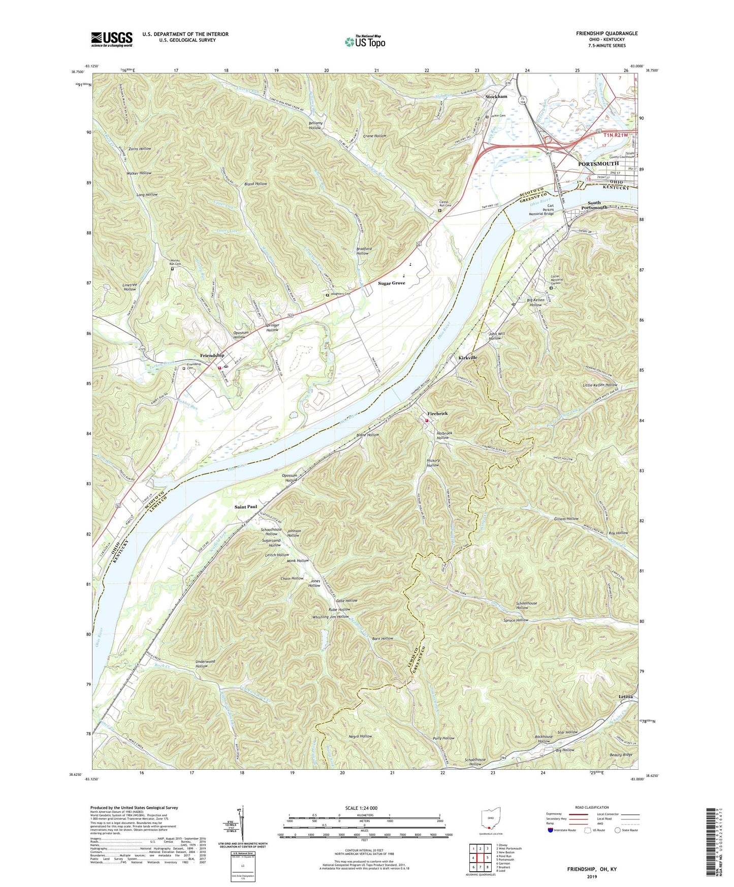
2019 topographic map quadrangle Friendship in the states of Kentucky, Ohio. Scale: 1:24000. Based on the newly updated USGS 7.5' US Topo map series, this map is in the following counties: Scioto, Lewis, Greenup. The map contains contour data, water features, and other items you are used to seeing on USGS maps, but also has updated roads and other features. This is the next generation of topographic maps. Printed on high-quality waterproof paper with UV fade-resistant inks.
Quads adjacent to this one:
West: Pond Run
Northwest: Otway
North: West Portsmouth
Northeast: New Boston
East: Portsmouth
Southeast: Load
South: Brushart
Southwest: Garrison
Contains the following named places: Alexandria, Alexandria Post Office, All Saints Episcopal Church, Barn Hollow, Bellamy Hollow, Bellamy Run, Bethel Church, Big Hollow, Big Kellen Hollow, Bland Hollow, Blane Hollow, Bradford Hollow, Bronze Run, Brouse Run, Carey Run School, Careys Run, Careys Run Cemetery, Careys Run Church, Carl Perkins Memorial Bridge, Chain Hollow, Collier Memorial Garden, Crane Hollow, Dennis, Dennis Post Office, Earl Thomas Conley Riverside Park, Fire Brick Volunteer Fire Department, Firebrick, Firebrick Post Office, Firebrick Railroad Station, Firebrick Volunteer Fire Department, First Presbyterian Church, Friendship, Friendship Cemetery, Friendship Census Designated Place, Friendship Elementary School, Friendship Post Office, G N Cabin Railroad Station, Gate Hollow, Gillem Hollow, Glen Railroad Station, Hickory Hollow, Holbrook Hollow, Hygean Run, Indian Run, Infirmary Landing, John Will Hollow, Johnson Hollow, Jones Hollow, Kentucky Heights Church, Kirkville, Larkin Cemetery, Left Fork Rock Creek, Leitch Hollow, Letitia, Linetree Hollow, Little Kellen Hollow, Lock and Dam Number 31, Long Hollow, Lousy Run, Lower Lick, Manuel Moores Landing, Monk Hollow, Nace Run, Nile Township Fire Department, Odell Creek, Opossum Hollow, Pancoast Landing, Polly Hollow, Pond Run, Portsmouth Bar and Law Library, Portsmouth Wesleyan Church, Rabbit Run, Right Fork Rock Creek, Riverfront Park, Rock Creek, Rock Creek Landing, Rockhouse Hollow, Roy Hollow, Rube Hollow, Saint Marys Catholic Church, Saint Marys School, Saint Paul, Saint Paul Methodist Church, Saint Pauls Christian Church, Saint Pauls Landing, Saint Pauls Post Office, Scaffold Lick, Schoolhouse Hollow, Scioto Ambulance District Squad 1, Scioto County Courthouse, Scioto County Home, Scioto River, Scudder Center School, Second Street Historic District, Shannoah Town, Shawnee Airport, Shawnee State Park Marina, Sixth Street Historic District, Slab Run, Slab Run Church, South Portsmouth, South Portsmouth Post Office, South Portsmouth School, Spellacy Run, Springer Hollow, Spruce Hollow, Star Hollow, Stockham, Stony Run, Stony Run Church, Stony Run Tabernacle, Sugar Grove, Sugarcamp Hollow, Sullivans Landing, Sulphur Lick, Township of Washington, Turkey Creek, Underwood Hollow, Upper Lick, Vaughters Cemetery, Vaughters Run, Walker Hollow, Walker Landing, Whistling Jim Hollow, White Oak Chapel, Worley Run, Worley Run Cemetery, Zorns Hollow, ZIP Codes: 41166, 41174, 45630, 45663