MyTopo
Kenton Ohio US Topo Map
Couldn't load pickup availability
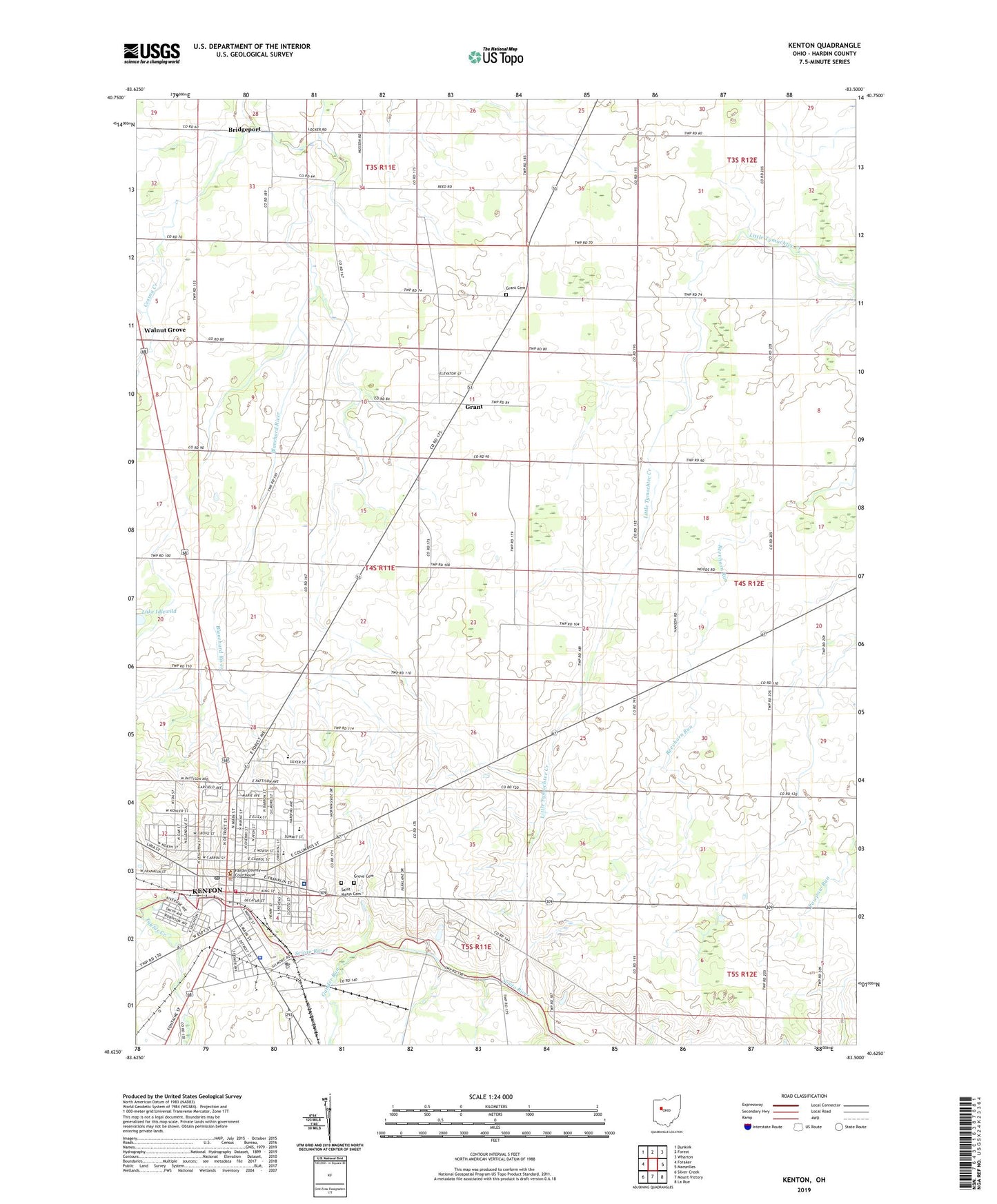
2019 topographic map quadrangle Kenton in the state of Ohio. Scale: 1:24000. Based on the newly updated USGS 7.5' US Topo map series, this map is in the following counties: Hardin. The map contains contour data, water features, and other items you are used to seeing on USGS maps, but also has updated roads and other features. This is the next generation of topographic maps. Printed on high-quality waterproof paper with UV fade-resistant inks.
Quads adjacent to this one:
West: Foraker
Northwest: Dunkirk
North: Forest
Northeast: Wharton
East: Marseilles
Southeast: La Rue
South: Mount Victory
Southwest: Silver Creek
Contains the following named places: Ark of the Covenant Church, Bridgeport, Buck - Pleasant - Kenton Ambulance District, C E Wharton Memorial Park, Calvary Baptist Church, Calvary Tabernacle, Central Church of Christ, Central School, Cessna Creek, Church of the Nazarene, City of Kenton, Community Christian Fellowship Church, Cornerstone Christian Fellowship Church, Deeper Life Church of Christ, Eastcrest Elementary School, Eleventh Hour Tabernacle United Pentecostal Church, Ellis Junior High School, Epworth United Methodist Church, Espy Elementary School, Eureka Church, Eureka School, Fairview School, First Baptist Church, First Christian Church, First Church of God, First Presbyterian Church, First Reformed United Church of Christ, First United Methodist Church, Foursquare Gospel Church, Gander Run, Grant, Grant Cemetery, Grant Post Office, Greenleaf School, Greenwood School, Grove Cemetery, Hardin Central Elementary School, Hardin County Courthouse, Hardin County Fairgrounds, Hardin County Jail, Hardin County Library, Hardin County Sheriff's Office, Hardin Memorial Hospital, Hardin Memorial Hospital Heliport, Henpeck School, Hi-Road Drive-In, House of Prayer Pentecostal Church of God, Immaculate Conception Church, Kenton, Kenton Baptist Temple, Kenton Church, Kenton Courthouse Square Historic District, Kenton Fire Department, Kenton High School, Kenton Municipal Building, Kenton Police Department, Kenton Post Office, Kenton Shopping Plaza, Manlove Run, Miller School, North Main-North Detroit Street Historic District, North School, Northwood Elementary School, Oaklief Elementary School, Our Saviors Lutheran Church, Payne Chapel African Methodist Episcopal Church, Pioneer Park, Robinson Field, Rush Mobile Home Park, Saint Anthonys School, Saint Johns United Church of Christ, Saint Marys Cemetery, Salem Church, San Antonio Hospital, Silver Creek, Sixtyeight Trailer Park, Sycamore School, Taylor Creek, Township of Pleasant, Trinity United Presbyterian Church, Veterans Memorial Park, Walnut Grove, Wesleyan Methodist Church, Westview Elementary School, Westview Estates, WKTN-FM (Kenton), ZIP Code: 43326