MyTopo
Orrville Ohio US Topo Map
Couldn't load pickup availability
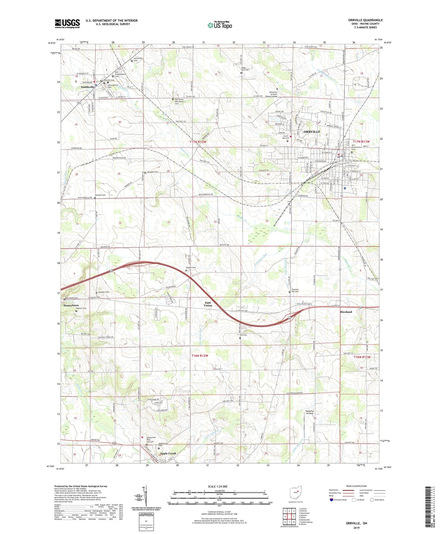
2019 topographic map quadrangle Orrville in the state of Ohio. Scale: 1:24000. Based on the newly updated USGS 7.5' US Topo map series, this map is in the following counties: Wayne. The map contains contour data, water features, and other items you are used to seeing on USGS maps, but also has updated roads and other features. This is the next generation of topographic maps. Printed on high-quality waterproof paper with UV fade-resistant inks.
Quads adjacent to this one:
West: Wooster
Northwest: Creston
North: Rittman
Northeast: Doylestown
East: Dalton
Southeast: Wilmot
South: Fredericksburg
Southwest: Holmesville
Contains the following named places: Anderson School, Apple Creek, Apple Creek Developmental Center, Apple Creek Elementary School, Apple Creek Volunteer Fire Department, Applecreek Cemetery, Applecreek West End Cemetery, Arlo Acres, Auble Emergency Medical Services and Ambulance, Auburn Estates, Aultman Orrville Hospital, Besancon Farm, Blatter Airport, Bodine Cemetery, Buehlers Shopping Center, Cedar Lane Farms, Central Fire District Station 1 Headquarters, City of Orrville, Crosskeys Run, Crown Hill Cemetery, East Union, East Union Cemetery, East Union Church, Edinburgh, Edinburgh Mill, Erb Cemetery, First Church of God, Five Points, Fountain Hill Cemetery, Four T Mobile Home Park, Gailey Park, Glen Ridge Mobile Home Park, Greene Middle School, Hodge Farms, Kapp - Gish Cemetery, Kohler Farms, Leopold Farms, Little Chippewa Estates, Little Sugar Creek, Maple Grove School, Maple Street Elementary School, Millbourne Mobile Manor, Morningstar Baptist Church, North Elementary School, Oak Grove Mennonite Cemetery, Oak Grove Mennonite Church, Oak Street Elementary School, Old Hill Cemetery, Old Lutheran Cemetery, Old Presbyterian Cemetery, Orr Park, Orrs Community Cemetery, Orrville, Orrville Baptist Church, Orrville City Hall, Orrville Fire Department Station 1, Orrville Fire Department Station 2, Orrville High School, Orrville Middle School, Orrville Police Department, Orrville Post Office, Orrville Public Library, Orrville Trailer Park, Orrville Water Treatment Plant, Paradise, Paradise Cemetery, Paradise Church of the Brethren, Riceland, Riceland Golf Course, Rohr Farm, Saint Agnes Catholic Church, Saint Agnes School, Saint Lukes Methodist Church, Saint Pauls Lutheran Church, Samaritan Care Ambulance, Schmidt Community Center, Schmucker Farms, School Number 1, School Number 3, School Number 4, Schott Farms, Shoup Farm, Smithville, Smithville Cemetery, Smithville Church of the Brethren, Smithville Elementary School, Smithville High School, Smithville Police Department, Smithville Post Office, Smithville United Methodist Church, Smithville Water Treatment Plant, Sommer Cemetery, Stauffer Cemetery, Stoltzfus Airfield, The United Church, Township of East Union, Township of Green, Triple H Farm, Village of Smithville, Wayne General Hospital, Weaver Cemetery, Weilersville, Whispering Pines Estates, Wooster Rolling Wheels, ZIP Codes: 44667, 44677