MyTopo
Piqua East Ohio US Topo Map
Couldn't load pickup availability
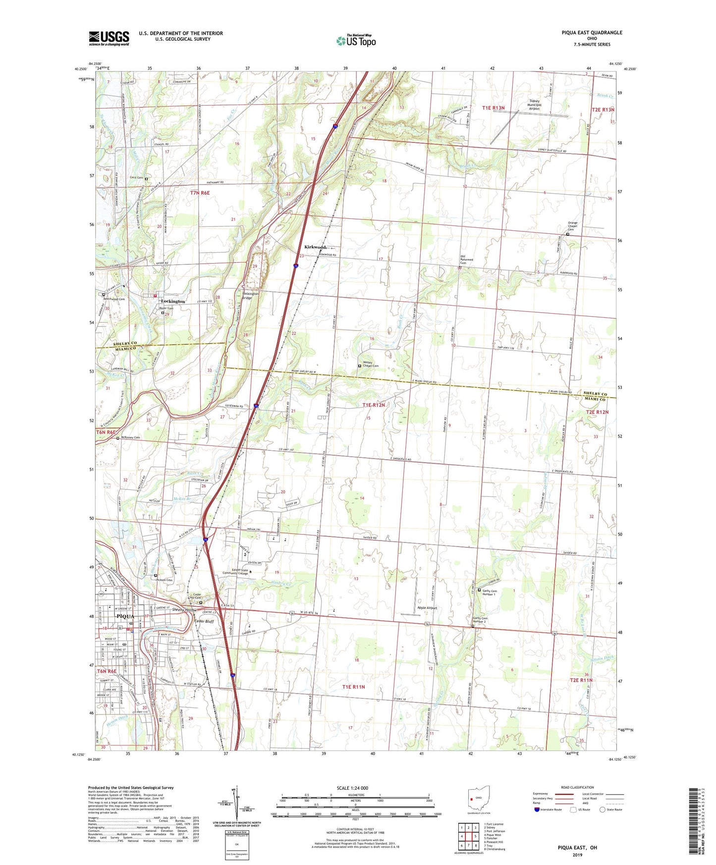
2019 topographic map quadrangle Piqua East in the state of Ohio. Scale: 1:24000. Based on the newly updated USGS 7.5' US Topo map series, this map is in the following counties: Miami, Shelby. The map contains contour data, water features, and other items you are used to seeing on USGS maps, but also has updated roads and other features. This is the next generation of topographic maps. Printed on high-quality waterproof paper with UV fade-resistant inks.
Quads adjacent to this one:
West: Piqua West
Northwest: Fort Loramie
North: Sidney
Northeast: Port Jefferson
East: Fletcher
Southeast: Christiansburg
South: Troy
Southwest: Pleasant Hill
Contains the following named places: Apostolic Gospel Temple, Apple Airport, Beechwood Cemetery, Bennett Junior High School, Brush Creek, Cecil Cemetery, Cedar Bluff, Cedar Hill Cemetery, Central Baptist Church, Central High School, Church of Jesus, City of Piqua, Community Missionary Church, Congregational Christian Church, Cyrene African Methodist Episcopal Church, Dershem Farms, Edison State College, Ely Farms, Evangelical United Methodist Church, First United Church of Christ, Flesh Public Library, Fox Creek, Frogpond School, Garbry Big Woods Reserve, Garbry Big Woods Sanctuary, Garbry Creek, Garbry School, Garby Cemetery 2, Garby Cemetery Number 1, Good Shepherd Presbyterian Church, Grace United Methodist Church, Greene Street United Methodist Church, Hickory Dell Estates, Hill Farms, Interstate 75 Industrial Park, Jackson Cemetery, Johnston Prairie, K E Farms, Kirkwood, Kirkwood Post Office, Liberty Baptist Church, Lockington, Lockington Bridge, Lockington Dam, Lockington Locks, Lockington Locks Historical Area, Lockington Post Office, Lockington Reserve, Lockington Reservoir, Lockington Volunteer Fire Department, Loramie Creek, Loramie Mill, McKee Branch, McKee Creek, McKinney Cemetery, Miami Erie Canal, Miami Valley Centre Shopping Center, Miami Valley Floral Farm, Mill Branch, Mill Creek, Mote Park, New Life Fellowship Church, Nicklin Avenue Elementary School, Ohio State Highway Patrol - Piqua Patrol Post, Old Reformed Cemetery, Orange Chapel, Orange Chapel Cemetery, Park Avenue Baptist Church, Piqua, Piqua City Hall, Piqua East Mall Shopping Center, Piqua Fire Department, Piqua High School, Piqua Industrial Park, Piqua Low Head Dam, Piqua Low Head Reservoir, Piqua Memorial Medical Center, Piqua Police Department, Piqua Post Office, Piqua Power Plant, Piqua Temple of Seekers of Light, Piqua-Caldwell Historic District, Razer Cemetery, Redinbo Farm, Roosevelt Park, Rossville, Rush Creek, Saint Boniface Catholic Church, Saint Bonifaces School, Saint James Episcopal Church, Saint Johns Lutheran Church, Saint Marys Catholic Church, Saint Marys School, Saint Pauls United Church of Christ, Scarborough Industrial Park, School Number 2, Shawnee Creek, Sheeny Hollow, Sheepskin School, Shelby County Home, Sidney Municipal Airport, Simmons School, Snodgrass School, South Street Elementary School, Spring Creek Church, Spring Creek Pit, Spring Creek Quarry, Spring Street School, Springcreek Elementary School, Staunton Street School, Temple Anshe Emeth, Township of Orange, Township of Springcreek, Upper Valley Joint Vocational School, Village of Lockington, Wesley Chapel Cemetery, West Branch Lost Creek, Westminster United Presbyterian Church, Whitackers Court, ZIP Code: 45356