
MyTopo
Bartlesville North Oklahoma US Topo Map
Couldn't load pickup availability
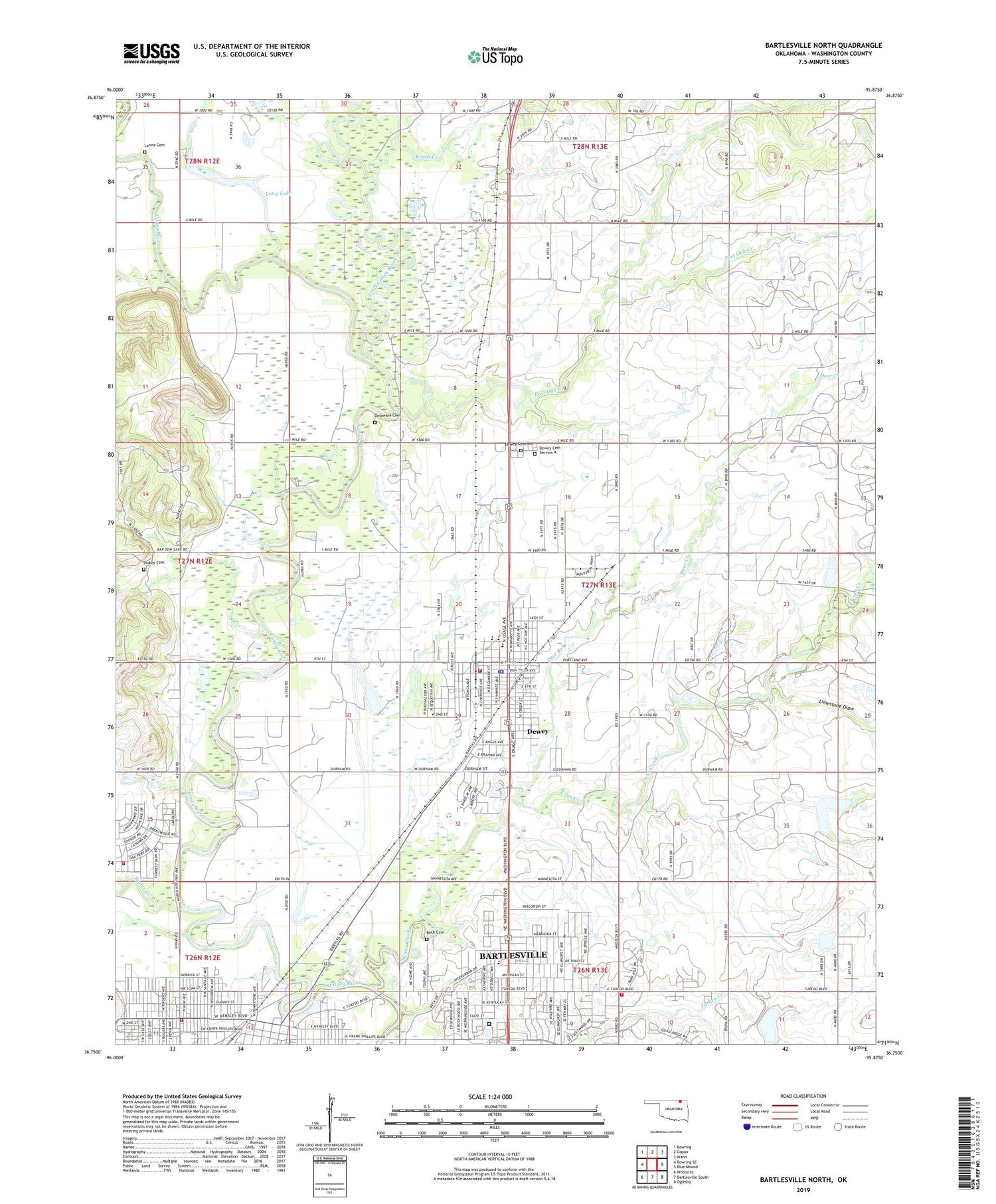
2019 topographic map quadrangle Bartlesville North in the state of Oklahoma. Scale: 1:24000. Based on the newly updated USGS 7.5' US Topo map series, this map is in the following counties: Washington. The map contains contour data, water features, and other items you are used to seeing on USGS maps, but also has updated roads and other features. This is the next generation of topographic maps. Printed on high-quality waterproof paper with UV fade-resistant inks.
Quads adjacent to this one:
West: Bowring SE
Northwest: Bowring
North: Copan
Northeast: Wann
East: Blue Mound
Southeast: Oglesby
South: Bartlesville South
Southwest: Woolaroc
Contains the following named places: Adams Municipal Golf Course, Antioch Church, Baptist First Church - Dewey, Baptist Temple, Bartlesville Division, Bartlesville Fire Department Station 2, Bartlesville Fire Department Station 3, Bartlesville Hospital Continuous Care Center, Beck Cemetery, Bible Church of Bartlesville, Bluestem Baptist Church, Bluestem School, Brush Creek, Butler Creek, Church of Christ, City of Dewey, Coon Creek, Cotton-Coon-Mission Creek Site 13 Dam, Cotton-Coon-Mission Creek Site 13 Reservoir, Cotton-Coon-Mission Creek Site 15 Dam, Cotton-Coon-Mission Creek Site 15 Reservoir, Deer Creek, Delaware Cemetery, Dewey, Dewey Cemetery, Dewey Cemetery Section 4, Dewey Church of the Nazarene, Dewey Elementary School, Dewey First Christian Church, Dewey High School, Dewey Middle School, Dewey Police Department, Dewey Post Office, Dewey United Methodist Church, Dewey Volunteer Fire Department, East Bartlesville Christian Church, Family Church, First Church of God, Grace Baptist Church, Grace Discipleship Church, Harvestime Assembly of God, Highland Park Baptist Church, Highland Park School, Hi-Way Airport, Jane Phillips Medical Center, Johnstone Park, KWON-AM (Bartlesville), Lenno Cemetery, Limestone Draw, Lincoln School, Little Caney River, Long Lake, Memorial Christian Church, Montessori Academy, New Hope Assembly of God Church, Oak Park Elementary School, Oak Park United Methodist Church, Our Saviours Lutheran Church, Paul Mitchell Dam, Paul Mitchell Reservoir, Pentecostal Tabernacle, Post Oak Creek, Salvation Army, Sooner Park, Stokes Cemetery, Town and Country Christian Church, Truth Tabernacle United Church, Turkey Creek Dam, Turkey Creek Reservoir, Tuxedo Assembly of God, Virginia Avenue Baptist Church, Washington County Fire Department Station 1, Washington School, Washington-Osage Baptist Association, Wayside Airport, Westside Park, Woodrow Wilson Elementary School, ZIP Code: 74029


