MyTopo
Hollidaysburg Pennsylvania US Topo Map
Couldn't load pickup availability
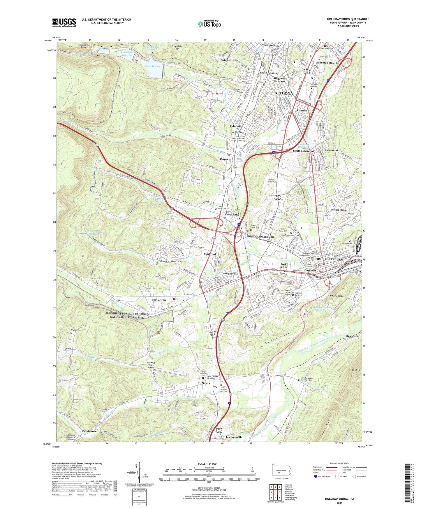
2019 topographic map quadrangle Hollidaysburg in the state of Pennsylvania. Scale: 1:24000. Based on the newly updated USGS 7.5' US Topo map series, this map is in the following counties: Blair. The map contains contour data, water features, and other items you are used to seeing on USGS maps, but also has updated roads and other features. This is the next generation of topographic maps. Printed on high-quality waterproof paper with UV fade-resistant inks.
Quads adjacent to this one:
West: Cresson
Northwest: Ashville
North: Altoona
Northeast: Bellwood
East: Frankstown
Southeast: Martinsburg
South: Roaring Spring
Southwest: Blue Knob
Contains the following named places: Allegheny 1 Elementary School, Allegheny 2 Elementary School, Allegheny Furnace, Allegheny Township Fire Department Station 50, Allegheny Township Fire Department Station 50 Canaan Station, Allegheny Township Police Department, Alto Rest Park, Alto Reste Burial Park, Altoona Fire Department Station 340, Altoona Mobile Emergency Department Authority Station 480 Lakemont Substation, Baker Elementary School, Beryl, Biddle Hollow Dam, Bishop Guilfoyle Catholic High School, Blair County Sheriff's Office, Blair Elementary School, Blair Gap Run, Blair Township Police Department, Blairmont Country Club, Blue Knob Run, Blue Knob Valley Airport, Borough of Duncansville, Borough of Hollidaysburg, Borough of Newry, Burgoon Run, Calvary Cemetery, Canan, Canan Station, Canan Station Census Designated Place, Carson Valley, Carson Valley Cemetery, Carson Valley Census Designated Place, Carson Valley Church, Catfish Ridge, Central School, Charles W Longer Elementary School, Chimney Rocks, Coburn, County Home Cemetery, Cross Keys, Cross Keys Census Designated Place, Curtin Elementary School, Dell Delight Legion Park, Dry Run, Dry Run Cemetery, Dry Run Church, Duncansville, Duncansville Dam, Duncansville Fire Department Station 20, Duncansville Police Department, Duncansville Post Office, Duncansville Reservoir, Dysart Park, Ebensburg Storage Dam, Edison School, Eldorado, Eldorado Cemetery, Eldorado Census Designated Place, Foot of Ten, Foot of Ten Census Designated Place, Fort Fetter, Fort Fetter Census Designated Place, Gaysport, Gillans Run, Glenwhite Run, Greenlawn Cemetery, Halter Creek, HealthSouth Rehabilitation Hospital of Altoona, Highland Park, Hileman Heights, Hillcrest School, Holliday Burial Ground, Hollidaysburg, Hollidaysburg American Legion Ambulance Service, Hollidaysburg Area Junior High School, Hollidaysburg Area Junior High School Grade Six, Hollidaysburg Area Senior High School, Hollidaysburg Borough Police Department, Hollidaysburg Post Office, Hollidaysburg Presbyterian Cemetery, Hollidaysburg Reservoir, Hollidaysburg State Hospital, Horseshoe Curve, Hutchinson Cemetery, Jackson Burial Ground, James E Van Zandt Veterans Administration Medical Center, Kittanning Gap, Kittanning Point, Kittanning Reservoir, Kittanning Trail Volunteer Fire Department Station 14, Kladder Station, Lake Altoona, Lake Altoona Dam, Lakemont, Lakemont Census Designated Place, Lakemont Park, Lakemont Park Dam, Lakemont Reservoir, Lakemont School, Lakemont Volunteer Fire Company 1 Station 15, Llyswen, Logan Police Department, Logan Valley Mall, Lower Kittanning Dam, Mansion Park, Maple Hollow, McDonald Run, McDowell Cemetery, Mill Run, New Saint Marys Cemetery, Newry, Newry Lutheran Cemetery, Newry Post Office, Old Saint Marys Cemetery, Park Hill Golf Club, Park Hills Plaza, Penn Farms, Penn Farms Census Designated Place, Pennsylvania State Police Troop G Holidaysburg Station and Troop Headquarters, Phoenix Steam Fire Engine Company Station 10, Pine Grove UBC Church and Cemetery, Poplar Run, Puzzletown, Puzzletown Census Designated Place, Reservoir, Reservoir Census Designated Place, Saint Bernadines Monastery, Saint Bernardine Monastery Cemetery, Saint Johns School, Saint Marys School, Saint Michaels School, Saint Patricks Cemetery New, Saint Patricks Cemetery Old, Saint Rose of Lima School, Scotch Gap Run, Scotch Run Dam, Scotch Run Reservoir, Short Mountain, South Altoona, South Lakemont, Spencer Run, Stiffler, Sugar Run, Sunbrook, Sunbrook Census Designated Place, Sylvan Hills, Sylvan Hills Census Designated Place, Township of Allegheny, Township of Blair, Township School Number 1, Tuckahoe Park, Union African Methodist Episcopal Cemetery, Upper Kittanning Dam, WFBG-AM (Altoona), Whittier School, Wilson School, Wolf Academy, WPRR-FM (Altoona), WVAM-AM (Altoona), Zion Lutheran Cemetery, ZIP Codes: 16635, 16641, 16665