MyTopo
Oakdale Pennsylvania US Topo Map
Couldn't load pickup availability
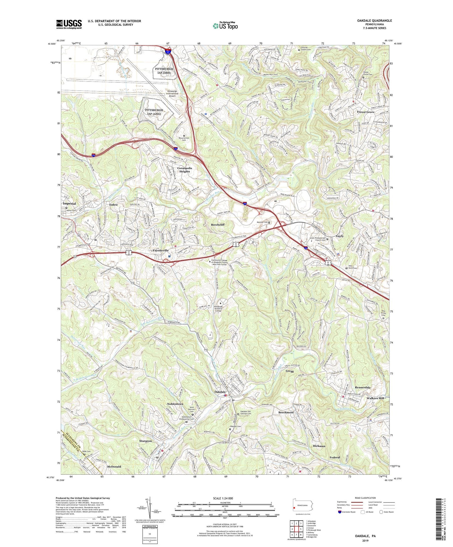
2019 topographic map quadrangle Oakdale in the state of Pennsylvania. Scale: 1:24000. Based on the newly updated USGS 7.5' US Topo map series, this map is in the following counties: Allegheny, Washington. The map contains contour data, water features, and other items you are used to seeing on USGS maps, but also has updated roads and other features. This is the next generation of topographic maps. Printed on high-quality waterproof paper with UV fade-resistant inks.
Quads adjacent to this one:
West: Clinton
Northwest: Aliquippa
North: Ambridge
Northeast: Emsworth
East: Pittsburgh West
Southeast: Bridgeville
South: Canonsburg
Southwest: Midway
Contains the following named places: Beechcliff, Beechmont, Bon Air Golf Course, Borough of Oakdale, Bradley Center, Bradley School, Church of the Living Christ, Cliff Mine, Collier Police Department, Collier Township Hall, Collier Township Police Department, Coraopolis Heights, Coraopolis Heights Golf Course, Crossroads Preschool, Crossroads United Methodist Church, Enlow, Enlow Census Designated Place, Fayetteville, Federal, Federal United Methodist Church, Felician Sisters Cemetery, Fink Run, Forest Grove, Forest Grove Cemetery, Forest Grove Presbyterian Church, Forest Grove Volunteer Fire Department 243, Gayly, Gregg, Half Crown Run, Hickman, Holy Souls Cemetery, Holy Trinity Cemetery, Holy Trinity School, Huntington Learning Center, Imperial, Imperial Census Designated Place, Imperial Post Office, Imperial-Enlow Census Designated Place, Kelly Support Center, Kindred Hospital Pittsburgh, Lintons Run, McClarens Run, McKee Elementary School, Meeks Creek, Meeks Run, Montour Cemetery, Montour Church, Montour Heights Country Club, Montour Joint School, Montour Park, Montour Post Office, Moon Run Volunteer Fire Department Station 245, Noblestown, Noblestown Census Designated Place, Noblestown Presbyterian Cemetery, Noblestown United Presbyterian Church, North Branch Robinson Run, North Fayette Township Police Department, North Fayette Township Volunteer Fire Department Station 209, Oak Ridge Volunteer Fire Department Station 269, Oakdale, Oakdale AHP, Oakdale Borough Police Department, Oakdale Cemetery, Oakdale Hose Company Station 215, Oakdale Old German Cemetery, Oakdale Post Office, Our Lady of Fatima Church, Parkway West Alternative Vocational Technical School, Pennsylvania State Police Troop B Pittsburgh Station, Pinkertons Run, Pittsburg International Airport Post Office, Pittsburgh Airport Air Reserve Station, Plaza at Robinson Town Centre Shopping Center, Providence Presbyterian Church in America, Rennerdale, Rennerdale Census Designated Place, Rennerdale Volunteer Fire Department Station 126, Resurrection Cemetery, Resurrection Lutheran Church, Robb Cemetery, Robinson Emergency Medical Services Station 730, Robinson Towne Centre Shopping Center, Robinson Township Census Designated Place, Robinson Township Christian School, Robinson Township Fire Department, Robinson Township Hall, Robinson Township Police Department, Saint Columbkille School, Saint Patrick Church Social Hall, Saint Patrick's Cemetery, Saint Vincent DePaul Church, Scott Station, Scotts Run, Settlers Cabin County Regional Park, Shepard Elementary School, Sturgeon, Sturgeon Census Designated Place, Sturgeon Post Office, Sturgeon Volunteer Fire Department Station 267, Sturgeon-Noblestown Census Designated Place, The Mall at Robinson Shopping Center, Township of Collier, Township of North Fayette, Township of Robinson, Trout Run, Union Cemetery, Union Presbyterian Church of Robinson Township, Union United Church, Valley Cemetery, Valley Presbyterian Church, Walkers Mill, West Allegheny High School, West Allegheny Middle School, West Hills Alliance Church, Western Allegheny Community Library, Western Area Special School, ZIP Codes: 15071, 15082