MyTopo
Canonsburg Pennsylvania US Topo Map
Couldn't load pickup availability
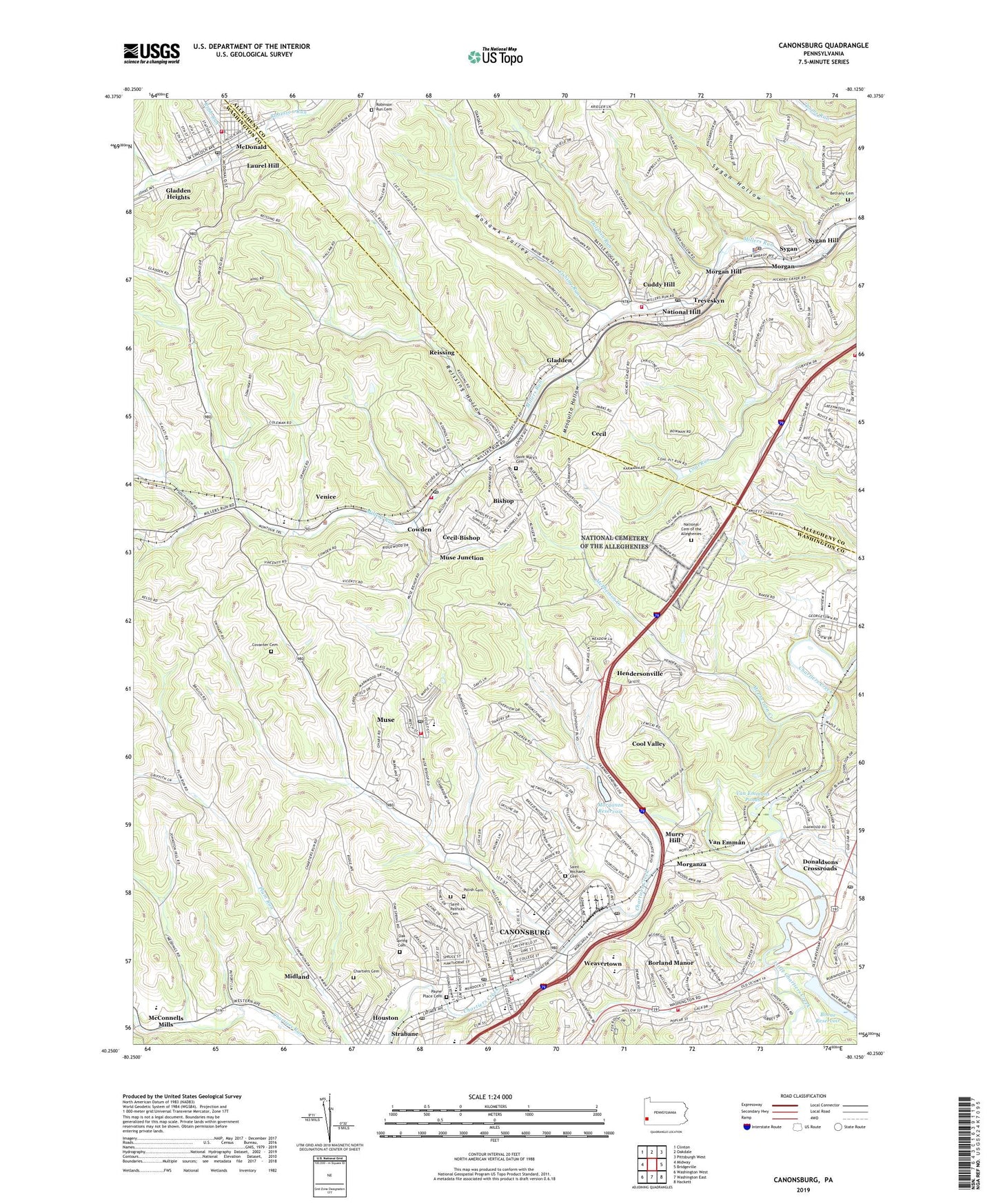
2023 topographic map quadrangle Canonsburg in the state of Pennsylvania. Scale: 1:24000. Based on the newly updated USGS 7.5' US Topo map series, this map is in the following counties: Washington, Allegheny. The map contains contour data, water features, and other items you are used to seeing on USGS maps, but also has updated roads and other features. This is the next generation of topographic maps. Printed on high-quality waterproof paper with UV fade-resistant inks.
Quads adjacent to this one:
West: Midway
Northwest: Clinton
North: Oakdale
Northeast: Pittsburgh West
East: Bridgeville
Southeast: Hackett
South: Washington East
Southwest: Washington West
This map covers the same area as the classic USGS quad with code o40080c2.
Contains the following named places: Alcoa Dam, Alexander School, All Saints Greek Orthodox Church, Bellevue Borough Hall, Bellevue Police Department, Bethany Cemetery, Bishop, Boone Reservoir, Borland Manor, Borland Manor Elementary School, Borough of Canonsburg, Borough of McDonald, Brighter Futures Child Development Center, Brush Run, Cabana Beach Park, Calvary Full Gospel Church, Campbell Airport, Canon McMillan Junior High School, Canon-McMillan High School, Canonsburg, Canonsburg Borough Police Department, Canonsburg Carrier Annex Post Office, Canonsburg City Hall, Canonsburg Lake, Canonsburg Post Office, Canonsburg Town Park, Canonsburg Volunteer Fire Department, Cecil, Cecil Elementary School, Cecil Junior High School, Cecil Post Office, Cecil Township Hall, Cecil Township Police Department, Cecil Township Volunteer Fire Company 2 Station 29, Cecil Township Volunteer Fire Department Station 3, Cecil-Bishop Census Designated Place, Chartiers Cemetery, Cool Valley, Covenanter Cemetery, Cowden, Cuddy Hill, Cuddy Post Office, Dolphin Run, Donaldsons Crossroads, Donaldsons Crossroads Shopping Center, Fairview Volunteer Fire Department Station 268, First Baptist Church of McDonald, First Ward School, Fishing Run, Gladden, Gladden Heights, Gradatim Post Office, Greater Canonsburg Public Library, Hawthorne School, Hendersonville, Hendersonville Census Designated Place, Heritage Public Library, Independent Bible Presbyterian Church, Irons Memorial Church, Lakeview Christian Life Church, Laurel Hill, Little Chartiers Creek, Mc Murray Post Office, McClellan Elementary School, McConnells Mills, McDonald, McDonald Alliance Church, McDonald Borough Hall, McDonald Borough Police Department, McDonald Police Department, McDonald Post Office, McDonald Presbyterian Church, McDonald Volunteer Fire Department Station 12, McMillans Academy, McNary, McPherson Creek, Midland, Millers Run Church, Mohawk Valley, Morgan, Morgan Hill, Morgan Post Office, Morganza, Morganza Dam, Morganza Reservoir, Mosquito Hollow, Murry Hill, Muse, Muse Census Designated Place, Muse Elementary School, Muse Junction, Muse Post Office, National Cemetery of the Alleghenies, National Hill, North Strabane Volunteer Fire Department Station, Oak Spring Cemetery, Payne African Methodist Episcopal Church Cemetery, Pennsylvania State Training School, Reissing, Reissing Hollow, Robb Run, Robinson Run Cemetery, Sacred Heart of Jesus Polish National Catholic Church, Sacred Heart of Jesus Polish National Catholic Church Cemetery, Saint Alphonsus Church, Saint Mary's Cemetery, Saint Michaels Cemetery, Saint Patrick School, Saint Patricks Cemetery, South Central Avenue Elementary School, South Fayette Township Library, South Fayette Township Police Department, South Fayette Volunteer Fire Department - Station 266, Speers Run Dam, Strabane, Strabane Post Office, Sygan, Sygan Hill, Sygan Hollow, Third Ward School, Township of Cecil, Township of Chartiers, Township of South Fayette, Treveskyn, Valleybrook Golf Course, Van Emman, Van Emmans Ponds, Venice, Wade Academy Day Care Center, WARO-AM (Canonsburg), Waterdam Church, Weavertown, ZIP Codes: 15031, 15057, 15064, 15317, 15321, 15350, 15363