MyTopo
Pittsburgh West Pennsylvania US Topo Map
Couldn't load pickup availability
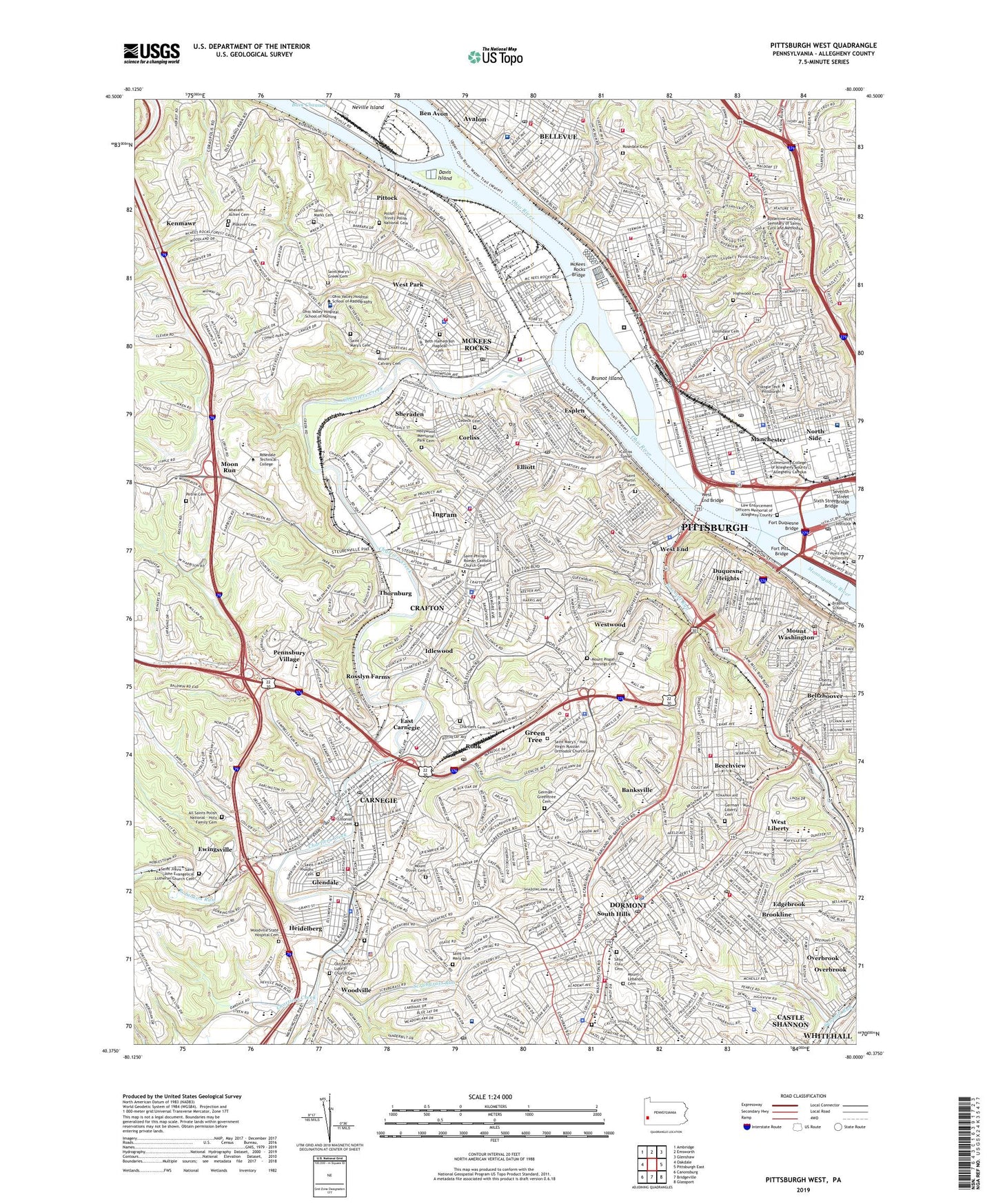
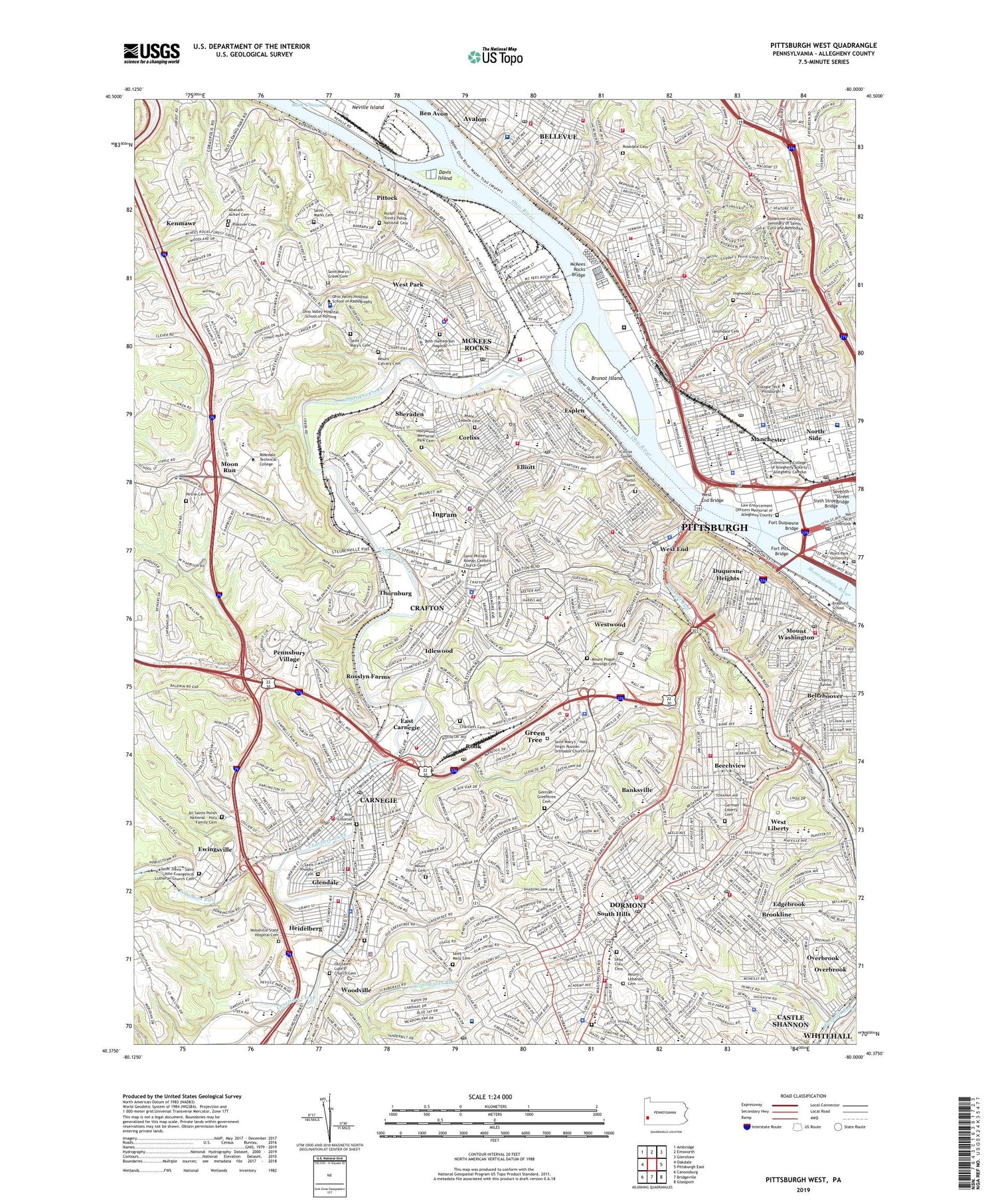
2019 topographic map quadrangle Pittsburgh West in the state of Pennsylvania. Scale: 1:24000. Based on the newly updated USGS 7.5' US Topo map series, this map is in the following counties: Allegheny. The map contains contour data, water features, and other items you are used to seeing on USGS maps, but also has updated roads and other features. This is the next generation of topographic maps. Printed on high-quality waterproof paper with UV fade-resistant inks.
Quads adjacent to this one:
West: Oakdale
Northwest: Ambridge
North: Emsworth
Northeast: Glenshaw
East: Pittsburgh East
Southeast: Glassport
South: Bridgeville
Southwest: Canonsburg
Contains the following named places: Ahavath Achim Cemetery, All Saints Polish National Cemetery, Allegheny, Allegheny Center, Allegheny Center Mall, Allegheny General Hospital, Allegheny General Hospital Suburban Campus, Allegheny High School, Allegheny Observatory, Allegheny River, Annunication School, Assumption School, Banksville, Beechview, Belasco Station, Bellevue, Beltzhoover, Beth Hamedrash Hagodol - Beth Jacob Cemetery, Boggs Station, Bon Air, Booth Memorial Hospital, Borough of Bellevue, Borough of Carnegie, Borough of Crafton, Borough of Dormont, Borough of Green Tree, Borough of Heidelberg, Borough of Ingram, Borough of McKees Rocks, Borough of Pennsbury Village, Borough of Rosslyn Farms, Borough of Thornburg, Boustead Station, Brighton Heights, Brookline, Brunot Island, Byzantine Seminary, California Kirkbride, Campbells Run, Canevin High School, Carnegie, Carnegle Park, Chartier Valley High School, Chartiers, Chartiers Cemetery, Chartiers Creek, Chartiers Heights Country Club, City View, Clark High School, Coast Station, Corliss, Corliss Tunnel, Cowley School, Crafton, Crafton Golf Course, Davis Island, Davis School, Dawn Station, DePaul Institute, Dormont, Dormont Park, Downtown, Duquesne Heights, Duquesne Incline, East Carnegie, East Park, East Street Bridge, Edgebrook, Elliott, Esplen, Ewingsville, Fairywood, Fairywood School, Fallowfield Station, Fineview, First Ward School, Fort Duquesne Bridge, Fort Pitt, Fort Pitt Bridge, Fort Pitt Tunnel, Gateway Clipper Fleet Dock, Georges Run, Glendale, Golden Triangle, Grant School, Grant Street School, Green Tree, Greentree Cemetery, Hampshire Station, Heidelberg, Heinz Field, Highwood Cemetery, Hollywood Memorial Park Cemetery, Holy Trinity Polish National Cemetery, Holy Virgin Russian Orthodox Church Cemetery, Idlewood, Ingram, Jacks Run, Kane Memorial Hospital, KDKA-TV (Pittsburgh), Kelton Station, Kenmawr, Kennedy Township Census Designated Place, Kindred Hospital Pittsburgh North Shore, Law Enforcement Officers Memorial of Allegheny County, Liberty Tunnel, Manchester, Market Square, Marshall Shadeland, McKees Rocks, McKees Rocks Bridge, McKinley Park, Mexican War Streets, Monogahela Incline, Monongahela River, Moon Run, Mount Calvary Cemetery, Mount Lebanon Cemetery, Mount Lebanon Census Designated Place, Mount Lebanon Station, Mount Olivet Cemetery, Mount Pisgah Cemetery, Mount Washington, Mount Washington Overlook, Mount Washington Park, Neeld Station, North Park, North Shore, North Side, Northview Heights, Ohio Valley Hospital, Old Saint Luke's Church Cemetery, Olympia Park, Palm Garden Station, Pennant Station, Pennsbury Village, Perry Hilltop, Perry North, Petrie Cemetery, Piskover Cemetery, Pittock, Pittsburgh and Lake Erie Station, Pittsburgh Aviary Conservatory, PNC Park, Poale Zedeck Cemetery, Point Bridge, Point State Park, Poplar Station, Potomac Station, Riverview Park, Roberto Clemente Memorial Park, Robinson Run, Rook, Rook Rail Yard, Rosedale Cemetery, Ross Colonial Cemetery, Rosslyn Farms, Saint Clair Cemetery, Saint Clair Hospital, Saint John Evangelical Lutheran Church Cemetery, Saint Johns General Hospital, Saint Josephs Cemetery, Saint Marks Cemetery, Saint Martin Cemetery, Saint Mary Cemetery, Saint Mary's Cemetery, Saint Mary's Greek Cemetery, Saint Phillips Roman Catholic Church Cemetery, Saints Peter and Paul Ukrainian Cemetery, Sawmill Run, Scott Township Census Designated Place, Scrubgrass Run, Scully Yard, Seventh Street Bridge, Sheraden, Sheraden Park, Shiras Station, Sixth Street Bridge, South Hills, South Hills Junction Station, Southminster Presbyterian Church Columbarium, Station Square, Station Square Station, Stevenson Station, Stowe Township Census Designated Place, Summer Hill, The Landing at Station Square, Thornburg, Three Rivers Stadium, Township of Baldwin, Township of Kennedy, Township of Mount Lebanon, Township of Scott, Township of Stowe, Traymore Station, Uniondale Cemetery 1, Viking Airport, WBZZ-FM (Pittsburgh), WDUQ-FM (Pittsburgh), WDVE-FM (Pittsburgh), West End, West End Bridge, West End Park, West Liberty, West Liberty Cemetery, West Park, Westfield Station, Westwood, Whiskey Run, Whites Ripple, Wilson Park, Windgap, Woods Run, Woodville, Woodville State Hospital, Woodville State Hospital Cemetery, WPGH-TV (Pittsburgh), WPLW-AM (Carnegie), WPNT-FM (Pittsburgh), WPXI-TV (Pittsburgh), WSHH-FM (Pittsburgh), WWSW-FM (Pittsburgh), ZIP Codes: 15106, 15136, 15142, 15204, 15205, 15211, 15214, 15216, 15220, 15226, 15233, 15243, 15290